Maps of Radyvyliv Raion


Beresteczko und Szczurowice.
from Spezialkarte der osterreichisch-ungarischen Monarchie.
Karte des Westlichen Russlands: Q39 Luck

Brody.
from Spezialkarte der osterreichisch-ungarischen Monarchie.
Teremno und Zurawicze
1 : 75000 Jakubec, J. K. u. k. Militärgeographisches Institut
Dubno
1 : 75000 Fitz, J. K. u. k. Militärgeographisches Institut
Dubno
1 : 75000 Fitz, J. K. u. k. Militärgeographisches Institut
Kremieniec
1 : 75000 Kremenec (Ukrajina) Nikel, L. K. u. k. Militärgeographisches Institut
Łuck
1 : 75000 Luck-oblast (Ukrajina) Brantner, A. K. u. k. Militärgeographisches Institut
Brody
1 : 75000 Ukrajina Stotz, A. K. u. k. Militärgeographisches Institut
Ołyka und Młynow
1 : 75000 Dokaupil, R. K. u. k. Militärgeographisches Institut
Rozyszcze
1 : 75000 Bloschitz, R. K. u. k. Militärgeographisches Institut
Beresteczko und Szczurowice
1 : 75000 Bittmann, V. K. u. k. Militärgeographisches Institut
Neue Generalkarte des Österr.-ungar.-russischen Kriegsschauplatzes

Generalkarte von Zentraleuropa

Generalkarte von Zentraleuropa

Generalkarte von Zentraleuropa

Generalkarte von Zentraleuropa


Zalozce.
from Spezialkarte der osterreichisch-ungarischen Monarchie.
Zloczow.
from Spezialkarte der osterreichisch-ungarischen Monarchie.
Mielnica
1 : 75000 K. u. k. Militärgeographisches Institut
Załoźce
1 : 75000 Ukrajina Ahl, W. K. u. k. Militärgeographisches Institut
Złoczów
1 : 75000 Ukrajina Hanusch, Ed. K. u. k. Militärgeographisches Institut
Kolki
1 : 75000 K. u. k. Militärgeographisches Institut
Strategische Übersichts-Karte des polnisch-litaurischen Armee-Bewegungraumes

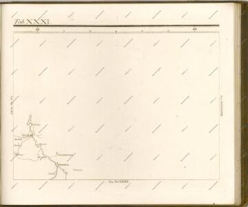
Lubomeriae et Galliciae Regni Tabula Geographica
1 : 1100000 Mollova mapová sbírka Homann, Johann Baptist Homann, Johann Baptista - dědici