Maps of Radyvyliv

Brody
1 : 75000 Ukrajina Stotz, A. K. u. k. Militärgeographisches Institut
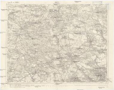
Brody.
from Spezialkarte der osterreichisch-ungarischen Monarchie.


Beresteczko und Szczurowice.
from Spezialkarte der osterreichisch-ungarischen Monarchie.
Generalkarte von Zentraleuropa

Generalkarte von Zentraleuropa

Neue Generalkarte des Österr.-ungar.-russischen Kriegsschauplatzes

Übrige Länder der ehemaligen Österreich-Ung. Monarchie
1 : 900000 Halič (Polsko a Ukrajina) Koch, Wilhelm Opitz, Carl Arnd
Carte de la Roumanie et pays limitrophes. Lemberg
1 : 500000 France. Service géographique de l'armée [Paris] : Service géographique de l'armée
Galizien, Östlicher Theil und Bukowina
1 : 700000 Bukovina (Rumunsko a Ukrajina) Karl Fr. Pfau
Sheet V: Karte Des Oesterreichischen Kaiserstaates.
1 : 576000 Scheda, Josef
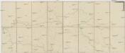
Bez titulu: Šest listů speciálních map Ukrajiny

Übersichtskarte von Mittel - Europa

V, uit: General-Karte des oesterreichischen Kaiserstaates mit einem grossen Theile der angrenzenden Länder / durch Josef Scheda ... bearb. und hrsg
1 : 576000 Annotatie geografische gegevens: Maatstokken: oesterreichische Meilen, geografische oder deutsche Meilen, preussische Meilen, türkische Berri, französische Lieues, russische Werste; Maatstok per blad: wiener Klafter, öster. Meilen; Blad XIX: statistische en taalkundige informatie; Blad XIX: legenda [Wien : K.K. Militärisch-Geografisches Institut]
Pohlen, Rußland, Gallicien, Wolhinien, Podolien. Ungarn. Ungvárer Comitat
Ungarn Verkehrsweg
Strassen- und Eisenbahnkarte des oesterreichischen Kaiserthumes
1 : 864000 Blatt 4 Schaller, G. K.K. Militärisch-Geografisches Institut, Karten-Evidenthaltungs-Abteilung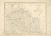
Strassen und Eisenbahnkarte des oesterreichischen Kaiserthumes

Strategische Übersichts-Karte des polnisch-litaurischen Armee-Bewegungraumes
Halič
Halič (Polsko a Ukrajina)
Lubomeriae et Galliciae Regni Tabula Geographica
1 : 1100000 Mollova mapová sbírka Homann, Johann Baptist Homann, Johann Baptista - dědici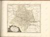

Blatt IV, uit: Geologische Übersichts-Karte der Österreichisch-Ungarischen Monarchie / nach den Aufnahmen der K.K. Geologischen Reichsanstalt bearb. von Franz Ritter von Hauer ; gezeichn. von Eduard Jahn
1 : 576000 Annotatie geografische gegevens: Gebaseerd op veldwerk in de jaren 1850 tot 1865 Hauer, Franz Ritter von; Jahn, Eduard; Kaiserlich-Königliche Geologische Reichsanstalt, Wenen Wien : Beck
Russie noire / tirée pour la plus grande partie de la grande carte de l'Ukraine, du Sr. le Vasseur
1 : 870000 1 Karte : Kupferdruck ; 44 x 50 cm Sanson, Nicolas chez P. Marinette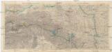
Galizien 1:750 000
1 : 750000 Halič (Polsko a Ukrajina) Artaria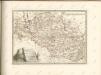

Carte nouvelle des royaumes de Galizie et Lodomerie avec le district de Bukowine
1 : 956000 Bukovina (Rumunsko a Ukrajina) Probst, Johann Michael chez Iean Michel Probst