Maps of Zboriv Raion

Zloczow.
from Spezialkarte der osterreichisch-ungarischen Monarchie.
Złoczów
1 : 75000 Ukrajina Hanusch, Ed. K. u. k. Militärgeographisches Institut
Pomorzany.
from Spezialkarte der osterreichisch-ungarischen Monarchie.
Brody.
from Spezialkarte der osterreichisch-ungarischen Monarchie.
Zalozce.
from Spezialkarte der osterreichisch-ungarischen Monarchie.
Busk und Krasne.
from Spezialkarte der osterreichisch-ungarischen Monarchie.
Avstro - Vengrija. Pomožany
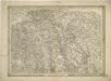
General-Karte des Königreiches Galizien und des Herzogthumes Bukovina

Generalkarte von Zentraleuropa

Generalkarte von Zentraleuropa


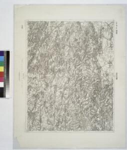
Pomorzany
1 : 75000 Ukrajina K. u. k. Militärgeographisches Institut

Busk und Krasne
1 : 75000 Ukrajina Fitz, J. K. u. k. Militärgeographisches Institut
Kamionka Strumilowa.
from Spezialkarte der osterreichisch-ungarischen Monarchie.
Przemyslany.
from Spezialkarte der osterreichisch-ungarischen Monarchie.
Załoźce
1 : 75000 Ukrajina Ahl, W. K. u. k. Militärgeographisches Institut
Tarnopol.
from Spezialkarte der osterreichisch-ungarischen Monarchie.
Brody
1 : 75000 Ukrajina Stotz, A. K. u. k. Militärgeographisches Institut
Przemyślany
1 : 75000 Ukrajina Hauk, J. K. u. k. Militärgeographisches Institut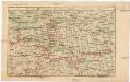
Strecke
Ivano-Frankivsk (Ukrajina) K. k. Österreichische Staatsbahnen
Ost Galizien
Halič (Polsko a Ukrajina) Liesganig, Joseph m Verlage des Kunst- und Industrie- Comptoirs
Tarnopol, Brody, Stryj, Czernowitz
1 : 750000 Brody (Ukrajina) Erben, F. K. u. k. Militärgeographisches Institut
Tarnopol, Brody, Stryj, Czernowitz
1 : 750000 Brody (Ukrajina) Erben, F. K. u. k. Militärgeographisches Institut
Tarnopol, Brody, Stryj, Czernowitz
1 : 750000 K. u. k. militär-geographisches Institut
Tarnopol, Brody, Stryj, Czernowitz
1 : 750000 Brody (Ukrajina) K. k. militär-geographisches Institut
Übrige Länder der ehemaligen Österreich-Ung. Monarchie
1 : 900000 Halič (Polsko a Ukrajina) Koch, Wilhelm Opitz, Carl Arnd