Maps of Europe

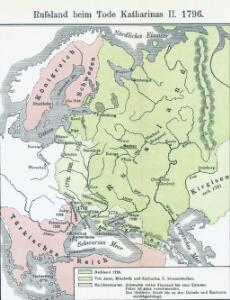
Russland beim Tode Katharinas II. 1796
Russland
Russland beim Tode Peters d. Gr. 1725
Russland
Ost Europa
1 : 12500000 Russland / Europäischer Teil
Russland 1682-1762
1 : 18000000 Russland Expansion
Des Russischen Reichs Europäischer Theil
Stieler's Hand-Atlas Stieler, Adolf bei Justus Perthes
Sarmatische Tiefebene
Osteuropa, Ostmitteleuropa
Skandinavien und Rußland
1 : 18000000 Skandinavien, Osteuropa
Rußland
1 : 18000000 Russland / Europäischer Teil
Carte de la Pologne à son apogee, sous Sigismond-Auguste, en face du Principat de Russie sous le czar Ivan IV, vers l’an 1570 de notre ère
Polen Russland Polen-Litauen Zygmunt August
Kompas omniumkaart bevattende: Noorwegen, Zweden, Finland, Europeesch Rusland, Europ. en Aziatisch Turkije, Irak, Middell. Zeegebied, en Suez
1 : 5500000 Den Haag : Kompas
Russland
1 : 36000000 Russland / Europäischer Teil
Russland
1 : 15000000 Evropa východní Kocen, Blaž Eduard Hölzel
Skandinavien und Rußland
1 : 18000000 Skandinavien, Osteuropa
Europaeisches Russland mit Polen
Geographischer Atlas über alle Theile der Erde Ziegler, Jakob Melchior Verlag von Joh. Wurster um Comp.
Europaeisches Russland
Plastischer Schul-Atlas über alle Theile der Erde : in 24 Karten Woldermann, G Verlag von P. Eckerlein
Eastern Europe.
1 : 14495100 Fisher, Richard Swainson
Das europäische Russland
Schul-Atlas in 36 Karten Völter, Daniel Verlag der J.M. Dannheimer'schen Buchhandlung
Rußland
1 : 18000000 Russland / Europäischer Teil
Russland
Neuer Handatlas über alle Theile der Erde Kiepert, Heinrich Verlag von Dietrich Reimer
Russland beim Tode Iwans II. 1584
Russland
Ruszland
1 : 12000000 Russland / Europäischer Teil
[Europ. Russland]
[Allgemeiner Atlas über alle Theile der Erde in 29 Blättern] Ziegler, Jakob Melchior Top. Anstalt v. J. Wurster u. Comp.
Europäisches Russland
1 : 20500000 Russland / Europäischer Teil
Tabula Russiae [...] [Karte] Moscua ad Architypum Foedori Borißowitsi [Planvedute, Karte], in: Le théâtre du monde, ou, Nouvel atlas contenant les chartes et descriptions de tous les païs de la terre, Bd. 1, S. 67.
1 Karte aus Atlas Blaeu, Willem Janszoon und Blaeu, Joan Blaeu, Willem Janszoon
Tabula Russiae ex autographo, quod delineandum curavit Foedor filius Tzaris Boris desumta [...] [Karte], in: Theatrum orbis terrarum, sive, Atlas novus, Bd. 1, S. 67.
1 Karte aus Atlas Blaeu, Joan Blaeu, Willem Janszoon
Novissima Russiae Tabula [Karte], in: Novus atlas absolutissimus, Bd. 1, S. 70.
1 Karte aus Atlas Janssonius Offizin
Novissima Russiae Tabula [Karte], in: Gerardi Mercatoris et I. Hondii Newer Atlas, oder, Grosses Weltbuch, Bd. 1, S. 124.
1 Karte aus Atlas Mercator, Gerhard und Hondius, Jodocus Jansson, Jan
Europäisches Russland
1 : 16000000 Russland / Europäischer Teil
Europaeisches Russland mit Polen
Geographischer Atlas über alle Theile der Erde Ziegler, Jakob Melchior Verlag von Dietrich Reimer