Maps of Europe

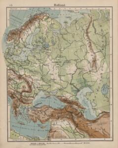
Rußland
1 : 18000000 Russland / Europäischer Teil
Rußland
1 : 18000000 Russland / Europäischer Teil
Europaeisches Russland
E. von Sydow's Schul-Atlas in sechs und dreissig Karten Sydow, Emil von bei Justus Perthes
Kompas omniumkaart bevattende: Noorwegen, Zweden, Finland, Europeesch Rusland, Europ. en Aziatisch Turkije, Irak, Middell. Zeegebied, en Suez
1 : 5500000 Den Haag : Kompas
Skandinavien und Rußland
1 : 18000000 Skandinavien, Osteuropa
Russland
Volksschul-Atlas über alle Teile der Erde Lange, Henry Druck und Verlag von Georg Westermann
Europaeisches Russland mit Kasan, Astrachan und Georgien
Schul-Atlas über alle Theile der Erde nach dem neuesten Zustande, und über das Weltgebäude Stieler, Adolf Justus Perthes
Europaeisches Russland
Plastischer Schul-Atlas über alle Theile der Erde : in 24 Karten Woldermann, G Verlag von P. Eckerlein
Tabula Russiae [...] [Karte] Moscua ad Architypum Foedori Borißowitsi [Planvedute, Karte], in: Le théâtre du monde, ou, Nouvel atlas contenant les chartes et descriptions de tous les païs de la terre, Bd. 1, S. 67.
1 Karte aus Atlas Blaeu, Willem Janszoon und Blaeu, Joan Blaeu, Willem Janszoon
Sarmatische Tiefebene
Osteuropa, Ostmitteleuropa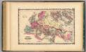
Roman Empire.
1 : 14572800 Johnson, A.J.
Europaeisches Russland
Grosser Hand-Atlas über alle Theile der Erde in 170 Karten Meyer, J. Verlag des Bibliographischen Instituts
Skandinavien und Rußland
1 : 18000000 Skandinavien, Osteuropa
Russland
Neuer Handatlas über alle Theile der Erde Kiepert, Heinrich Verlag von Dietrich Reimer
Europäisches Russland
Russland / Europäischer Teil
Eastern Europe.
1 : 14495100 Fisher, Richard Swainson
Das europäische Russland
Schul-Atlas in 36 Karten Völter, Daniel Verlag der J.M. Dannheimer'schen Buchhandlung
Carta politica della Russia / Francesco Vallardi
1 : 3300000 Francesco Vallardi
Carte générale orographique et hydrographique de l'Europe, qui montre les principales ramifications des montagnes, fleuves et chemins avec les principales villes
1 : 4600000 dressée d'aprés les meilleures cartes des auteurs les plus acredités par le Général Baron Sorriot de L'Host gravée par Joseph List. Vienne, [s.n.]
[Neuer Atlas der ganzen Erde nach den neuesten Bestimmungen ... : II.] Europa
Entworfen und gezeichnet von F.W. Streit H. Leutemann sc. Leipzig : J.C. Hinrichs'sche Buchhandlung
Kaart van Europa voor schoolgebruik bewerkt / door H. Blink
1 : 3000000 Annotatie: Met: Lengte en vermogen van eenige stroomen onderling vergeleken; Annotatie geografische gegevens: Schaalstok van 300 km; Legenda; 3 bijkaarten 1: Typisch voorbeeld van ligging en profil der fjorden in Noorwegen, 15,5 x 19,5 cm. 2: Simplonpas en St. Gothardspoorweg, schaal 3:500.000, 15,5 x 18,5 cm, resp. 24,5 x 9,5 cm. 3: Kaart van de Alpen, schaal 1:1.500.000, 34 x 49 cm Ten Brink, Meppel Meppel : H. ten Brink / (Groningen : J.H. van de Weijer)
Europa
Handatlas über alle Theile der Erde und über das Weltgebäude Stieler, Adolf Justus Perthes
Novissima Russiae Tabula [Karte], in: Novus atlas absolutissimus, Bd. 1, S. 70.
1 Karte aus Atlas Janssonius Offizin
Tabula Russiae [...] [Karte] Moscua [Planvedute, [Nebenkarte], in: Novus Atlas, das ist, Weltbeschreibung, Bd. 1, S. 55.
1 Karte aus Atlas Blaeu, Joan Blaeu, Willem Janszoon
Russland 1682-1762
1 : 18000000 Russland Expansion
Europa
Schul-Atlas in 36 Karten Völter, Daniel Verlag der J.M. Dannheimer'schen Buchhandlung
Europa
Hypsometrischer Atlas Ziegler, Jakob Melchior Topogr. Anstalt v. J. Wurster u. Comp.
Europa
Neuer Handatlas über alle Theile der Erde Kiepert, Heinrich Verlag von Dietrich Reimer
Karte der Bevölkerung Russlands im 19. Jahrhundert
Russland Bevölkerungsdichte