Maps of Greece

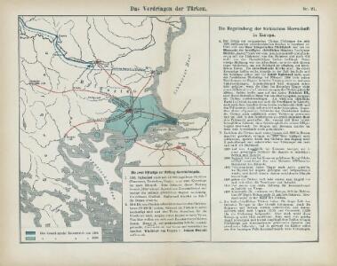
Nr. 21. Das Vordringen der Türken
Osmanisches Reich, Expansion
Die E. Türkei Griechenland und die Ionischen Inseln
Jónské ostrovy (Řecko)
Graecia nova et mare Aegeum s. Archipelagus, in qua mappa Macedonia, Albania, Epirus, Thessalia et Morea, cum circumjacentibus insulis Corcyra, Cephalonia, Zacynthos, Stalimene, Metelino, Chios, distinctae exhibentur
1 : 1660000 Achaia (Řecko) Lotter, Tobias Conrad sumtibus Tobiae Conradi Lotteri
Graecia nova et mare Aegeum s. Archipelagus, in qua mappa Macedonia, Albania, Epirus, Thessalia et Morea cum circumjacentibus insulis Corcyra, Cephalonia, Zacynthos, Stalimene, Metelino, Chios, distinctae exhibentur
1 : 1660000 Achaia (Řecko) Lotter, Tobias Conrad sumtibus Tobiae Conradi Lotteri
Der Europäische Theil des Türkischen Reichs
1 : 2020000 Balkánský poloostrov Reichard, C. G. Campe, Friedrich bei Friedrich Campe
Turkey in Europe.
1 : 5860000 Tanner, Henry S.
Balkanhalbinsel
1 : 5000000 Balkánský poloostrov F. A. Brouckaus' Geogr.-artist. Anstalt
Graecia Antiqua.
1 : 2250000 Playfair, Principal
Des Osmanischen Reichs europäischer Theil, Griechenland und die Jonischen Inseln
osmanská říše Stülpnagel, Friedrich von Jättnig, Karl Justus Perthes
Makedonische Frage: Gebietsansprüche ca. Anfang 1912
Makedonien Balkankrieg <1912-1913>, Territorialer Anspruch Zwick, J. ; Clewing, K.
[Ethnographische Karte des Osmanischen Reichs europäischen Theils und von Griechenland]
Zweiter Band, enthaltend in vier Abtheilungen die Vertheilung der Organismen: 5. Pflanzen-Geographie, 6. Thier-Geographie, 7. Anthropographie, 8. Ethnographie Humboldt, Alexander von Verlag von Justus Perthes
The First Bulgarian Empire
Bulgarien Simeon I., Bulgarien, Zar, Samuil, Bulgarien, Zar
Servia under Dušan c. 1350
Serbien Stefan Dušan, Srbija, Car
Der Balkan nach den Kriegen 1912/13
Südosteuropa, Osmanisches Reich, Balkankriege Häusler, Ines
Soubor němých map pro gymnasia a odborné školy

Die Balkan-Halbinsel
1 : 1500000 Athény (Řecko : oblast) Vogel, Carl Domann, B. Justus Perthes
Die Balkan-Halbinsel
1 : 1500000 Athény (Řecko : oblast) Vogel, Carl Domann, B. Justus Perthes
Die von den Balkanstaaten bis Ende April 1913 besetzten Gebiete
Südosteuropa, Osmanisches Reich, Balkankriege Häusler, Ines
Politisch - militärische Karte der Balkanhalbinsel

Die Staaten der Balkan - Halbinsel

Carte generale de la Turquie d'Europe a la droite du Danube ou des beglerbegliks de Roum Ili, Bosna et Moree
1 : 1300000 Dardanely (Turecko : průliv) Vaudoncourt, Guillaume de Reinhard, Carl Depôt geographique
Gegenwärtig Stand der neuen politischen Grenzen auf der Balkan-Halbinsel
1 : 1600000 Balkánský poloostrov Rothaug, Johann Georg G. Freytag & Berndt
Balkanhalbinsel
1 : 6000000 Balkanhalbinsel Weltkrieg <1914-1918>
Die Balkanländer
1 : 1700000 Dardanely (Turecko : průliv) Carl Flemming
Karte der Balkan-Halbinsel und der angrenzenden Gebiete / nach den neuesten Quellen bearb. von Gustav Freytag
1 : 1600000 Annotatie: Met administratieve indeling van het Koninkrijk Griekenland; Annotatie geografische gegevens: Inzetkrt.: Insel Kreta (Candia) Gustav Freytag [S.l. : A. Hartleben's Verlag]
Mapa rakousko-srbského bojiště
1 : 2000000 Balkánský poloostrov V. Neubert
Mapa rakousko-srbského bojiště
1 : 2000000 Balkánský poloostrov Machát, František V. Neubert
Poloostrov Balkánský
1 : 2750000 Balkánský poloostrov Machát, František J. Otto
Türkei und Griechenland.
1 : 5000000 Osmanisches Reich / Europäischer Teil, Griechenland