Maps of Balkan Pen.

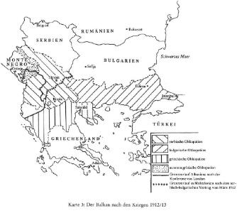
Der Balkan nach den Kriegen 1912/13
Südosteuropa, Osmanisches Reich, Balkankriege Häusler, Ines
Die E. Türkei Griechenland und die Ionischen Inseln
Jónské ostrovy (Řecko)
Servia under Dušan c. 1350
Serbien Stefan Dušan, Srbija, Car
[Nona Europe tabula] [Karte], in: Clavdii Ptholomei Viri Alexandrini Cosmographie, S. 155.
1 Karte aus Atlas Nicolaus Germanus [und Ptolemaeus, Claudius]
Die von den Balkanstaaten bis Ende April 1913 besetzten Gebiete
Südosteuropa, Osmanisches Reich, Balkankriege Häusler, Ines
Carte von der europaischen Türkey
1 : 1950000 Turecko západní Xylander, J. von Walch, Johann Johannes Walch
Turkey in Europe.
1 : 5860000 Tanner, Henry S.
The First Bulgarian Empire
Bulgarien Simeon I., Bulgarien, Zar, Samuil, Bulgarien, Zar
Der Europäische Theil des Türkischen Reichs
1 : 2020000 Balkánský poloostrov Reichard, C. G. Campe, Friedrich bei Friedrich Campe
Nona Europe Tabula [Karte], in: [Clavdii Ptholomei Cosmographi ...], S. 281.
1 Karte aus Atlas Nicolaus Germanus [und Ptolemaeus, Claudius]
Völkerkarte
Südosteuropa Ethnische Gruppe

Graecia nova et mare Aegeum s. Archipelagus, in qua mappa Macedonia, Albania, Epirus, Thessalia et Morea, cum circumjacentibus insulis Corcyra, Cephalonia, Zacynthos, Stalimene, Metelino, Chios, distinctae exhibentur
1 : 1660000 Achaia (Řecko) Lotter, Tobias Conrad sumtibus Tobiae Conradi Lotteri
Graecia nova et mare Aegeum s. Archipelagus, in qua mappa Macedonia, Albania, Epirus, Thessalia et Morea cum circumjacentibus insulis Corcyra, Cephalonia, Zacynthos, Stalimene, Metelino, Chios, distinctae exhibentur
1 : 1660000 Achaia (Řecko) Lotter, Tobias Conrad sumtibus Tobiae Conradi Lotteri
Règions occupèes par les belligèrants fin avril 1913
Südosteuropa Balkankrieg <1912-1913> Besetzte Gebiete
Europäische Türkei seit 1878
1 : 15000000 Balkanhalbinsel, Osmanisches Reich
Des Osmanischen Reichs europäischer Theil, Griechenland und die Jonischen Inseln
Hand-Atlas über alle Theile der Erde nach dem neuesten Zustande und über das Weltgebäude Stieler, Adolf bei Justus Perthes
Die Europaeische Türkei, Griechenland und die Ionischen Inseln
1 : 6000000 Balkanhalbinsel
Europäische Türkei von 1812-1878
1 : 15000000 Osmanisches Reich / Europäischer Teil
Carte de la Turquie d'Europe
Balkánský poloostrov Boué, A. Avril, Ch. chez Arthus-Bertrand
[Ethnographische Karte des Osmanischen Reichs europäischen Theils und von Griechenland]
Zweiter Band, enthaltend in vier Abtheilungen die Vertheilung der Organismen: 5. Pflanzen-Geographie, 6. Thier-Geographie, 7. Anthropographie, 8. Ethnographie Humboldt, Alexander von Verlag von Justus Perthes
Makedonische Frage: Gebietsansprüche ca. Anfang 1912
Makedonien Balkankrieg <1912-1913>, Territorialer Anspruch Zwick, J. ; Clewing, K.
Turkey in Europe.
1 : 3000000 Colton, G.W.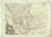
Turquie d'Europe
1 : 2500000 Turecko západní Janvier, Jean Denis Redine, M. Francois Santini
Graecia Antiqua.
1 : 2250000 Playfair, Principal
Des Osmanischen Reichs europäischer Theil, Griechenland und die Jonischen Inseln
osmanská říše Stülpnagel, Friedrich von Jättnig, Karl Justus Perthes
Balkanhalbinsel
1 : 5000000 Balkánský poloostrov F. A. Brouckaus' Geogr.-artist. Anstalt
Des Osmanischen Reichs europäischer Theil, Griechenland und die Jonischen Inseln
Hand-Atlas über alle Theile der Erde nach dem neuesten Zustande und über das Weltgebäude Stieler, Adolf bei Justus Perthes
Bodenschätze und Industrie
Balkanhalbinsel Wirtschaft, Mineralischer Rohstoff
Europaeische Türkey
1 : 5550000 Turecko