Maps of Balkan Pen.

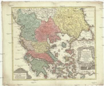
Graecia nova et mare Aegeum s. Archipelagus, in qua mappa Macedonia, Albania, Epirus, Thessalia et Morea, cum circumjacentibus insulis Corcyra, Cephalonia, Zacynthos, Stalimene, Metelino, Chios, distinctae exhibentur
1 : 1660000 Achaia (Řecko) Lotter, Tobias Conrad sumtibus Tobiae Conradi Lotteri
Graecia nova et mare Aegeum s. Archipelagus, in qua mappa Macedonia, Albania, Epirus, Thessalia et Morea cum circumjacentibus insulis Corcyra, Cephalonia, Zacynthos, Stalimene, Metelino, Chios, distinctae exhibentur
1 : 1660000 Achaia (Řecko) Lotter, Tobias Conrad sumtibus Tobiae Conradi Lotteri
Balkanhalbinsel
1 : 5000000 Balkánský poloostrov F. A. Brouckaus' Geogr.-artist. Anstalt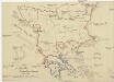
Die E. Türkei Griechenland und die Ionischen Inseln
Jónské ostrovy (Řecko)
Die Balkanländer
1 : 1700000 Dardanely (Turecko : průliv) Carl Flemming
Karte der Balkan-Halbinsel und der angrenzenden Gebiete / nach den neuesten Quellen bearb. von Gustav Freytag
1 : 1600000 Annotatie: Met administratieve indeling van het Koninkrijk Griekenland; Annotatie geografische gegevens: Inzetkrt.: Insel Kreta (Candia) Gustav Freytag [S.l. : A. Hartleben's Verlag]
Der Europäische Theil des Türkischen Reichs
1 : 2020000 Balkánský poloostrov Reichard, C. G. Campe, Friedrich bei Friedrich Campe
Turkey in Europe.
1 : 5860000 Tanner, Henry S.

Übersicht der Bodenkultur
Osmanisches Reich / Europäischer Teil, Griechenland, Bodennutzung
Carte generale de la Turquie d'Europe a la droite du Danube ou des beglerbegliks de Roum Ili, Bosna et Moree
1 : 1300000 Dardanely (Turecko : průliv) Vaudoncourt, Guillaume de Reinhard, Carl Depôt geographique
Makedonische Frage: Gebietsansprüche ca. Anfang 1912
Makedonien Balkankrieg <1912-1913>, Territorialer Anspruch Zwick, J. ; Clewing, K.
Des Osmanischen Reichs europäischer Theil, Griechenland und die Jonischen Inseln
osmanská říše Stülpnagel, Friedrich von Jättnig, Karl Justus Perthes
[Ethnographische Karte des Osmanischen Reichs europäischen Theils und von Griechenland]
Zweiter Band, enthaltend in vier Abtheilungen die Vertheilung der Organismen: 5. Pflanzen-Geographie, 6. Thier-Geographie, 7. Anthropographie, 8. Ethnographie Humboldt, Alexander von Verlag von Justus Perthes
Graecia Antiqua.
1 : 2250000 Playfair, Principal
Die Balkan-Halbinsel
1 : 1500000 Athény (Řecko : oblast) Vogel, Carl Domann, B. Justus Perthes
Die Balkan-Halbinsel
1 : 1500000 Athény (Řecko : oblast) Vogel, Carl Domann, B. Justus Perthes
The First Bulgarian Empire
Bulgarien Simeon I., Bulgarien, Zar, Samuil, Bulgarien, Zar
Turkey in Europe.
1 : 5950000 Lucas, Fielding Jr.
Politisch - militärische Karte der Balkanhalbinsel

Servia under Dušan c. 1350
Serbien Stefan Dušan, Srbija, Car
Der griechisch-türkische Handel im 18. und beginnenden 19. Jh.
Griechenland, Osmanisches Reich, Handel
Turkey in Europe.
1 : 2500000 Arrowsmith, John
Des Osmanischen Reichs europäischer Theil, Griechenland und die Jonischen Inseln
Hand-Atlas über alle Theile der Erde nach dem neuesten Zustande und über das Weltgebäude Stieler, Adolf bei Justus Perthes
Europäische Türkei von 1812-1878
1 : 15000000 Osmanisches Reich / Europäischer Teil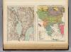
Ethnog. Balkan Peninsula, Constantinople, Sea of Marmara.
1 : 6000000 Andree, Richard; Times (London, England)
Türkei und Griechenland.
1 : 5000000 Osmanisches Reich / Europäischer Teil, Griechenland
Des Osmanischen Reichs europäischer Theil, Griechenland und die Jonischen Inseln
Hand-Atlas über alle Theile der Erde nach dem neuesten Zustande und über das Weltgebäude Stieler, Adolf bei Justus Perthes