Maps of Zapolyarny District

[128][131] Russiae et Novae Zemlae Maritimae, uit: Atlas sive Descriptio terrarum orbis
Annotatie: Gedigitaliseerde versie. Amsterdam. Heiloo : Picturae (vervaardiger), 2015. tiff-bestand. Gedigitaliseerd: 07-01-2015; Origineel: Universiteitsbibliotheek Vrije Universiteit (XL.05127.-) ; Netherlands; Titelpagina ontbreekt Wit, Frederik de Amsterdam : Frederick de Wit
Nördliches Eismeer Häfen in der Barentsee
Barentsovo moře Reichs-Marine-Amt
Feuille 5 (E I), uit: Carte géologique internationale de l'Europe : la carte, votée au congrès géologique international de Bologne en 1881, est exécutée conformément aux décisions d'une commission internationale, avec le concours des gouvernements, sous le dir. de M.M. Beyrich et Hauchecorne
Annotatie: Blad 48 gamme des couleurs; blad 49: bladwijzer en titelblad Heinrich Ernst Beyrich 1815-1896; Wi. Hauchecorne Berlin : Reimer / (Berlin: Institut lithographique)
Russiæ et Novæ Zemlæ maritimæ
1 Karte : Kupferdruck ; 48 x 56 cm Renard Louis Renard
[IV], uit: Geognostische Karte des Oesterreichischen Kaiserstaates mit einem grossen Theile Deutschland's u. Italien / hauptsachlich nach ... Haidinger's geognostischer Karte dieses Staates bearb. von Josef Scheda
1 : 3000000 titelvariant: General-Karte von Europa in 25 Blättern; Annotatie: Bijlage bij: General-Karte von Europa in 25 Blättern. - 1:2.592.000. - 1845-1847 Scheda, Joseph Wien : K.K. Militär. Geografisch. Institut
Partie, Russie d'Europe. Europe 2.
1 : 1641836 Vandermaelen, Philippe, 1795-1869
No.17. Karta Evropeyskaia Rossiia. Sheet 3
1 : 2000000 Shokalskago,Iu. M.
Geognostisch-geographische Übersicht des Petschora Landes
Pečora, řeka (Rusko) Keyserling, Alexander Krusenstern, Paul von
Geognostisch-geographische Übersicht des Petschora Landes
Pečora, řeka (Rusko) Keyserling, Alexander Krusenstern, Paul von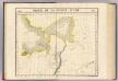
Partie, Russie d'Asie. Asie 5.
1 : 1641836 Vandermaelen, Philippe, 1795-1869
No.16. Karta Evropeyskaia Rossiia. Sheet 2
1 : 2000000 Shokalskago,Iu. M.
Museumskart 176: Kystkart over Finnmark
1 : 100000 Theunis Jacobsz | Pieter Goos
Ice Charts, White Sea (Beloye More). October - June.
U.S. Navy
Merkatorskaja karta rěk
Ilyč, řeka (Rusko) Krusenstern, Paul Theodor von
Finmarkens amt nr 7: Kart over Wardà ̧en med Omegn
1 : 20000
Carte de la Mer Blanche
1 : 2900000 1 Karte : Kupferdruck ; 21 x 16 cm Bellin, Jacques Nicolas [Bellin]
Museumskart 217-19: Kart over Den Norske Kyst fra Tanahorn til Grændsen mod Russisk Lapland
1 : 50000 Hagerup | Klouman | Due | Næser | Vibe Opmaalings Directionen
Museumskart 146: Kart over Den Norske Kyst fra Tanahorn til Grændsen mod Russisk Lapland
1 : 200000 Vibe | Due | Klouman | Næser | Hagerup
Trigonometrisk grunnlag, Squelet-Cart 59
Haffner
Statistikk 43-29-2: Bosettingskart over Kirkenes. Blad 29
1 : 250000 Statistisk Sentralbyrå
Statistikk 43-29- Bosettingskart over Kirkenes. Blad 29
1 : 250000 Statistisk Sentralbyrå
Statistikk 43-32-2: Bosettingskart Vadsø. Blad 32
1 : 250000 Statistisk Sentralbyrå
Røis 349-363-2
Mejlander | Calamus
Geologiske kart 121-T: Kart med magnetisk totalfelt. Vadsø
1 : 250000 Norges geologiske undersøkelse
Statistikk 43-32- Bosettingskart Vadsø. Blad 32
1 : 250000 Statistisk Sentralbyrå
FRETVM NASSOVIVM | Vulgo | DE STRAET NASSOV.
[engraver: Corneel Muller] [Amsterdam : Joan Blaeu]
Ø3 Vardø
1 : 100000 Einar Sigurd Ween | Torgrim Lundtvedt
Æ2 Makkaur
1 : 100000 Finn Abrahamson | H. C. Wanggård
Z3 Tana
1 : 100000 Oluf Lier | Ole Engh
![[128][131] Russiae et Novae Zemlae Maritimae, uit: Atlas sive Descriptio terrarum orbis](https://images-2.georeferencer.com/images/iiif/392314404974/full/,300/0/native.jpg)

