Maps of Komi

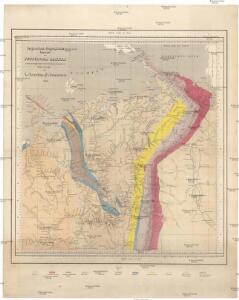
Geognostisch-geographische Übersicht des Petschora Landes
Pečora, řeka (Rusko) Keyserling, Alexander Krusenstern, Paul von
Geognostisch-geographische Übersicht des Petschora Landes
Pečora, řeka (Rusko) Keyserling, Alexander Krusenstern, Paul von
Ost-Europa, Bl. 2: Nordost-Russland.
1 : 3700000 Petermann, A.
Feuille 6 (F I), uit: Carte géologique internationale de l'Europe : la carte, votée au congrès géologique international de Bologne en 1881, est exécutée conformément aux décisions d'une commission internationale, avec le concours des gouvernements, sous le dir. de M.M. Beyrich et Hauchecorne
Annotatie: Blad 48 gamme des couleurs; blad 49: bladwijzer en titelblad Heinrich Ernst Beyrich 1815-1896; Wi. Hauchecorne Berlin : Reimer / (Berlin: Institut lithographique)
Governo di Arcangelo, e sue provincie nella Russia europea / G. Zuliani inc. ; G. Pitteri scr
1 : 3500000 1 Karte : Kupferdruck ; 42 x 33 cm Zuliani, Giuliano presso Antonio Zatta
No.17. Karta Evropeyskaia Rossiia. Sheet 3
1 : 2000000 Shokalskago,Iu. M.
No.18. Karta Evropeyskaia Rossiia. Sheet 4
1 : 2000000 Shokalskago,Iu. M.
Dwinae fluvii nova descripto
1 : 637000 Janssonius van Waesberge, Johannes Pitt, Moses Mosis Pitt
Dwinae fluvii nova descripto
1 : 637000 Janssonius, Johannes apud Joannem Janßonium
Partie, Russie d'Europe. Europe 6.
1 : 1641836 Vandermaelen, Philippe, 1795-1869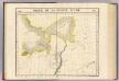
Partie, Russie d'Asie. Asie 5.
1 : 1641836 Vandermaelen, Philippe, 1795-1869
Merkatorskaja karta rěk
Ilyč, řeka (Rusko) Krusenstern, Paul Theodor von
Partie, Russie d'Asie. Asie 12.
1 : 1641836 Vandermaelen, Philippe, 1795-1869
Dwinæ fluvii nova descriptio
1 : 640000 1 Karte in 3 Teilen auf 1 Blatt : Kupferdruck ; 46 x 54 cm Janssonius van Waesbergen, Johannes sumptibus Janssonio-Waesbergiorum et Mosis Pitt
FRETVM NASSOVIVM | Vulgo | DE STRAET NASSOV.
[engraver: Corneel Muller] [Amsterdam : Joan Blaeu]
I. ORDINVM | Vulgo | STATEN EYLAND.
[engraver: Frans Hogenberg] [Amsterdam : Joan Blaeu]
I. MAVRITIVS.
[Amsterdam : Joan Blaeu]
Geologičeskaja karta Evropejskoj Rossii
1 : 2500000 Nordost-Blatt Karpinskij, A.P. (Aleksandr Petrovič) Kartografičeskoe zavedenie A.Il'ina
(Europaischen Russland II).
1 : 5000000 Berghaus, Heinrich; Flemming, Carl; Handtke, Friedrich H.; Sohr, Karl
[Ost-Europa in 6 Blättern, Enthaltend: Norwegen, Schweden, Russland, Kaukasien und die Türkei, Blatt 2]
Hand-Atlas über alle Theile der Erde und über das Weltgebäude Stieler, Adolf Justus Perthes
Russie d'Europe / par J.B. Poirson Ingénieur Géog.e
1 : 10000000 1 Karte : Kupferdruck ; 18 x 24 cm Poirson, Jean-Baptiste [Verlag nicht ermittelbar]
Carte de la Russie d'Europe / par J.B. Poirson ; gravé par Tardieu
1 : 9000000 1 Karte auf 2 Blatt : Kupferdruck ; 39 x 27 cm Poirson, Jean-Baptiste [Mentelle]
[Ost-Europa, Blatt 2]
Adolf Stieler's Handatlas über alle Theile der Erde und über das Weltgebäude Stieler, Adolf Justus Perthes
[Ost-Europa in 6 Blättern, Blatt 2]
Handatlas über alle Theile der Erde und über das Weltgebäude Stieler, Adolf Justus Perthes
Carte generale de toute l'Europe, 3
1 Blatt : 57 x 48 cm J.M. Will
Carte de La Russie D'Europe.
1 : 6700000 Vivien de St Martin, L.
Administrativnaja Karta Evropejskoj časti C.C.C.P.

Russia in Europe. Part II.
1 : 4500000 Society for the Diffusion of Useful Knowledge (Great Britain)
Russiae, vulo Moscovia dictae, Partes Septentrionalis et Orientalis. [Karte], in: Le théâtre du monde, ou, Nouvel atlas contenant les chartes et descriptions de tous les païs de la terre, Bd. 1, S. 70.
1 Karte aus Atlas Blaeu, Willem Janszoon und Blaeu, Joan Blaeu, Willem Janszoon