Maps of Kola Peninsula

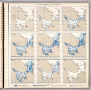
Ice Charts, White Sea (Beloye More). October - June.
U.S. Navy
Carte de la Mer Blanche
1 : 2900000 1 Karte : Kupferdruck ; 21 x 16 cm Bellin, Jacques Nicolas [Bellin]
Paskaart van de Witte Zee
1 : 710000 1 Karte : Kupferdruck ; 51 x 58 cm Keulen, Johannes van by Iohannis Van Keulen
Aus dem Cholmoger Kreise des Gouv. Archangelsk
Russland Archangelsk
Übersichtskarte Karelien-Kola
1 : 1000000 Karélie (Rusko) Generalstab des Heeres, Abteilung für Kriegskarten und Vermessungswesen
Mappæ imperii Moscovitici pars septentrionalis
1 Karte : Kupferdruck ; 48 x 56 cm Seutter; L'Isle Matthäus Seutter
Mappae imperii Moscovitici pars septentrionalis / adornata per Guillielmum de l'Isle membrum Academi
1 : 2600000 1 Karte : Kupferdruck ; 48 x 56 cm Seutter, Matthäus anjezo bey Johañ Michael Probst
Mappae imperii Moscovitici pars septentrionalis / adornata per Guillielmum de l'Isle membrum Academi
1 : 2600000 1 Karte : Kupferdruck ; 48 x 56 cm Seutter, Matthäus [Matthäus Seutter]
Finnmarchiae et Laplandiae Maritima

Feuille 12 (E II), uit: Carte géologique internationale de l'Europe : la carte, votée au congrès géologique international de Bologne en 1881, est exécutée conformément aux décisions d'une commission internationale, avec le concours des gouvernements, sous le dir. de M.M. Beyrich et Hauchecorne
Annotatie: Blad 48 gamme des couleurs; blad 49: bladwijzer en titelblad Heinrich Ernst Beyrich 1815-1896; Wi. Hauchecorne Berlin : Reimer / (Berlin: Institut lithographique)
No.16. Karta Evropeyskaia Rossiia. Sheet 2
1 : 2000000 Shokalskago,Iu. M.
Partie, Russie d'Europe. Europe 2.
1 : 1641836 Vandermaelen, Philippe, 1795-1869
Karelische Arbeiterkommune 1920
Karelien Kommune, Arbeiter Hösch, Riika
Karelische Autonome Sozialistische Sowjetrepublik 1923
Karelien, Karelische Autonome Sozialistische Sowjetrepublik Hösch, Riika
Dwinae Fluvii. nova descriptio. [Karte, Teil 1], in: Novus atlas absolutissimus, Bd. 1, S. 81.
1 Karte aus Atlas Janssonius Offizin
DWINA FLVVIVS.
[Amsterdam : Joan Blaeu]
Dwinæ fluvii nova descriptio
1 : 640000 1 Karte in 3 Teilen auf 1 Blatt : Kupferdruck ; 46 x 54 cm Janssonius van Waesbergen, Johannes sumptibus Janssonio-Waesbergiorum et Mosis Pitt
Moscovie (nord)
1 : 2600000 L'Isle, Guillaume de, 1675-1726
La Moscovie septentrionale, suivant les nouvelles observations de Messrs. de L'Académie Royale de S
1 : 5800000 1 Karte : Kupferdruck ; 21 x 29 cm chez Covens et Mortier
La Moscovie septentrionale, suivant les nouvelles observations de Messrs. de L'Académie Royale de S
1 : 5800000 1 Karte : Kupferdruck ; 21 x 29 cm chez Covens et Mortier
[IV], uit: Geognostische Karte des Oesterreichischen Kaiserstaates mit einem grossen Theile Deutschland's u. Italien / hauptsachlich nach ... Haidinger's geognostischer Karte dieses Staates bearb. von Josef Scheda
1 : 3000000 titelvariant: General-Karte von Europa in 25 Blättern; Annotatie: Bijlage bij: General-Karte von Europa in 25 Blättern. - 1:2.592.000. - 1845-1847 Scheda, Joseph Wien : K.K. Militär. Geografisch. Institut
Nouvelle carte des etats du grand duc de Moscovie en Europe partie sertentrionale [sic]
1 : 3700000 1 Karte : Kupferdruck ; 34 x 45 cm Châtelain, Zacharias [Verlag nicht ermittelbar]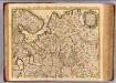
Moscovie.
1 : 2600000 L'Isle, Guillaume de, 1675-1726
Carte nouvelle de Moscovie / dressée par G. de L'Isle
1 : 3200000 1 Karte : Kupferdruck ; 40 x 55 cm L'Isle, Guillaume de chés Ian B. Elwe
16-17. RSFSR (Russian Soviet Federated Socialist Republic) in Europe, North. The World Atlas.
1 : 3000000 USSR (Union of Soviet Socialist Republics).
[Ost-Europa, Blatt 2]
Adolf Stieler's Handatlas über alle Theile der Erde und über das Weltgebäude Stieler, Adolf Justus Perthes
N. European ports.
1 : 10000000 Philip, George
Finmarchiæ et Laplandiæ maritima
1 Karte : Kupferdruck ; 49 x 55 cm Renard Louis Renard
Mappae Imperii Moscovitici pars Septentrionalis
1 : 2600000 adornata per Guillielmum De L'Isle nunc vero aeri incisa et venalis exposita a Matth. Seutter Aug. [Vindelicorum] : Matt. Seutter