Maps of Zapolyarny District

[IV], uit: Geognostische Karte des Oesterreichischen Kaiserstaates mit einem grossen Theile Deutschland's u. Italien / hauptsachlich nach ... Haidinger's geognostischer Karte dieses Staates bearb. von Josef Scheda
1 : 3000000 titelvariant: General-Karte von Europa in 25 Blättern; Annotatie: Bijlage bij: General-Karte von Europa in 25 Blättern. - 1:2.592.000. - 1845-1847 Scheda, Joseph Wien : K.K. Militär. Geografisch. Institut
[Ost-Europa in 6 Blättern, Enthaltend: Norwegen, Schweden, Russland, Kaukasien und die Türkei, Blatt 2]
Hand-Atlas über alle Theile der Erde und über das Weltgebäude Stieler, Adolf Justus Perthes
[Ost-Europa, Blatt 2]
Adolf Stieler's Handatlas über alle Theile der Erde und über das Weltgebäude Stieler, Adolf Justus Perthes
16-17. RSFSR (Russian Soviet Federated Socialist Republic) in Europe, North. The World Atlas.
1 : 3000000 USSR (Union of Soviet Socialist Republics).
Karta Pomorskago kraja v 17 věkě
Russland Russland (Nord)
Russia 2.
1 : 4435200 Letts, Son & Co.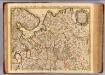
Moscovie.
1 : 2600000 L'Isle, Guillaume de, 1675-1726
Ost-Europa, Bl. 2: Nordost-Russland.
1 : 3700000 Petermann, A.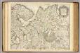
Moscovie (nord)
1 : 2600000 L'Isle, Guillaume de, 1675-1726
Carte nouvelle de Moscovie / dressée par G. de L'Isle
1 : 3200000 1 Karte : Kupferdruck ; 40 x 55 cm L'Isle, Guillaume de chés Ian B. Elwe

Mappæ imperii Moscovitici pars septentrionalis
1 Karte : Kupferdruck ; 48 x 56 cm Seutter; L'Isle Matthäus Seutter
Mappae imperii Moscovitici pars septentrionalis / adornata per Guillielmum de l'Isle membrum Academi
1 : 2600000 1 Karte : Kupferdruck ; 48 x 56 cm Seutter, Matthäus anjezo bey Johañ Michael Probst
Mappae imperii Moscovitici pars septentrionalis / adornata per Guillielmum de l'Isle membrum Academi
1 : 2600000 1 Karte : Kupferdruck ; 48 x 56 cm Seutter, Matthäus [Matthäus Seutter]
Russiæ et Novæ Zemlæ maritimæ
1 Karte : Kupferdruck ; 48 x 56 cm Renard Louis Renard
Nouvelle carte des etats du grand duc de Moscovie en Europe partie sertentrionale [sic]
1 : 3700000 1 Karte : Kupferdruck ; 34 x 45 cm Châtelain, Zacharias [Verlag nicht ermittelbar]
Nördliches Eismeer Häfen in der Barentsee
Barentsovo moře Reichs-Marine-Amt
La Moscovie septentrionale, suivant les nouvelles observations de Messrs. de L'Académie Royale de S
1 : 5800000 1 Karte : Kupferdruck ; 21 x 29 cm chez Covens et Mortier
La Moscovie septentrionale, suivant les nouvelles observations de Messrs. de L'Académie Royale de S
1 : 5800000 1 Karte : Kupferdruck ; 21 x 29 cm chez Covens et Mortier
[128][131] Russiae et Novae Zemlae Maritimae, uit: Atlas sive Descriptio terrarum orbis
Annotatie: Gedigitaliseerde versie. Amsterdam. Heiloo : Picturae (vervaardiger), 2015. tiff-bestand. Gedigitaliseerd: 07-01-2015; Origineel: Universiteitsbibliotheek Vrije Universiteit (XL.05127.-) ; Netherlands; Titelpagina ontbreekt Wit, Frederik de Amsterdam : Frederick de Wit
Geognostisch-geographische Übersicht des Petschora Landes
Pečora, řeka (Rusko) Keyserling, Alexander Krusenstern, Paul von
Geognostisch-geographische Übersicht des Petschora Landes
Pečora, řeka (Rusko) Keyserling, Alexander Krusenstern, Paul von
Übersichtskarte Karelien-Kola
1 : 1000000 Karélie (Rusko) Generalstab des Heeres, Abteilung für Kriegskarten und Vermessungswesen
No.17. Karta Evropeyskaia Rossiia. Sheet 3
1 : 2000000 Shokalskago,Iu. M.
Governo di Arcangelo, e sue provincie nella Russia europea / G. Zuliani inc. ; G. Pitteri scr
1 : 3500000 1 Karte : Kupferdruck ; 42 x 33 cm Zuliani, Giuliano presso Antonio Zatta
Feuille 12 (E II), uit: Carte géologique internationale de l'Europe : la carte, votée au congrès géologique international de Bologne en 1881, est exécutée conformément aux décisions d'une commission internationale, avec le concours des gouvernements, sous le dir. de M.M. Beyrich et Hauchecorne
Annotatie: Blad 48 gamme des couleurs; blad 49: bladwijzer en titelblad Heinrich Ernst Beyrich 1815-1896; Wi. Hauchecorne Berlin : Reimer / (Berlin: Institut lithographique)
Feuille 5 (E I), uit: Carte géologique internationale de l'Europe : la carte, votée au congrès géologique international de Bologne en 1881, est exécutée conformément aux décisions d'une commission internationale, avec le concours des gouvernements, sous le dir. de M.M. Beyrich et Hauchecorne
Annotatie: Blad 48 gamme des couleurs; blad 49: bladwijzer en titelblad Heinrich Ernst Beyrich 1815-1896; Wi. Hauchecorne Berlin : Reimer / (Berlin: Institut lithographique)
Partie, Russie d'Europe. Europe 2.
1 : 1641836 Vandermaelen, Philippe, 1795-1869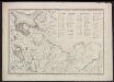
Voenno-dorožnaja karta časti Rossii i pograničnych zemelʹ
1 : 1680000 Karelien, Pomor'e Šubert [Generalmajor]
MAPPAE IMPERII MOSCOVITICI
1 : 2900000 Moskva-oblast (Rusko) Delisle, Guillaume Seutter, Matthäus a Matth. Seutter
Mappae imperii Moscovitici
1 : 2900000 Moskva-oblast (Rusko) Delisle, Guillaume Seutter, Matthäus a Matth. Seutter
![[IV], uit: Geognostische Karte des Oesterreichischen Kaiserstaates mit einem grossen Theile Deutschland's u. Italien / hauptsachlich nach ... Haidinger's geognostischer Karte dieses Staates bearb. von Josef Scheda](https://images-2.georeferencer.com/images/iiif/117552960372/full/,300/0/native.jpg)

