Maps of Karelia

MAPPAE IMPERII MOSCOVITICI
1 : 2900000 Moskva-oblast (Rusko) Delisle, Guillaume Seutter, Matthäus a Matth. Seutter
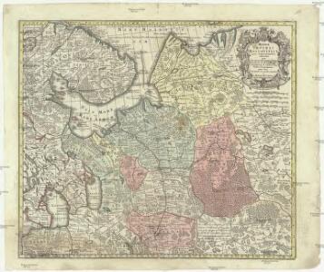
Mappae imperii Moscovitici
1 : 2900000 Moskva-oblast (Rusko) Delisle, Guillaume Seutter, Matthäus a Matth. Seutter
Mappae imperii Moscovitici
1 : 2900000 Moskva-oblast (Rusko) Delisle, Guillaume Seutter, Matthäus M. Seutter
Feuille 12 (E II), uit: Carte géologique internationale de l'Europe : la carte, votée au congrès géologique international de Bologne en 1881, est exécutée conformément aux décisions d'une commission internationale, avec le concours des gouvernements, sous le dir. de M.M. Beyrich et Hauchecorne
Annotatie: Blad 48 gamme des couleurs; blad 49: bladwijzer en titelblad Heinrich Ernst Beyrich 1815-1896; Wi. Hauchecorne Berlin : Reimer / (Berlin: Institut lithographique)
Voenno-dorožnaja karta časti Rossii i pograničnych zemelʹ
1 : 1680000 Karelien, Pomor'e Šubert [Generalmajor]
Übersichtskarte Karelien-Kola
1 : 1000000 Karélie (Rusko) Generalstab des Heeres, Abteilung für Kriegskarten und Vermessungswesen
Karelische Arbeiterkommune 1920
Karelien Kommune, Arbeiter Hösch, Riika
Karelische Autonome Sozialistische Sowjetrepublik 1923
Karelien, Karelische Autonome Sozialistische Sowjetrepublik Hösch, Riika
Karta ozernoj oblasti
Russland Russland (Nord) Il'in', N.
[Nordrussland ; Vieh]
Russland Russland (Nord) Landwirtschaft
[Nordrussland ; Vieh]
Russland Russland (Nord) Landwirtschaft
[Nordrussland ; Pferd]
Russland Russland (Nord) Landwirtschaft
Itäinen Aunus
1 : 1000000 Olonec (Rusko : oblast) Tilgmannin kivipaino
[Nordrussland ; Pferd]
Russland Russland (Nord) Landwirtschaft
Partie, Russie d'Europe. Europe 5.
1 : 1641836 Vandermaelen, Philippe, 1795-1869
Partie, Russie d'Europe. Europe 6.
1 : 1641836 Vandermaelen, Philippe, 1795-1869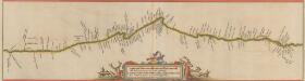
Dwinae Fluvii. nova descriptio. [Karte, Teil 2], in: Novus atlas absolutissimus, Bd. 1, S. 81.
1 Karte aus Atlas Janssonius Offizin
Dwinæ fluvii nova descriptio
1 : 640000 1 Karte in 3 Teilen auf 1 Blatt : Kupferdruck ; 46 x 54 cm Janssonius van Waesbergen, Johannes sumptibus Janssonio-Waesbergiorum et Mosis Pitt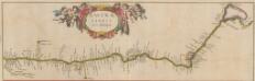
Dwinae Fluvii. nova descriptio. [Karte, Teil 1], in: Novus atlas absolutissimus, Bd. 1, S. 81.
1 Karte aus Atlas Janssonius Offizin
Paskaart van de Witte Zee
1 : 710000 1 Karte : Kupferdruck ; 51 x 58 cm Keulen, Johannes van by Iohannis Van Keulen
DWINA FLVVIVS.
[Amsterdam : Joan Blaeu]
St. Petersburg, Tichwin
1 : 750000 Petrohrad (Rusko) K. u. k. Militärgeographisches Institut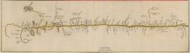
Dwinae Fluvii. nova descriptio. [Karte, Teil 3], in: Novus atlas absolutissimus, Bd. 1, S. 81.
1 Karte aus Atlas Janssonius Offizin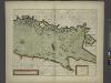
The coast of LYF LAND and East FINLAND from Wolf to Wybourgh and soto Elsenvos
from The sea-atlas : containing an hydrographical description of most of the sea-coasts of the known parts of the world.
Carte de la Mer Blanche
1 : 2900000 1 Karte : Kupferdruck ; 21 x 16 cm Bellin, Jacques Nicolas [Bellin]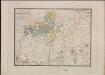
Ethnographische Karte des St. Petersburgischen Gouvernements
Gouvernement Sankt Petersburg Ethnische Gruppe, Bevölkerung Keppen, Petr I.
General'naja Karta Sanktpeterburgskoj Gubernii
1 : 1125000 composé et gravée par Piadicheff les leteres grav. M. Iwanoff St. Petersbourg, [s.n.]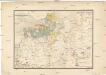
Etnographische Karte des St. Petersburgischen Gouvernements
1 : 1300000 Petrohrad-oblast (Rusko) Koeppen, P. von K. Akademie der Wissenschaften zu St. Peterburg
Province de St. Petersbourg
1 : 840000 [St. Petersbourg] : [A. Iljin]