Maps of powiat elbląski

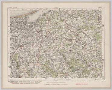
Elbing 27, uit: Special-Karte von Mittel-Europa / nach amtlichen Quellen bearbeitet von W. Liebenow
1 : 300000 titelvariant: W. Liebenow's Mittel-Europa; Annotatie: Titel boven de bladen: W. Liebenow's Mittel-Europa Johannes Wilhelm Liebenow 1822-1897 Frankfurt a. M. : Ludwig Ravenstein
Tabvla geographica episcopatvm Warmiensem in Prvssia exhibens, Heilsberg, solita habitatio episcopalis, longitudinem 38. graduum, et 16. minutorum ab insula Ferro numerat
1 : 220000 Lidzbark Warmiński-oblast (Polsko) Endersch, Johann Friedrich Grabowski, Adam Stanisław Ioannes Fridericus Endersch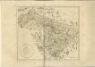

Karte von Ermeland oder zweites Blat von Westpreussen
1 : 225000 Prusko Západní Endersch, Johann Friedrich Amon, Anton F.A. Schraembl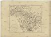
Karte von Ermeland oder zweites Blat von Westpreussen
1 : 225000 Prusko Západní Endersch, Johann Friedrich Amon, Anton F.A. Schraembl
Karte von Ermeland oder zweites Blat von Westpreussen
1 : 225000 Prusko Západní Endersch, Johann Friedrich Amon, Anton F.A. Schraembl
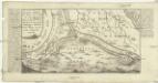
Tractuum Borussiae, circa Gedanum et Elbingam, ab incolis Werder appellati, cum adiuncta Neringia, nova et elaboratissima delineatio [Karte], in: Novus atlas absolutissimus, Bd. 1, S. 110.
1 Karte aus Atlas Janssonius Offizin
Mappa geographica trivm insvlarvm in Prvssia, qvae Poloniarvm regi serenissimo paret, accvratissima, in qva Gedanensis emporii longitudo 36. gradus et 21. minuta ab insvla Ferro connumeratur
1 : 140000 Gdaňsk-oblast (Polsko) Endersch, Johann Friedrich Brühl, Heinrich von Ioannes Fridericus Endersch
TRACTVVM BORVSSIÆ, | circa Gedanum et Elbingam, | ab incolis WERDER appellati; cum | adiuncta NERINGIA, nova et | elaboratissima delineatio
Authore Olao Ioannis Gotho. [Amsterdam : Joan Blaeu]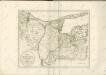

73. Heiligenbeil. (Germany)
1 : 100000 Reichsamt fur Landesaufnahme
Karte von Danzig, Elbing, und Marienburg oder erstes Blat von Westpreussen
1 : 137000 Elbląg (Polsko) Endersch, Johann Friedrich Amon, Anton F.A. Schraembl
Karte von Danzig, Elbing, und Marienburg oder erstes Blat von Westpreussen
1 : 137000 Elbląg (Polsko) Endersch, Johann Friedrich Amon, Anton F.A. Schraembl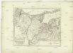
Karte von Danzig, Elbing, und Marienburg oder erstes Blat von Westpreussen
1 : 137000 Elbląg (Polsko) Endersch, Johann Friedrich Amon, Anton F.A. Schraembl
Karte von Danzig, Elbing, und Marienburg oder erstes Blat von Westpreussen
1 : 137000 Elbląg (Polsko) Endersch, Johann Friedrich Amon, Anton F.A. Schraembl
Composite: 102. Wormditt. (Germany)
1 : 100000 Reichsamt fur Landesaufnahme
Composite: 132. Christburg. (Germany)
1 : 100000 Reichsamt fur Landesaufnahme
Composite: 133. Mohrungen. (Germany)
1 : 100000 Reichsamt fur Landesaufnahme
102. Wormditt. (Germany)
1 : 100000 Reichsamt fur Landesaufnahme
Composite: 100. Marienburg. (Germany)
1 : 100000 Reichsamt fur Landesaufnahme
Composite: 131. Stuhm. (Germany)
1 : 100000 Reichsamt fur Landesaufnahme
Composite: 101. Elbing. (Germany)
1 : 100000 Reichsamt fur Landesaufnahme
100. Marienburg. (Germany)
1 : 100000 Reichsamt fur Landesaufnahme
101. Elbing. (Germany)
1 : 100000 Reichsamt fur Landesaufnahme
131. Stuhm. (Germany)
1 : 100000 Reichsamt fur Landesaufnahme
Composite: 71. Tiegenort. (Germany)
1 : 100000 Reichsamt fur Landesaufnahme
Composite: 72. Frauenburg. (48. Gr. Bruch) (Germany)
1 : 100000 Reichsamt fur Landesaufnahme
165. Deutsch-Eylau. (Germany)
1 : 100000 Reichsamt fur Landesaufnahme
71. Tiegenort. (Germany)
1 : 100000 Reichsamt fur Landesaufnahme