Maps of gmina Tczew
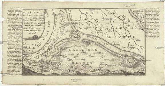
Eigentliche Abbildung wie A. 1657. den 27. Febr. die Schweden den Weixel Damm durchstochen u. den ganzen Dantziger Werder unter Wasser gesetzt, samt umliegender Gegend
Gdaňsk-oblast (Polsko) Bodenehr, Gabriel G. Bodenehr excudit
Prospect Grundris und Gegend der Polnischen vesten Reichs und Handels-Stadt Dantzig und ihrem Werder
1 : 6600 Homann, Johann Baptist, 1663-1724 Io. Bapt. Homann
Composite: 71. Tiegenort. (Germany)
1 : 100000 Reichsamt fur Landesaufnahme
Composite: 99. Dirschau. (Germany)
1 : 100000 Reichsamt fur Landesaufnahme
Composite: 100. Marienburg. (Germany)
1 : 100000 Reichsamt fur Landesaufnahme
100. Marienburg. (Germany)
1 : 100000 Reichsamt fur Landesaufnahme
Composite: 163. Neuenburg. (Germany)
1 : 100000 Reichsamt fur Landesaufnahme
Die Stadt Dantzig mit ihren Gebiet und einigen umliegenden Gegenden
1 : 95000 Gdaňsk-oblast (Polsko)
Plan von der Gegend um Danzig im Anfange des Jahres 1807
1 : 25500 Gdaňsk-oblast (Polsko) Engelhardt, F.B. Gall, Carl Carl Gall
Plan de la celebre ville marchande de Dantzig, et de ses environs
1 : 67000 Gdaňsk-oblast (Polsko) Homann, Johann Baptist par J. Cóvens et C. Mortier
Meßtischblatt 1979 : Gnojau, 1940
1 : 250000 Gnojau. - Aufn. 1904, hrsg. 1906, bericht. 1909, letzte Na. - 1:25000. - [Berlin]: Reichsamt für Landesaufnahme, 1940. - 1 Kt.
Meßtischblatt 624 : Gnojau, 1906
1 : 250000 Gnojau. - Aufn. 1904. - 1:25000. - [Berlin]: Reichsamt für Landesaufnahme, 1906. - 1 Kt.
Meßtischblatt 1978 : Dirschau, 1936
1 : 250000 Dirschau. - Hrsg. 1910, Nachtr. 1925. - 1:25000. - [Berlin]: Reichsamt für Landesaufnahme, 1936. - 1 Kt.
Meßtischblatt 541 : Gr. Lichtenau, 1925
1 : 250000 Gr. Lichtenau. - Aufn. 1898, bericht. 1909, Nachtr. 1925. - 1:25000. - [Berlin]: Reichsamt für Landesaufnahme, 1925. - 1 Kt.
Meßtischblatt 541 : Gr. Lichtenau, 1900
1 : 250000 Gr. Lichtenau. - Aufn. 1898. - 1:25000. - [Berlin]: Reichsamt für Landesaufnahme, 1900. - 1 Kt.
Meßtischblatt 1878 : Mühlbanz, 1940
1 : 250000 Mühlbanz. - Aufn. 1908, bericht. 1909, hrsg. 1910, letzte Na. - 1:25000. - [Berlin]: Reichsamt für Landesaufnahme, 1940. - 1 Kt.
Meßtischblatt 540 : Mühlbanz, 1925
1 : 250000 Mühlbanz. - Aufn. 1908, bericht. 1909, Nachtr. 1925. - 1:25000. - [Berlin]: Reichsamt für Landesaufnahme, 1925. - 1 Kt.
Meßtischblatt 464 : Schöneberg, 1925
1 : 250000 Schöneberg. - Aufn. 1908, Nachtr. 1925. - 1:25000. - [Berlin]: Reichsamt für Landesaufnahme, 1925. - 1 Kt.
Meßtischblatt 178 : Trutenau, 1942
1 : 250000 Trutenau. - Aufn. 1908, hrsg. 1910, letzte Nachtr. 1936. - 1:25000. - [Berlin]: Reichsamt für Landesaufnahme, 1942. - 1 Kt.
Meßtischblatt 1679 : Nickelswalde, 1936
1 : 250000 Nickelswalde. - Aufn. 1908, hrsg. 1910, letzte Nachtr. 1925. - 1:25000. - [Berlin]: Reichsamt für Landesaufnahme, 1936. - 1 Kt.
Meßtischblatt 392 : Weichselmünde, 1929
1 : 250000 Weichselmünde. - Aufn. 1908, Nachtr. 1929. - 1:25000. - [Berlin]: Reichsamt für Landesaufnahme, 1929. - 1 Kt.
Danzig und Umgegend
1 : 200000 Danzig, Umland
Danzig und Umgegend
1 : 370000 Danzig, Umland
Plan der Stadt und Gegend von Dantzig nebst dem Ausflus der Weichsel
1 : 30000 Augsburg : in Verlag Tob. Conr. Lotter
Plan der Stadt und Gegend von Dantzig nebst dem Ausflus der Weichsel
1 : 30000 Gdaňsk-oblast (Polsko) Lotter, Tobias Conrad Tob. Conr. Lotter
Die königl. polnische u. preusische Hansee- und Handels-Stadt Dantzig, poln. Gdansko, im Lande Pomerellien, in der Lange 36°21' und in der Breite 54°24', in einem richtigen Plan und Prospect nebst Anzeige der ruß-saechßischen Belagerung A. 1734
Gdaňsk (Polsko) von Homaenischen Erben
Übersicht der Befestigung von Danzig und Weichselmünde
1 : 20833 Annotatie: Rechtboven: Skizze 7; Uit Bd. 4 van: Der Krieg von 1806 und 1807 / O. von Lettow-Vorbeck. - Berlin : Mittler, 1896; Fotogr. reprod. van origineel uit: Der Krieg von 1806 und 1807 ... / E. von Höpfner. - Berlin : Schropp, 1850 Berlin : Mittler
DANTISCUM s. Gedanum celeberrimum, spatiosum et munitum Emporium ac Hanseatica Civitas ad Ostia Vistulae, in Polonia Borußica in Provincia Pomerellia sita
Gdaňsk (Polsko) Seutter, Matthäus per Matthaeum Seutter
[Gdaňsk]
Gdaňsk (Polsko) Bodenehr, Gabriel G. Bodenehr