Maps of powiat nowodworski

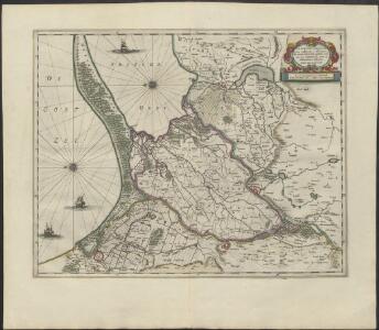
TRACTVVM BORVSSIÆ, | circa Gedanum et Elbingam, | ab incolis WERDER appellati; cum | adiuncta NERINGIA, nova et | elaboratissima delineatio
Authore Olao Ioannis Gotho. [Amsterdam : Joan Blaeu]
Tractuum Borussiae, circa Gedanum et Elbingam, ab incolis Werder appellati, cum adiuncta Neringia, nova et elaboratissima delineatio [Karte], in: Novus atlas absolutissimus, Bd. 1, S. 110.
1 Karte aus Atlas Janssonius Offizin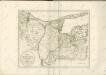

Karte von Danzig, Elbing, und Marienburg oder erstes Blat von Westpreussen
1 : 137000 Elbląg (Polsko) Endersch, Johann Friedrich Amon, Anton F.A. Schraembl
Karte von Danzig, Elbing, und Marienburg oder erstes Blat von Westpreussen
1 : 137000 Elbląg (Polsko) Endersch, Johann Friedrich Amon, Anton F.A. Schraembl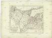
Karte von Danzig, Elbing, und Marienburg oder erstes Blat von Westpreussen
1 : 137000 Elbląg (Polsko) Endersch, Johann Friedrich Amon, Anton F.A. Schraembl
Karte von Danzig, Elbing, und Marienburg oder erstes Blat von Westpreussen
1 : 137000 Elbląg (Polsko) Endersch, Johann Friedrich Amon, Anton F.A. Schraembl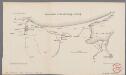
Übersichtsblatt der Einschliessung von Danzig
1 : 200000 Annotatie: Rechtboven: Skizze 6; Uit Bd. 4 van: Der Krieg von 1806 und 1807 / O. von Lettow-Vorbeck. - Berlin : Mittler, 1896; Fotogr. reprod. van origineel uit: Der Krieg von 1806 und 1807 ... / E. von Höpfner. - Berlin : Schropp, 1850 Berlin : Mittler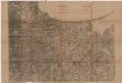
Gdańsk
Polen Danzig Gdansk Grenze Wierzbicki, B.
Mappa geographica trivm insvlarvm in Prvssia, qvae Poloniarvm regi serenissimo paret, accvratissima, in qva Gedanensis emporii longitudo 36. gradus et 21. minuta ab insvla Ferro connumeratur
1 : 140000 Gdaňsk-oblast (Polsko) Endersch, Johann Friedrich Brühl, Heinrich von Ioannes Fridericus Endersch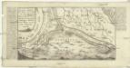
Eigentliche Abbildung wie A. 1657. den 27. Febr. die Schweden den Weixel Damm durchstochen u. den ganzen Dantziger Werder unter Wasser gesetzt, samt umliegender Gegend
Gdaňsk-oblast (Polsko) Bodenehr, Gabriel G. Bodenehr excudit
Composite: 71. Tiegenort. (Germany)
1 : 100000 Reichsamt fur Landesaufnahme
Prospect Grundris und Gegend der Polnischen vesten Reichs und Handels-Stadt Dantzig und ihrem Werder
1 : 6600 Homann, Johann Baptist, 1663-1724 Io. Bapt. Homann
71. Tiegenort. (Germany)
1 : 100000 Reichsamt fur Landesaufnahme
Composite: 100. Marienburg. (Germany)
1 : 100000 Reichsamt fur Landesaufnahme
100. Marienburg. (Germany)
1 : 100000 Reichsamt fur Landesaufnahme
101. Elbing. (Germany)
1 : 100000 Reichsamt fur Landesaufnahme
48. Gr. Bruch. (72. Frauenburg) (Germany)
1 : 100000 Reichsamt fur Landesaufnahme
Composite: 101. Elbing. (Germany)
1 : 100000 Reichsamt fur Landesaufnahme
Grundriss der Stadt Dantzig : nebst ihren umliegenden Gegenden und dem Ausfluss der Weischsel in dei Ostsee nach einer genauen Aufnahme des Terrains zusammengetragen und angefertiget
1 : 86921 Sotzmann, D. F s.n.
Composite: 131. Stuhm. (Germany)
1 : 100000 Reichsamt fur Landesaufnahme
131. Stuhm. (Germany)
1 : 100000 Reichsamt fur Landesaufnahme
Composite: 163. Neuenburg. (Germany)
1 : 100000 Reichsamt fur Landesaufnahme
Meßtischblatt 2083 : Miswalde, 1938
1 : 250000 Miswalde. - Hrsg. 1911, bericht. 1930, redakt. Änd. 1938. - 1:25000. - [Berlin]: Reichsamt für Landesaufnahme, 1938. - 1 Kt.
Meßtischblatt 2082 : Christburg, 1930
1 : 250000 Christburg. - Hrsg. 1911, bericht. 1930. - 1:25000. - [Berlin]: Reichsamt für Landesaufnahme, 1930. - 1 Kt.
Meßtischblatt 2080 : Stuhm, 1938
1 : 250000 Stuhm. - Hrsg. 1906, einz. Nachtr. 1928, redakt. Änd. 193. - 1:25000. - [Berlin]: Reichsamt für Landesaufnahme, 1938. - 1 Kt.
Meßtischblatt Wernersdorf
1 : 250000 Wernersdorf. - Hrsg. 1906, bericht. 1928. - 1:25000. - [Berlin]: Reichsamt für Landesaufnahme, 1928. - 1 Kt.
Meßtischblatt 2081 : Gr. Waplitz, 1929
1 : 250000 Gr. Waplitz. - Hrsg. 1906, einz. Nachtr. 1929. - 1:25000. - [Berlin]: Reichsamt für Landesaufnahme, 1929. - 1 Kt.
Meßtischblatt 2078 : Pelplin, 1940
1 : 250000 Pelplin. - Aufn. 1904/08, hrsg. 1910, letzte Nachtr. 1929. - 1:25000. - [Berlin]: Reichsamt für Landesaufnahme, 1940. - 1 Kt.