Maps of Great Rift Valley
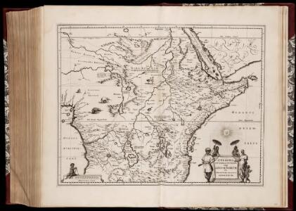
Æthiopia superior vel interior; vulgo Abissinorum sive presbiteri Ioannis Imperium
1 : 12500000 Annotatie: Kaart uitg. in de periode ca. 1688-ca. 1700; Origineel is Blad 210 in atlas factice; Annotatie geografische gegevens: Schaalstok op kaart: 100 Milliaria Germanica communia (=6,1 cm) [Amsterdam] : [F. de Wit]
Aethiopia Superior vel Interior; vulgo Abissinorum sive Presbiteri Ioannis Imperium. [Karte], in: Gerardi Mercatoris et I. Hondii Newer Atlas, oder, Grosses Weltbuch, Bd. 2, S. 373.
1 Karte aus Atlas Mercator, Gerhard und Hondius, Jodocus Jansson, Jan
Charte der Nordküste Africas, oder die staaten Maroccos, Fes, Algier, Tunis, Tripoli, und Aegypten : nach den neuesten und besten Hülfsmitteln
1 : 5000000 Reinecke, J. C. M. (Johann Christoph Matthias), 1770-1818 Verlage des Landes Indust. Compt.
Aethiopia Superior vel Interior; vulgo Abissinorum sive Presbiteri Ioannis Imperium. [Karte], in: Novus atlas absolutissimus, Bd. 6, S. 183.
1 Karte aus Atlas Janssonius Offizin
Abissinorum Sive Pretiosi Ioanis Imperium. [Karte] Congi Regni in Africa Christiani Nova descriptio. [Nebenkarte], in: Gerardi Mercatoris Atlas, sive, Cosmographicae meditationes de fabrica mundi et fabricati figura, S. 505.
1 Karte aus Atlas Mercator, Gerhard Montanus, Petrus
Aethiopia Superior vel Interior; vulgo Abissinorum sive Presbiteri Ioannis Imperium. [Karte], in: Le théâtre du monde, ou, Nouvel atlas contenant les chartes et descriptions de tous les païs de la terre, Bd. 2, S. 292.
1 Karte aus Atlas Blaeu, Willem Janszoon und Blaeu, Joan Blaeu, Willem Janszoon
Presbiteri Iohannis, Sive, Abissinorum imperii Descriptio. [Karte], in: Theatrum orbis terrarum, S. 415.
1 Karte aus Atlas Ortelius, Abraham Vrients, Jan Baptista

Presbiteri Iohannis, Sive, Abissinorum imperii Descriptio. [Karte], in: Theatrum orbis terrarum, S. 314.
1 Karte aus Atlas Ortelius, Abraham
Aethiopia Superior vel Interior; vulgo Abissinorum sive Presbiteri Ioannis Imperium [Karte], in: Novus Atlas, das ist, Weltbeschreibung, Bd. 2, S. 252.
1 Karte aus Atlas Blaeu, Joan Blaeu, Willem Janszoon
Aethiopia Superior vel Interior; vulgo Abissinorum sive Presbiteri Ioannis Imperium. [Karte], in: Theatrum orbis terrarum, sive, Atlas novus, Bd. 2, S. 301.
1 Karte aus Atlas Blaeu, Joan Blaeu, Willem Janszoon
Haute Ethiopie, où sont l’Empire des Abissins
Haute Ethiopie, où sont l'Empire des Abissins ... et le Zanguebar.
ÆTHIOPA | SVPERIOR vel INTERIOR; | vulgo | ABISSINORVM | sive | PRESBITERI IOANNIS | IMPERIVM.
[Amsterdam : Joan Blaeu]
Stanley in Africa
1 : 9500000 Ravenstein, E.G. Georg Philip & Son
Africa (Northeast Part). Africa (Central Part).
1 : 12070000 Hammond, C.S.
Africa et Arabia
Schul-Atlas der alten Welt bei Justus Perthes
Central & Southern Africa.
1 : 12000000 John Bartholomew and Son
Uebersichts-Karte der ethnographischen Verhältnisse von Asien und von den angrenzenden Theilen Europa'sbearbeitet und herausgegeben mit Unterstützung der kaiserlichen Akademie der Wissenschaften in Wien von Vinzenz v. Haardt
Hartenthurn, Vincenz
Southern Africa.
1 : 13600000 Bowen, Emanuel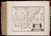
Æthiopia Inferior, vel Exterior : partes magis septentrionales, quæ hic desiderantur, vide in tabula Ethiopiæ Superioris
1 : 8300000 Annotatie: Origineel is Blad 212 in atlas factice; Annotatie geografische gegevens: Met schaalstok: [75] Milliaria Germanica (=6,5 cm) [Amsterdam : Willem en Johan Blaeu]
[Afrika, Blatt 4]
Adolf Stieler's Handatlas über alle Theile der Erde und über das Weltgebäude Stieler, Adolf Justus Perthes
170-171. Africa, Equatorial. The World Atlas.
1 : 7500000 USSR (Union of Soviet Socialist Republics).

Inner Afrika. nach dem gegenwartigen stande der erforschung
1 : 17000000 Riemer, C.; Geographisches Institut. Weimar, Allemagne Weimar : Geographisches Institut
Das Nordöstliche Africa
1 : 8000000 Afrika severovýchodní Lejean, Guillaume Marie Gräf, Adolph Geographisches Institut
Das Nordöstliche Africa
1 : 8000000 Afrika severovýchodní Lejean, Guillaume Marie Gräf, Adolph Geographisches Institut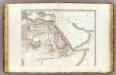
L'Afrique 2.
1 : 10000000 Brue, Adrien Hubert, 1786-1832
Oest. Hoch-Africa.
1 : 7500000 Weiland, C. F. (Carl Ferdinand), d. 1847
Riemer's Karte von Inner-Afrika
Afrika střední Riemer, C. Geographisches Institut