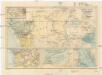
Maps of Great Rift Valley
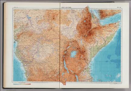
170-171. Africa, Equatorial. The World Atlas.
1 : 7500000 USSR (Union of Soviet Socialist Republics).
ÆTHIOPA | SVPERIOR vel INTERIOR; | vulgo | ABISSINORVM | sive | PRESBITERI IOANNIS | IMPERIVM.
[Amsterdam : Joan Blaeu]
Stanley in Africa
1 : 9500000 Ravenstein, E.G. Georg Philip & Son
Haute Ethiopie, où sont l’Empire des Abissins
Haute Ethiopie, où sont l'Empire des Abissins ... et le Zanguebar.

Aethiopia Superior vel Interior; vulgo Abissinorum sive Presbiteri Ioannis Imperium [Karte], in: Novus Atlas, das ist, Weltbeschreibung, Bd. 2, S. 252.
1 Karte aus Atlas Blaeu, Joan Blaeu, Willem Janszoon
[Afrika, Blatt 4]
Adolf Stieler's Handatlas über alle Theile der Erde und über das Weltgebäude Stieler, Adolf Justus Perthes
Afrique centrale. Congo-Nil
1 : 8000000 Niox, Gustave-Léon 1840-1921 Paris : Ch. Delagrave
Karte von Central-Afrika. Nach den neuesten Forschungen bearbeitet von Dr. Joseph Chavanne.

Riemer's Karte von Inner-Afrika
Afrika střední Riemer, C. Geographisches Institut
Oest. Hoch-Africa.
1 : 7500000 Weiland, C. F. (Carl Ferdinand), d. 1847
Inner Afrika. nach dem gegenwartigen stande der erforschung
1 : 17000000 Riemer, C.; Geographisches Institut. Weimar, Allemagne Weimar : Geographisches Institut
Congo
1 : 15000000 1 mapa, col. Full d'un atles en llengua castellana no identificat, que conté mapes físics, polítics i sobre el servei de correus. Datat al 1890 aproximadament.
Carte politique de l'Afrique centrale
1 : 10000000 Afrika střední Institut National de géographie
Carte politique de l'Afrique centrale
1 : 10000000 Institut national de géographie. Belgique Bruxelles : Institut national de géographie
Croquis hydrographique de l'Afrique centrale
1 : 10000000 Institut national de géographie. Belgique Bruxelles : Institut national de géographie
Ethiopia, Somalia, Kenya, Uganda, Rwanda, Tanzania, Burundi. Pergamon World Atlas.
Polish Army Topography Service
Übersichtskarte zum Zuge der Emin Pascha - Entsatzexpedition quer durch Afrika
1 : 5800000 Afrika střední F.A. Brockhaus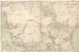
Central-Afrika
1 : 5000000 Afrika střední Chavanne, Joseph A. Hartleben's Verlag
Untitled
Central-Afrika mit dem internationalen Kongo-Gebiet
1 : 13000000 Afrika střední A. Hartleben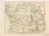
Äquatorial - Afrika

[Recto], uit: Congo physique, économique et administratif / dressé par A. Michiels
1 : 6000000 titelvariant: Nouvelle carte du Congo au 1:6.000.000; Notre colonie; Annotatie: Omslagtitel: Nouvelle carte du Congo au 1:6.000.000; Suppl. bij: Notre colonie : géographie et notice historique / Albert Michiels. - 4e éd. - Bruxelles : Mertens ; [etc.], 1913 Michiels, Albert Bruxelles : Mertens [etc.]
Evangelische Mission im Kwango, Rep ZaireUebersichtsplan der Gemeinden und Aussenposten im Bezug zur Siedlungsdichte

Congo Belge / comp. at the Royal Geographical Society under the dir. of the Geographical Section, General Staff ; drawn at the War Office
1 : 4000000 Royal Geographical Society, Verenigd Koninkrijk; General Staff, Verenigd Koninkrijk. Geographical Section; War Office, Verenigd Koninkrijk [S.l. : s.n.] / ([Bruxelles : I.C.M.])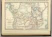
Central Africa.
1 : 10300000 Johnston, Alexander Keith
Inner-Afrika und der Kongo-Staat
1 : 8000000 Afrika střední Kettler, I. J. Geographisches Institut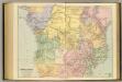
Central Africa.
1 : 5977362 Stanford, Edward