Maps of Africa

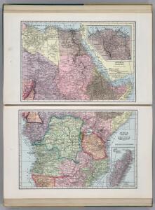
Africa (Northeast Part). Africa (Central Part).
1 : 12070000 Hammond, C.S.
Africa.
1 : 21500000 Gray, Ormando Willis
Africa
Atlas der evangelischen Missions-Gesellschaft zu Basel Locher; Gross, Rudolf Im Verlag des Comptoires der evangelischen Missions-Gesellschaft
Afrika von R. Andree und A. Scobel
1 : 10000000 Afrika Andree, Richard Scobel, Albert Velhagen & Klafing
Karte von Afrika
1 : 10000000 Andree, Richard Scobel, Albert Velhagen & Klasing
Karte von Africa zu C. F. Dambergers Reisen : nach Rennell's letzterer Charte von Nordafrica, Forsters Charte von Südafrica, Arrowsmith's beyden Weltcharten, auch Danville und Vaugondy &c.
1 : 25200000 von C. F. Goldbach [S.l.] : [s.n.]
Africa.
1 : 38000000 Lucas, Fielding Jr.
Africa.
1 : 4000000 Cummings, J. A. (Jacob Abbot)
Di-gyiu Du, Ng Da-tsiu Di-du[地舆图、五大洲地图]
Di-gyiu Du, Ng Da-tsiu Di-du[地舆图、五大洲地图] 1853年,Martin, W. A. P. (William Alexander Parsons) 美国长老会传教士丁韪良用罗马拼音标注宁波方言编写的世界地理著作,对地球和各大洲进行介绍。内有东西半球图、亚洲图、欧洲图、非洲图、北美洲图、南美洲图、地中海附近图、清内地十八省图、浙江省图、宁波附近图等。 10图,墨刻本,罗马拼音标注宁波方言,图幅不一,约39 x 49.5 cm Harvard-Yenching | Rare Book | TA 2370 92,Hollis Number:008156153
Charte der Nordküste Africas, oder die staaten Maroccos, Fes, Algier, Tunis, Tripoli, und Aegypten : nach den neuesten und besten Hülfsmitteln
1 : 5000000 Reinecke, J. C. M. (Johann Christoph Matthias), 1770-1818 Verlage des Landes Indust. Compt.
Central & Southern Africa.
1 : 12000000 John Bartholomew and Son
Æthiopia superior vel interior; vulgo Abissinorum sive presbiteri Ioannis Imperium
1 : 12500000 Annotatie: Kaart uitg. in de periode ca. 1688-ca. 1700; Origineel is Blad 210 in atlas factice; Annotatie geografische gegevens: Schaalstok op kaart: 100 Milliaria Germanica communia (=6,1 cm) [Amsterdam] : [F. de Wit]
萬國通鑑:亞非利加
美国传教士撰的向中国人介绍世界地理概况的著作,后有世界地图册1份,共13幅世界、大洲和区域地图,其中一幅题为《中國地圖》的清朝内地地图。 Sheffield, Devello Zelotos 謝衛樓 福州 : 美華書局
Costa oriental de Africa
1 : 25000000 1 mapa, col. Full d'un atles en llengua castellana no identificat, que conté mapes físics, polítics i sobre el servei de correus. Datat al 1890 aproximadament.
Composite: Africa.
1 : 5000000 John Bartholomew and Son
Presbiteri Iohannis, Sive, Abissinorum imperii Descriptio. [Karte], in: Theatrum orbis terrarum, S. 415.
1 Karte aus Atlas Ortelius, Abraham Vrients, Jan Baptista
Presbiteri Iohannis, Sive, Abissinorum imperii Descriptio. [Karte], in: Theatrum orbis terrarum, S. 314.
1 Karte aus Atlas Ortelius, Abraham
Aethiopia Superior vel Interior; vulgo Abissinorum sive Presbiteri Ioannis Imperium. [Karte], in: Gerardi Mercatoris et I. Hondii Newer Atlas, oder, Grosses Weltbuch, Bd. 2, S. 373.
1 Karte aus Atlas Mercator, Gerhard und Hondius, Jodocus Jansson, Jan

Haute Ethiopie, où sont l’Empire des Abissins
Haute Ethiopie, où sont l'Empire des Abissins ... et le Zanguebar.
Aethiopia Superior vel Interior; vulgo Abissinorum sive Presbiteri Ioannis Imperium. [Karte], in: Novus atlas absolutissimus, Bd. 6, S. 183.
1 Karte aus Atlas Janssonius Offizin
Abissinorum Sive Pretiosi Ioanis Imperium. [Karte] Congi Regni in Africa Christiani Nova descriptio. [Nebenkarte], in: Gerardi Mercatoris Atlas, sive, Cosmographicae meditationes de fabrica mundi et fabricati figura, S. 505.
1 Karte aus Atlas Mercator, Gerhard Montanus, Petrus
Aethiopia Superior vel Interior; vulgo Abissinorum sive Presbiteri Ioannis Imperium. [Karte], in: Le théâtre du monde, ou, Nouvel atlas contenant les chartes et descriptions de tous les païs de la terre, Bd. 2, S. 292.
1 Karte aus Atlas Blaeu, Willem Janszoon und Blaeu, Joan Blaeu, Willem Janszoon
Süd-Afrika & Madagaskar
Hand-Atlas über alle Theile der Erde und über das Weltgebäude Stieler, Adolf Justus Perthes
Southern Africa.
1 : 13600000 Bowen, Emanuel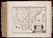
Æthiopia Inferior, vel Exterior : partes magis septentrionales, quæ hic desiderantur, vide in tabula Ethiopiæ Superioris
1 : 8300000 Annotatie: Origineel is Blad 212 in atlas factice; Annotatie geografische gegevens: Met schaalstok: [75] Milliaria Germanica (=6,5 cm) [Amsterdam : Willem en Johan Blaeu]
Aethiopia Superior vel Interior; vulgo Abissinorum sive Presbiteri Ioannis Imperium [Karte], in: Novus Atlas, das ist, Weltbeschreibung, Bd. 2, S. 252.
1 Karte aus Atlas Blaeu, Joan Blaeu, Willem Janszoon
Carte Generale de L'Afrique Meridionale.
1 : 18500000 Vivien de St Martin, L.
Aethiopia Superior vel Interior; vulgo Abissinorum sive Presbiteri Ioannis Imperium. [Karte], in: Theatrum orbis terrarum, sive, Atlas novus, Bd. 2, S. 301.
1 Karte aus Atlas Blaeu, Joan Blaeu, Willem Janszoon