Maps of Kinshasa

Plan of Alexandria and its neighbourhood
Plan of Alexandria and its neighbourhood, by James Wyld. James Wyld London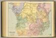
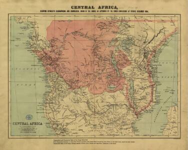
Central Africa.
1 : 5977362 Stanford, Edward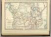
Central Africa.
1 : 10300000 Johnston, Alexander Keith
Inner Afrika. nach dem gegenwartigen stande der erforschung
1 : 17000000 Riemer, C.; Geographisches Institut. Weimar, Allemagne Weimar : Geographisches Institut
Süd-Afrika & Madagaskar
Hand-Atlas über alle Theile der Erde und über das Weltgebäude Stieler, Adolf Justus Perthes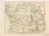
Äquatorial - Afrika

Oest. Hoch-Africa.
1 : 7500000 Weiland, C. F. (Carl Ferdinand), d. 1847
Süd-Afrika & Madagaskar
Handatlas über alle Theile der Erde und über das Weltgebäude Stieler, Adolf Justus Perthes
Riemer's Karte von Inner-Afrika
Afrika střední Riemer, C. Geographisches Institut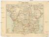
Inner-Afrika
Afrika střední Riemer, C. Geographisches Institut
Sud-Afrika & Madagaskar.
1 : 12500000 Petermann, A.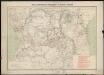
Carte des missions catholiques du centre africain
1 : 4000000 Vuillot, Paul 18..-19.. [Lyon : Oeuvre de la propagation de la foi]
Africa meridional: colonias inglesas, alemanas y portuguesas
1 : 15000000 1 mapa, col. Full d'un atles en llengua castellana no identificat, que conté mapes físics, polítics i sobre el servei de correus. Datat al 1890 aproximadament.
Mapa Afriky střední
1 : 12500000 Afrika střední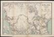
Karte von Central-Afrika. Nach den neuesten Forschungen bearbeitet von Dr. Joseph Chavanne.

Congo
1 : 15000000 1 mapa, col. Full d'un atles en llengua castellana no identificat, que conté mapes físics, polítics i sobre el servei de correus. Datat al 1890 aproximadament.
Süd-Afrika

The "Graphic" map of south-central Africa
Afrika jižní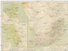
Süd-Afrika
1 : 8000000 Afrika jižní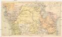
Übersichtskarte zum Zuge der Emin Pascha - Entsatzexpedition quer durch Afrika
1 : 5800000 Afrika střední F.A. Brockhaus
Nieder-Guinea und das Innere des Westlichen Mittel-Africa's oder Westrand von Hoch-Africa
1 : 5480000 entworfen und gezeichnet von C.F. Weiland gestochen von Karl Mädel sen. Weimar : Geographisches Institut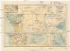
Central-Afrika mit dem internationalen Kongo-Gebiet
1 : 13000000 Afrika střední A. Hartleben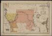
Carte politique de l'Afrique centrale
1 : 10000000 Institut national de géographie. Belgique Bruxelles : Institut national de géographie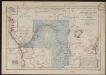
Croquis hydrographique de l'Afrique centrale
1 : 10000000 Institut national de géographie. Belgique Bruxelles : Institut national de géographie
Spezial - karte von AfricaSekt. Congo (7)
1 : 4000000 1 full d'1 mapa en 10 fulls i estoig Hermann Habenicht; Justus Perthes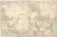
Central-Afrika
1 : 5000000 Afrika střední Chavanne, Joseph A. Hartleben's Verlag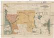
Carte politique de l'Afrique centrale
1 : 10000000 Afrika střední Institut National de géographie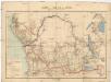
Carte du bassin du Congo
1 : 4000000 Kongo (Kinshasa) Kiepert, Richard Droysen, Wilhelm Dietrich Reimer
Stanley's Discoveries in Africa.
1 : 17500000 Colton, G.W.