Maps of Serbia

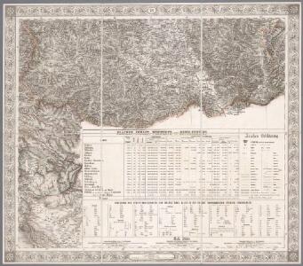
XIX, uit: General-Karte des oesterreichischen Kaiserstaates mit einem grossen Theile der angrenzenden Länder / durch Josef Scheda ... bearb. und hrsg
1 : 576000 Annotatie geografische gegevens: Maatstokken: oesterreichische Meilen, geografische oder deutsche Meilen, preussische Meilen, türkische Berri, französische Lieues, russische Werste; Maatstok per blad: wiener Klafter, öster. Meilen; Blad XIX: statistische en taalkundige informatie; Blad XIX: legenda [Wien : K.K. Militärisch-Geografisches Institut]
Sheet XIX: Karte Des Oesterreichischen Kaiserstaates.
1 : 576000 Scheda, Josef
Rascien
1 : 800000 Sandschak Novi Pazar , Kosovo
Zemljepis od Serbije
1 : 822000 Srbsko Nipočić, Vasilij u c. k. Politechničeskoj inščotugu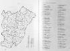
Administrative Gliederung Serbiens in Kreise und Bezirke 1902
Serbien Verwaltungsgliederung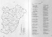
Administrative Gliederung Serbiens in Kreise und Bezirke 1890 (1891)
Serbien Verwaltungsgliederung
Hypsometrische uibersichtskarte von Bosnien der Herzegovina von Serbien und Montenegro

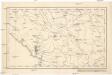
Veles, Priština, Scutari
1 : 750000 Priština (Kosovo) Konrad, A. Erben, Fr. K. u. k. Militärgeographisches Institut
Strassen- und Eisenbahnkarte des oesterreichischen Kaiserthumes
1 : 864000 Blatt 15 Schaller, G. K.K. Militärisch-Geografisches Institut, Karten-Evidenthaltungs-Abteilung
Bevölkerungsdichte 1900 (administrative Gliederung von 1902)
Serbien Bevölkerungsdichte

Übersichtskarte von Mittel - Europa

La Serbie de 1878
Serbien Geschichte
Veles, Priština, Scutari
1 : 750000 Priština (Kosovo) Erben, Fr. K. u. k. Militärgeographisches Institut
Köprülü, Priština, Scutari
1 : 750000 Priština (Kosovo) Erben, Fr. K. u. k. militär-geographisches Institut
Köprülü, Priština, Scutari
1 : 750000 Priština (Kosovo) Erben, Fr. K. u. k. militär-geographisches Institut
Köprülü, Priština, Scutari
1 : 750000 Priština (Kosovo) K. k. militär-geographisches Institut
Eisenbahnbau 1884-1915
Serbien Eisenbahnnetz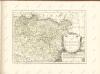
[Černá Hora, Srbsko a Makedonie]
Albánie
Nahia Pečská Diakovská i Prizrenská
Albánie Müller, Jos. D.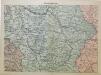
Mittel-Serbien
1 : 875000 Serbien
Karta Serbije
1 : 575000 Srbsko Bilic, F. Kocebu
Zemljepis od Serbie
1 : 830000 Srbsko Nipočić, Vasilij u c. k. Politechničeskoj inščotugu
Die Aufteilung Kosovos unter die Besatzungsmächte 1941
Kosovo Balkanfeldzug <1941>, Besetzung
Generalkarte von Zentraleuropa

Die Autonome Provinz Kosovo - Verkehrsnetz
Kosovo Verkehrsnetz
Generalkarte von Zentraleuropa
Albanie du nord
Albanien