Maps of Shkodër County

Generalkarte von Zentraleuropa

Crnagora
1 : 320000 Černá Hora Fáborský, Jan B. Dědictví Ss. Cyrila a Methoda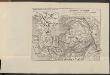
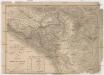
Albanie du nord
Albanien
Crnagora
Černá Hora Hofmann, A.
Eiszeitliche Vergletscherung der Gebirgsgruppen von Prokletije bis Durmitor
1 : 200000 Durmitor (Černá Hora) Cvijić, Jovan des K. u. k. Militärgeographischen Institutes
Carte de la partie d'Albanie occupé par le Bacha de Scutari. le District des Montenegrins, et partie des territoires des Rep. de Venise, et de Raguse
1 : 490000 Albánie
Carte de la partie d'Albanie occupée par le Bacha de Scutari, le district des Montenegrins, et partie des territoires des Rep. de Venise, et de Raguse
1 : 490000 Albánie
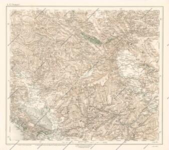
Reise durch Hochalbanien
1 : 300000 Albanien (Nord), Albanische Alpen, Reiseweg
[Nordalbanien]
Albanien
Karta od Crnegore
1 : 290000 Černá Hora Buza, Vasal L. Förster's Anstalt
Übersichtskarte von Skutari
1 : 1000000 Albanien Shkodër
Umgebung des Skutarier Sees und die Zadrimaer Niederungen
Albanien Skutarisee Péch, Béla
Novi Pazar
1 : 200000 Novi Pazar (Srbsko) Kartografska radionica
[Nordalbanien]
Albanien
Bojanamündung
Albanien Makedonien Bojana (Fluss)
Budua und Cetinje.
from Spezialkarte der osterreichisch-ungarischen Monarchie.
Situation vor Skutari in der ersten Hälfte März
1 : 100000 Albanien Shkodër Balkankrieg <1912-1913> Belagerung von Shkodër <1912-1913> Siegrist, Ed.
Stellungen der Armeen um Skutari (29. März 1913 a. St.)
Albanien Shkodër Balkankrieg <1912-1913>
Skizze des Gebiets von Spizza (Spić)
Bosnien-Herzegowina
Scutari et Environs
Albanien Shkodër Umland
Siége de Scutari par Mohammed II.
Nouvel atlas physique politique et historique de l'Empire ottoman et des états limitrophes en Europe, en Asie et en Afrique, en quarante feuilles Hellert, J.J. Bellizard, Dufour et Cie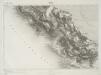
Spizza.
from Spezialkarte der osterreichisch-ungarischen Monarchie.
Situazione della Campagna e Paludi di Castel-Lastua nel Territorio di Pastrovichio
1 : 5759 Petrovac na Moru, Paštrovići Emilys
Nahia Pečská Diakovská i Prizrenská
Albánie Müller, Jos. D.
Veles, Priština, Scutari
1 : 750000 Priština (Kosovo) Erben, Fr. K. u. k. Militärgeographisches Institut
Köprülü, Priština, Scutari
1 : 750000 Priština (Kosovo) Erben, Fr. K. u. k. militär-geographisches Institut
Köprülü, Priština, Scutari
1 : 750000 Priština (Kosovo) Erben, Fr. K. u. k. militär-geographisches Institut
Köprülü, Priština, Scutari
1 : 750000 Priština (Kosovo) K. k. militär-geographisches Institut
Karta Crnegore
1 : 289000 Černá Hora Karacsay, Fedor de Allodi, P.