Maps of Bar Municipality
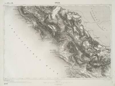
Spizza.
from Spezialkarte der osterreichisch-ungarischen Monarchie.
Skizze des Gebiets von Spizza (Spić)
Bosnien-Herzegowina
Situazione della Campagna e Paludi di Castel-Lastua nel Territorio di Pastrovichio
1 : 5759 Petrovac na Moru, Paštrovići Emilys
Bojanamündung
Albanien Makedonien Bojana (Fluss)
Scutari
1 : 200000 Shkodër (Albánie) Militärgeographisches Institut
Crnagora
Černá Hora Hofmann, A.
Adriatisches Meer, Küsten-Karte
1 : 180000 Jaderské moře (oblast) Oesterreicher, Tobias von Hydrographisches Amt der k. u. k. Kriegs-Marine
Carte de la partie d'Albanie occupé par le Bacha de Scutari. le District des Montenegrins, et partie des territoires des Rep. de Venise, et de Raguse
1 : 490000 Albánie
Carte de la partie d'Albanie occupée par le Bacha de Scutari, le district des Montenegrins, et partie des territoires des Rep. de Venise, et de Raguse
1 : 490000 Albánie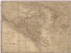
Karta Crnegore
1 : 285000 Albánie Karacsay, Fedor de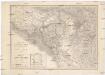
Karta Crnegore
1 : 285000 Albánie Karacsay, Fedor de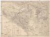
Karta Crnegore
1 : 285000 Albánie Karacsay, Fedor de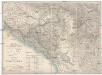
Karta Crnegore
1 : 285000 Albánie Karacsay, Fedor de
Geologische Übersichtskarte von Montenegro
1 : 450000 Černá Hora Tietze, Emil Ernst August Alfred Hölder
Map of Montenegro
Montenegro
Umgebung des Skutarier Sees und die Zadrimaer Niederungen
Albanien Skutarisee Péch, Béla
Karte von Montenegro
1 : 130000 Černá Hora
Okolí Kotoru
1 : 140000 Kotor (Černá Hora) Bedřich Sandtner
Okolí Kotoru
1 : 140000 Kotor (Černá Hora) Fáborský, Jan B. Nipočić, Vasilij Bedřich Sandtner
Der Doppelhafen von Cattaro
1 : 100000 Boka Kotorska
Karta Černogorii
1 : 317000 Černá Hora Kovalevski
Karta od Crnegore
1 : 290000 Černá Hora Buza, Vasal L. Förster's Anstalt
Bezirke von Montengro
Kroatien, Montenegro
Isole e fortesse Venezia
Albanien Venezia (bis 1797) Befestigung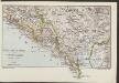
Südl. Dalmatien und Montenegro
1 : 600000 Kroatien Montenegro Dalmatien
Kreis Cattaro
1 : 144000 Kotor (Černá Hora) L.W. Seidel
Kreis Cattaro
1 : 140000 boka Kotorská (Černá Hora) Artaria
Übersichtskarte von Skutari
1 : 1000000 Albanien Shkodër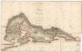
Karte der Bocche di Cattaro