Maps of Kosovo

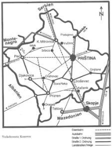
Die Autonome Provinz Kosovo - Verkehrsnetz
Kosovo Verkehrsnetz
Die Aufteilung Kosovos unter die Besatzungsmächte 1941
Kosovo Balkanfeldzug <1941>, Besetzung
Albanie du nord
Albanien
Priština
1 : 200000 Priština (Kosovo) Kartografska radionica
Karta Kosova Polja i kosovske bitke 1389
Serbien Amselfeld Schlacht auf dem Amselfeld <1389>
Skica bojnoga polja na Kosovu 1389
Kosovo, Serbien, Schlacht auf dem Amselfeld <1389>
Novi Pazar
1 : 200000 Novi Pazar (Srbsko) Kartografska radionica
[Nordalbanien]
Albanien
Zeml'ovid Kosovog polja
1 : 130600 Vasojević, Nikola Loder, I. I. Loder
Plan grada Skoplja
1 : 7500 Skopje (Makedonie) Zadužbinska štamparija Vardarske Banovine Nemanja
Veles, Priština, Scutari
1 : 750000 Priština (Kosovo) Erben, Fr. K. u. k. Militärgeographisches Institut
Köprülü, Priština, Scutari
1 : 750000 Priština (Kosovo) Erben, Fr. K. u. k. militär-geographisches Institut
Köprülü, Priština, Scutari
1 : 750000 Priština (Kosovo) Erben, Fr. K. u. k. militär-geographisches Institut
Köprülü, Priština, Scutari
1 : 750000 Priština (Kosovo) K. k. militär-geographisches Institut
Veles, Priština, Scutari
1 : 750000 Priština (Kosovo) Konrad, A. Erben, Fr. K. u. k. Militärgeographisches Institut
Rascien
1 : 800000 Sandschak Novi Pazar , Kosovo
[Černá Hora, Srbsko a Makedonie]
Albánie
Übersichtskarte von Mittel - Europa
Hypsometrische uibersichtskarte von Bosnien der Herzegovina von Serbien und Montenegro

Urbinas Handschrift
Albanien Trattato della pittura / Handschrift / Rom / Vatikanische Bibliothek / Cod. Urb. Lat.
Turquie d'Europe
Albanien Osmanisches Reich Reich
Strassen- und Eisenbahnkarte des oesterreichischen Kaiserthumes
1 : 864000 Blatt 15 Schaller, G. K.K. Militärisch-Geografisches Institut, Karten-Evidenthaltungs-Abteilung
XIX, uit: General-Karte des oesterreichischen Kaiserstaates mit einem grossen Theile der angrenzenden Länder / durch Josef Scheda ... bearb. und hrsg
1 : 576000 Annotatie geografische gegevens: Maatstokken: oesterreichische Meilen, geografische oder deutsche Meilen, preussische Meilen, türkische Berri, französische Lieues, russische Werste; Maatstok per blad: wiener Klafter, öster. Meilen; Blad XIX: statistische en taalkundige informatie; Blad XIX: legenda [Wien : K.K. Militärisch-Geografisches Institut]
Nahia Pečská Diakovská i Prizrenská
Albánie Müller, Jos. D.
Generalkarte
Albanien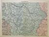
Mittel-Serbien
1 : 875000 Serbien
Mappa geographica Graecia septentrionalis hodiernae etc.
Griechenland Albanien
Atlante veneto
Albanien Venezia (bis 1797)
Ligne de partage d'après la carte annexée au traité d'alliance
Balkanhalbinsel Grenze Balkankrieg <1912-1913> Annexion