Maps of Kosovo
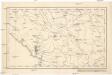
[Černá Hora, Srbsko a Makedonie]
Albánie
Veles, Priština, Scutari
1 : 750000 Priština (Kosovo) Konrad, A. Erben, Fr. K. u. k. Militärgeographisches Institut
Übersichtskarte von Mittel - Europa

Veles, Priština, Scutari
1 : 750000 Priština (Kosovo) Erben, Fr. K. u. k. Militärgeographisches Institut
Köprülü, Priština, Scutari
1 : 750000 Priština (Kosovo) Erben, Fr. K. u. k. militär-geographisches Institut
Köprülü, Priština, Scutari
1 : 750000 Priština (Kosovo) Erben, Fr. K. u. k. militär-geographisches Institut
Köprülü, Priština, Scutari
1 : 750000 Priština (Kosovo) K. k. militär-geographisches Institut
Urbinas Handschrift
Albanien Trattato della pittura / Handschrift / Rom / Vatikanische Bibliothek / Cod. Urb. Lat.
Atlas
Albanien
Rascien
1 : 800000 Sandschak Novi Pazar , Kosovo
Hungaria
Albanien Ungarn
Hypsometrische uibersichtskarte von Bosnien der Herzegovina von Serbien und Montenegro

Speculum orbis Terrarum
Albanien
Strassen- und Eisenbahnkarte des oesterreichischen Kaiserthumes
1 : 864000 Blatt 15 Schaller, G. K.K. Militärisch-Geografisches Institut, Karten-Evidenthaltungs-Abteilung
Turquie d'Europe
Albanien Osmanisches Reich Reich
Mappa geographica Graecia septentrionalis hodiernae etc.
Griechenland Albanien
Generalkarte
Albanien
XIX, uit: General-Karte des oesterreichischen Kaiserstaates mit einem grossen Theile der angrenzenden Länder / durch Josef Scheda ... bearb. und hrsg
1 : 576000 Annotatie geografische gegevens: Maatstokken: oesterreichische Meilen, geografische oder deutsche Meilen, preussische Meilen, türkische Berri, französische Lieues, russische Werste; Maatstok per blad: wiener Klafter, öster. Meilen; Blad XIX: statistische en taalkundige informatie; Blad XIX: legenda [Wien : K.K. Militärisch-Geografisches Institut]
Nord- und West-Albanien nach den Beobachtungen des k.k. Kreisphysikers Dr. J. Müller 1844
Albanien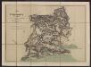
Carta di Montenegro (Crna gora)
1 : 300000 Montenegro Paulini, Giacomo
Karta Crnegore
1 : 289000 Černá Hora Karacsay, Fedor de Allodi, P.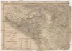
Karta Crnegore
1 : 289000 Černá Hora Karacsay, Fedor de
Crnagora
1 : 320000 Černá Hora Fáborský, Jan B. Dědictví Ss. Cyrila a Methoda
Atlante veneto
Albanien Venezia (bis 1797)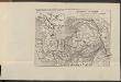
Albanie du nord
Albanien
Montenegro
1 : 600000 Montenegro
Die Aufteilung Kosovos unter die Besatzungsmächte 1941
Kosovo Balkanfeldzug <1941>, Besetzung
Die Autonome Provinz Kosovo - Verkehrsnetz
Kosovo Verkehrsnetz
Nahia Pečská Diakovská i Prizrenská
Albánie Müller, Jos. D.
![[Černá Hora, Srbsko a Makedonie]](https://images-2.georeferencer.com/images/iiif/892597812128/full/,300/0/native.jpg)

