Maps of L'viv

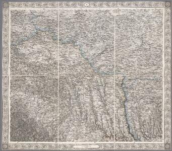
V, uit: General-Karte des oesterreichischen Kaiserstaates mit einem grossen Theile der angrenzenden Länder / durch Josef Scheda ... bearb. und hrsg
1 : 576000 Annotatie geografische gegevens: Maatstokken: oesterreichische Meilen, geografische oder deutsche Meilen, preussische Meilen, türkische Berri, französische Lieues, russische Werste; Maatstok per blad: wiener Klafter, öster. Meilen; Blad XIX: statistische en taalkundige informatie; Blad XIX: legenda [Wien : K.K. Militärisch-Geografisches Institut]
Sheet V: Karte Des Oesterreichischen Kaiserstaates.
1 : 576000 Scheda, Josef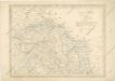
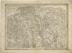
Strassen und Eisenbahnkarte des oesterreichischen Kaiserthumes

Strassen- und Eisenbahnkarte des oesterreichischen Kaiserthumes
1 : 864000 Blatt 4 Schaller, G. K.K. Militärisch-Geografisches Institut, Karten-Evidenthaltungs-Abteilung
Blatt IV, uit: Geologische Übersichts-Karte der Österreichisch-Ungarischen Monarchie / nach den Aufnahmen der K.K. Geologischen Reichsanstalt bearb. von Franz Ritter von Hauer ; gezeichn. von Eduard Jahn
1 : 576000 Annotatie geografische gegevens: Gebaseerd op veldwerk in de jaren 1850 tot 1865 Hauer, Franz Ritter von; Jahn, Eduard; Kaiserlich-Königliche Geologische Reichsanstalt, Wenen Wien : Beck
Pohlen, Rußland, Gallicien, Wolhinien, Podolien. Ungarn. Ungvárer Comitat
Ungarn Verkehrsweg
Übersichtskarte von Mittel - Europa

Übrige Länder der ehemaligen Österreich-Ung. Monarchie
1 : 900000 Halič (Polsko a Ukrajina) Koch, Wilhelm Opitz, Carl Arnd
Strategische Übersichts-Karte des polnisch-litaurischen Armee-Bewegungraumes

Tarnopol, Brody, Stryj, Czernowitz
1 : 750000 Brody (Ukrajina) Erben, F. K. u. k. Militärgeographisches Institut
Tarnopol, Brody, Stryj, Czernowitz
1 : 750000 Brody (Ukrajina) Erben, F. K. u. k. Militärgeographisches Institut
Tarnopol, Brody, Stryj, Czernowitz
1 : 750000 K. u. k. militär-geographisches Institut
Tarnopol, Brody, Stryj, Czernowitz
1 : 750000 Brody (Ukrajina) K. k. militär-geographisches Institut
Carte de la Roumanie et pays limitrophes. Lemberg
1 : 500000 France. Service géographique de l'armée [Paris] : Service géographique de l'armée
Ost Galizien
Halič (Polsko a Ukrajina) Liesganig, Joseph m Verlage des Kunst- und Industrie- Comptoirs
Galizien, Östlicher Theil und Bukowina
1 : 700000 Bukovina (Rumunsko a Ukrajina) Karl Fr. Pfau
Nr. 6b. Kämpfe in Ostgalizien. Im Dnjestrgebiet
Galizien Weltkrieg <1914-1918>, Ostfront
Strecke
Ivano-Frankivsk (Ukrajina) K. k. Österreichische Staatsbahnen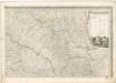
Mappa generalis regni Hungariae partiumque adnexarum Croatiae, Slavoniae...

Generalkarte von Zentraleuropa

Generalkarte von Zentraleuropa

Generalkarte von Zentraleuropa

Generalkarte von Zentraleuropa

Generalkarte von Zentraleuropa

Neue Generalkarte des Österr.-ungar.-russischen Kriegsschauplatzes

Ukrainae pars, quae Podolia palatinatus vulgo dicitur / per Guil. le Vasseur de Beauplan s. r. m.tis
1 : 420000 1 Karte : Kupferdruck ; 43 x 52 cm Beauplan, Guillaume le Vasseur de [Verlag nicht ermittelbar]
Generalkarte von Zentraleuropa
General-Karte des Königreiches Galizien und des Herzogthumes Bukovina