Maps of L'viv

Übrige Länder der ehemaligen Österreich-Ung. Monarchie
1 : 900000 Halič (Polsko a Ukrajina) Koch, Wilhelm Opitz, Carl Arnd
Pohlen, Rußland, Gallicien, Wolhinien, Podolien. Ungarn. Ungvárer Comitat
Ungarn Verkehrsweg
Strassen- und Eisenbahnkarte des oesterreichischen Kaiserthumes
1 : 864000 Blatt 4 Schaller, G. K.K. Militärisch-Geografisches Institut, Karten-Evidenthaltungs-Abteilung
Strassen und Eisenbahnkarte des oesterreichischen Kaiserthumes

Strategische Übersichts-Karte des polnisch-litaurischen Armee-Bewegungraumes

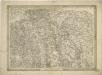
Sheet V: Karte Des Oesterreichischen Kaiserstaates.
1 : 576000 Scheda, Josef
V, uit: General-Karte des oesterreichischen Kaiserstaates mit einem grossen Theile der angrenzenden Länder / durch Josef Scheda ... bearb. und hrsg
1 : 576000 Annotatie geografische gegevens: Maatstokken: oesterreichische Meilen, geografische oder deutsche Meilen, preussische Meilen, türkische Berri, französische Lieues, russische Werste; Maatstok per blad: wiener Klafter, öster. Meilen; Blad XIX: statistische en taalkundige informatie; Blad XIX: legenda [Wien : K.K. Militärisch-Geografisches Institut]
Ost Galizien
Halič (Polsko a Ukrajina) Liesganig, Joseph m Verlage des Kunst- und Industrie- Comptoirs
Bez titulu: Šest listů speciálních map Ukrajiny

Carte de la Roumanie et pays limitrophes. Lemberg
1 : 500000 France. Service géographique de l'armée [Paris] : Service géographique de l'armée
Strecke
Ivano-Frankivsk (Ukrajina) K. k. Österreichische Staatsbahnen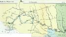
Nr. 6b. Kämpfe in Ostgalizien. Im Dnjestrgebiet
Galizien Weltkrieg <1914-1918>, Ostfront
Tarnopol, Brody, Stryj, Czernowitz
1 : 750000 Brody (Ukrajina) Erben, F. K. u. k. Militärgeographisches Institut
Tarnopol, Brody, Stryj, Czernowitz
1 : 750000 Brody (Ukrajina) Erben, F. K. u. k. Militärgeographisches Institut
Tarnopol, Brody, Stryj, Czernowitz
1 : 750000 K. u. k. militär-geographisches Institut
Tarnopol, Brody, Stryj, Czernowitz
1 : 750000 Brody (Ukrajina) K. k. militär-geographisches Institut
Neue Generalkarte des Österr.-ungar.-russischen Kriegsschauplatzes
General-Karte des Königreiches Galizien und des Herzogthumes Bukovina
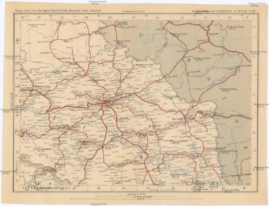
Nr. 6a. Kämpfe in Ostgalizien. Zwischen San und Bug
Galizien Weltkrieg <1914-1918>, Ostfront
General-Karte des Königreiches Galizien und des Herzogthumes Bukovina


Generalkarte von Zentraleuropa

Generalkarte von Zentraleuropa


Speciální mapa západního Ruska