Maps of Rajon Kamjanez-Podilskyj

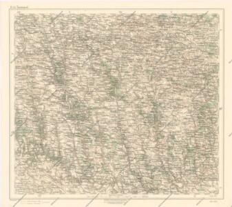
Generalkarte von Zentraleuropa

Generalkarte von Zentraleuropa

Ukrainae pars, quae Podolia palatinatus vulgo dicitur / per Guil. le Vasseur de Beauplan s. r. m.tis
1 : 420000 1 Karte : Kupferdruck ; 43 x 52 cm Beauplan, Guillaume le Vasseur de [Verlag nicht ermittelbar]


Borszczow.
from Spezialkarte der osterreichisch-ungarischen Monarchie.
Jagielnica und Czernelica.
from Spezialkarte der osterreichisch-ungarischen Monarchie.
Buczacz und Czortkow.
from Spezialkarte der osterreichisch-ungarischen Monarchie.
Skalat und Grzymakow.
from Spezialkarte der osterreichisch-ungarischen Monarchie.
Trembowla (Galizien).
from Spezialkarte der osterreichisch-ungarischen Monarchie.
Buczacz und Czortków
1 : 75000 Buchach (Ukrajina) Gehrke, A. K. u. k. Militärgeographisches Institut

Tarnopol.
from Spezialkarte der osterreichisch-ungarischen Monarchie.
Mielnica.
from Spezialkarte der osterreichisch-ungarischen Monarchie.
Kamieniec Podolski.
from Spezialkarte der osterreichisch-ungarischen Monarchie.
Zaleszczyki (Galizien).
from Spezialkarte der osterreichisch-ungarischen Monarchie.
Skałat und Grzymałów
1 : 75000 Ukrajina Steindl, F. K. u. k. Militärgeographisches Institut
Kamieniec Podolski
1 : 75000 Novakovic K. u. k. Militärgeographisches Institut
Jagielnica und Czernelica
1 : 75000 Ukrajina K. u. k. Militärgeographisches Institut
Jarmolincy und Gorodok
1 : 75000 K. u. k. Militärgeographisches Institut
Smotrycz
1 : 75000 K. u. k. Militärgeographisches Institut
Podwołoczyska
1 : 75000 Gottwald, K. K. u. k. Militärgeographisches Institut
Kopyczynce.; Spezialkarte der osterreichisch-ungarischen Monarchie.
from Spezialkarte der osterreichisch-ungarischen Monarchie. Austro-Hungarian Monarchy. Militärgeographisches Institut.,
Podwoloczyska.; Spezialkarte der osterreichisch-ungarischen Monarchie.
from Spezialkarte der osterreichisch-ungarischen Monarchie. Austro-Hungarian Monarchy. Militärgeographisches Institut.,
Bazalia
1 : 75000 K. u. k. Militärgeographisches Institut
Tarnopol
1 : 75000 Ukrajina Ginzkey, K. K. u. k. Militärgeographisches Institut
Kuźmin
1 : 75000 K. u. k. Militärgeographisches Institut
Mielnica
1 : 75000 Ukrajina Halla, R. K. u. k. Militärgeographisches Institut
Borszczów
1 : 75000 Ukrajina Kraupa, G. K. u. k. Militärgeographisches Institut