Maps of Suez
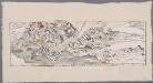
[LL.05413gk], uit: [Palestina] / [Lukas Cranach d. Ä.]
1 : 850000 Annotatie: Onderste deel van de kaart; Van deze kaart is slechts 1 ander (eveneens incompleet) exemplaar bekend (Eran Laor Map Collection, Jeruzalem), waarbij juist het onderste deel van de kaart ontbreekt; Lit.: Cartographica Helvetica, 1991, H. 3, p. 22-27; Print quarterly, vol. 12, no. 2 (1995), p. 123-144 Cranach, Lukas (de Oudere) [Wittenberg : Lukas Cranach d. Ä.]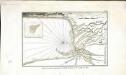
Plan de la partie septentrionale du golfe arabique et de la ville de Suès
1 Karte : Kupferdruck ; 18 x 29 cm Nyon
22 Suez.
1 : 100000 Jacotin, Pierre, 1765-1827
23 Lacs Amers.
1 : 100000 Jacotin, Pierre, 1765-1827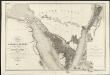
Carte de l'Arabie pétrée
1 : 500000 levée et dressée par Léon de Laborde, en 1828 rectifiée sur les observations astronomiques et les cartes de Niebuhr, Larochette, la Commission d'Egypte, Home, Popham, Valentia, Burckhardt, Erhenberg et Rüppel, et gravée par Collin, pour accompagner le voyage de l'Arabie Petrée Paris : Giard
Carte de la presqu'ile de Sinai
1 : 1000000 Sinajský poloostrov (Egypt) Service géographique de l'Armée
Geognostische Karte des peträischen Arabien und den südlichen Theiles von Sirien
1 : 880000 Sinajský poloostrov (Egypt) E. Schweizerbart'sche Buchhandlung
Aegypti Recentior Descriptio. [Karte], in: Theatrum orbis terrarum, S. 311.
1 Karte aus Atlas Ortelius, Abraham
Carte De L'Egypte et des Postes Militaires occupés et Fortifiés par les Français sous les ordres du Géneral en Chef Bounaparte, depuis leur invasion le 1. Juillet 1798, jusqu'à ce jour; Dressée d'après les relations fidelles des Chefs interceptées, et sur le compte qui en a eté rendu par les deserteurs
Kauffer, François
Suez Canal Zone (1954)
Suez Canal Zone, MDR Misc 11944. Overprinted by 42 Svy Eng Reg Nov 1954. Originally classified Restricted. Great Britain. Army. Royal Engineers. Survey Engineers Regiment, 42nd. [S.l.] : [Survey Directorate, Middle East]
Karte der Gegend zwischen Belbes und Sues
1 : 200000 Egypt Schweinfurth, Georg Geographische Verlagshandlung Dietrich Reimer
Carte générale de l'Isthme 1869
1 : 200000 Suezský průplav (Egypt) Migerkov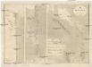
Suez Kanal
1 : 100000 Suezský průplav (Egypt) Reichs-Marine-Amt
Die südliche Galala mit dem nördlichen Theil der krystallinische Küstengebirge am Rothen Meer
1 : 200000 Schweinfurth, Georg Dietrich Reimer
Aegypti Recentio Descriptio. [Karte], in: Theatrum orbis terrarum, S. 120.
1 Karte aus Atlas Ortelius, Abraham
Land zwischen den kleinen und grossen Kataracten des Nil
1 : 288000 Egypt Prokesch, A. von Wöber, J.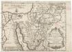
Tabula itineris, et stationum Israelitarum in deserto
1 : 950000 Palestina Starckman, P.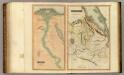
Egypt, Abyssinia.
Thomson, John
Die Nilländer...

Voyage des Israelites depuis leur sortie d'Egypte.
1 : 3000000 Houze, Antoine Philippe
Palestine, l'Arabie Petree.
1 : 1370000 Andriveau-Goujon, J.
Terre de Chanaan ou Terre Promise.
1 : 3200000 Houze, Antoine Philippe
Egypt.
1 : 1584000 Burr, David H., 1803-1875
Synoptische tafel der H. Geschiedenis : van Mozes tot aan den tempel van Salomon (1491-1005 vóór Christus) / door H. Lambrecht
Annotatie: Hierop afgebeeld: Kaart voor de geschiedenis der reis van de Joden uit Egypte naar het land van belofte en hunner intrede in dat land. - Schaal: [1:3.000.000]. Palestina tusschen de 12 stammen verdeeld. - Schaal: [1:1.875.000] [S.l. : s.n.] / (Gent : Poelman)
Polostrov [sic] Sinajský s naznačeným pochodem Israelitův přes poušť k vydobytí země Kanaan
1 : 1900000 Izrael Uměl. závod Ed. Hölzela
Mansionum populi Israelitici in deserto.
Sinajský poloostrov (Egypt) Grasmüller, E. Demeuse, Laurent
Terra Promissionis
Sinajský poloostrov (Egypt) Dalrymple, Alexander Berra, Marco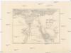
Dolní Egypt
1 : 1000000 Egypt Král z Dobré Vody, Vojtěch Fr. Šimáček
Egypt.
1 : 1950000 Greenleaf, Jeremiah
![[LL.05413gk], uit: [Palestina] / [Lukas Cranach d. Ä.]](https://images-2.georeferencer.com/images/iiif/575332125871/full/,300/0/native.jpg)

