Maps of South Sinai Governorate
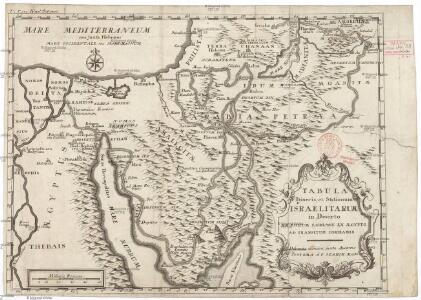
Tabula itineris, et stationum Israelitarum in deserto
1 : 950000 Palestina Starckman, P.
Mansionum populi Israelitici in deserto.
Sinajský poloostrov (Egypt) Grasmüller, E. Demeuse, Laurent
Afbeelding van Egypte, de woestyne der Schelfzee, en 't Land Kanaan : strekkende tot opheldering der bybelsche geschiedenis, dewelke begint van Jakobs vertrek naar Egypte, en eindigt met de verwinning van 't Land Kanaan
1 : 1400000 ontworpen door W.A. Bachiene J. van Jagen mapp. sculpsit, et figur. apposit. sculpturam curavit ; J.C. Philips fecit. te Gorinchem : by Nicolaas Goetzee
Terra Promissionis
Sinajský poloostrov (Egypt) Dalrymple, Alexander Berra, Marco
Egypte geog. 3.
1 : 1000000 France. Armee. Genie; Jacotin, Pierre, 1765-1827
Historische Karte von Palestinae und Arabia Petraea mit einen grossen Theil von AEgypten
1 : 1100000 Egypt Mayr, Georg Wilkendorf, Fr. Mey & Widmayer
Historický atlas revolučního hnutí

Synoptische tafel der H. Geschiedenis : van Mozes tot aan den tempel van Salomon (1491-1005 vóór Christus) / door H. Lambrecht
Annotatie: Hierop afgebeeld: Kaart voor de geschiedenis der reis van de Joden uit Egypte naar het land van belofte en hunner intrede in dat land. - Schaal: [1:3.000.000]. Palestina tusschen de 12 stammen verdeeld. - Schaal: [1:1.875.000] [S.l. : s.n.] / (Gent : Poelman)
Palestine.
1 : 1027000 Colton, G. Woolworth
Palestine, l'Arabie Petree.
1 : 1370000 Andriveau-Goujon, J.
Voyage des Israelites depuis leur sortie d'Egypte.
1 : 3000000 Houze, Antoine Philippe
Kaart van de veertigjarige omzwerving der Israëliten in de woestijn van Arabië
1 : 2550000 S.I. Mulder del. steend. v. C. W. Mieling [Leyden] : D. du Mortier & Fil. excud.
Polostrov [sic] Sinajský s naznačeným pochodem Israelitův přes poušť k vydobytí země Kanaan
1 : 1900000 Izrael Uměl. závod Ed. Hölzela
Carte de la presqu'ile de Sinai
1 : 1000000 Sinajský poloostrov (Egypt) Service géographique de l'Armée
Terre de Chanaan ou Terre Promise.
1 : 3200000 Houze, Antoine Philippe
Atlas von Palaestina und der Sinai-Halbinsel : zu C. Ritter’s Erdkunde Band XIV-XVI
1 : 333333 bearb. von Carl Zimmermann Berlin : Reimer
Geognostische Karte des peträischen Arabien und den südlichen Theiles von Sirien
1 : 880000 Sinajský poloostrov (Egypt) E. Schweizerbart'sche Buchhandlung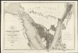
Carte de l'Arabie pétrée
1 : 500000 levée et dressée par Léon de Laborde, en 1828 rectifiée sur les observations astronomiques et les cartes de Niebuhr, Larochette, la Commission d'Egypte, Home, Popham, Valentia, Burckhardt, Erhenberg et Rüppel, et gravée par Collin, pour accompagner le voyage de l'Arabie Petrée Paris : Giard
Red Sea (1917)
[The Red Sea, in five sheets. Sheet 1. Surveyed ... 1830-4. The Gulf of Suez and Coast to Kosaïr ... 1871-2. (Sherm Joobbah.--Sherm Yahar.--Tór Harbour)]
Chorographia Terrae Sanctae in angvstiorem formam redacta, et ex variis avctoribvs a mvltis erroribvs expvrgata
1 : 400000 Izrael
Karte von Arabia Petraea

Suez Canal Zone (1954)
Suez Canal Zone, MDR Misc 11944. Overprinted by 42 Svy Eng Reg Nov 1954. Originally classified Restricted. Great Britain. Army. Royal Engineers. Survey Engineers Regiment, 42nd. [S.l.] : [Survey Directorate, Middle East]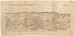
Sitvs terrae Canaan, sive Terrae promissionis, hodie Palaestinae, Ss. Bibliorvm intelligentiam exacte aperiens
Kanaán Sanson, Nicolas Adrichem, Christiaan van Pierre Mortier
Egypt.
1 : 900000 Rand McNally and Company
Palästina als Schauplatz der heiligen Geschichte
1 : 236000 Egypt Kocen, Blaž Eduard Hölzel
Palästina als Schauplatz der heiligen Geschichte
1 : 236000 Egypt Kocen, Blaž Eduard Hölzel
Palestina
1 : 236000 Egypt Kocen, Blaž Kovář, M. R. Eduard Hölzel
[Kaart], uit: [Kaart van Zuid-Israel]
1 : 250000 Annotatie: Tekst in het Hebreeuws [S.l. : s.n]
Europa.
1 : 15000000 Petermann, A.