Maps of Janub Sina'
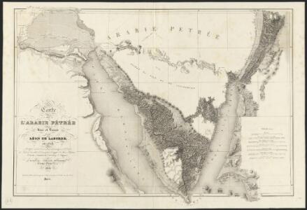
Carte de l'Arabie pétrée
1 : 500000 levée et dressée par Léon de Laborde, en 1828 rectifiée sur les observations astronomiques et les cartes de Niebuhr, Larochette, la Commission d'Egypte, Home, Popham, Valentia, Burckhardt, Erhenberg et Rüppel, et gravée par Collin, pour accompagner le voyage de l'Arabie Petrée Paris : Giard
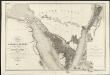
Carte de la presqu'ile de Sinai
1 : 1000000 Sinajský poloostrov (Egypt) Service géographique de l'Armée
Geognostische Karte des peträischen Arabien und den südlichen Theiles von Sirien
1 : 880000 Sinajský poloostrov (Egypt) E. Schweizerbart'sche Buchhandlung
[LL.05413gk], uit: [Palestina] / [Lukas Cranach d. Ä.]
1 : 850000 Annotatie: Onderste deel van de kaart; Van deze kaart is slechts 1 ander (eveneens incompleet) exemplaar bekend (Eran Laor Map Collection, Jeruzalem), waarbij juist het onderste deel van de kaart ontbreekt; Lit.: Cartographica Helvetica, 1991, H. 3, p. 22-27; Print quarterly, vol. 12, no. 2 (1995), p. 123-144 Cranach, Lukas (de Oudere) [Wittenberg : Lukas Cranach d. Ä.]
Karte der Gegend zwischen Belbes und Sues
1 : 200000 Egypt Schweinfurth, Georg Geographische Verlagshandlung Dietrich Reimer
Plan de la partie septentrionale du golfe arabique et de la ville de Suès
1 Karte : Kupferdruck ; 18 x 29 cm Nyon
Die südliche Galala mit dem nördlichen Theil der krystallinische Küstengebirge am Rothen Meer
1 : 200000 Schweinfurth, Georg Dietrich Reimer
Specialkarte des Kriegsschauplatzes von Ismailia bis Cairo
1 : 270000 Káhira (Egypt) Hassenstein, Bruno Justus Perthes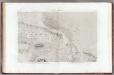
23 Lacs Amers.
1 : 100000 Jacotin, Pierre, 1765-1827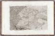
24 Le Caire, Belbeis.
1 : 100000 Jacotin, Pierre, 1765-1827
Egypt 1:100 000
1 : 100000 Sinajský poloostrov (Egypt) Survey of Egypt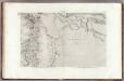
21 Memphis.
1 : 100000 Jacotin, Pierre, 1765-1827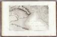
22 Suez.
1 : 100000 Jacotin, Pierre, 1765-1827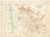
Die Umgegend von Heluan
1 : 30000 Egypt Schweinfurth, Georg Geographische Verlagshandlung Dietrich Reimer
Red Sea [Harbours and anchorages in the ] (1919)
Harbours and Anchorages in the Red Sea. (Jezirat Farausa.--Strait of Tiran). London : Admiralty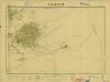
Cairo, 1:10.000 (Sheet 5)
Cairo, 1:10.000. Egypt. Maṣlaḥat al-Misāḥah. [S.l.] : Survey of Egypt
Cairo, 1:10.000 (Sheet 1)
Cairo, 1:10.000. Egypt. Maṣlaḥat al-Misāḥah. [S.l.] : Survey of Egypt
Cairo, 1:10.000 (Sheet 4)
Cairo, 1:10.000. Egypt. Maṣlaḥat al-Misāḥah. [S.l.] : Survey of Egypt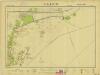
Cairo, 1:10.000 (Sheet 2)
Cairo, 1:10.000. Egypt. Maṣlaḥat al-Misāḥah. [S.l.] : Survey of Egypt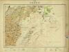
Cairo, 1:10.000 (Sheet 7)
Cairo, 1:10.000. Egypt. Maṣlaḥat al-Misāḥah. [S.l.] : Survey of Egypt
Ismailia [Town plan of] (1955)
Town plan of Ismailia, MDR Misc 11831. Great Britain. Army. Royal Engineers. Survey Engineers Regiment, 42nd. [S.l.] : [Survey Directorate, Middle East]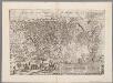
[Recto], uit: Cairos, quae olim Babylon; Aegypti maxima urbs / [Georg Braun & Franz Hogenberg]
1 : 18000 Annotatie: Afkomstig uit een van de tussen 1572 en 1624 verschenen edities van "Civitatis orbis terrarum Braun, Georg (1541-1622); Hogenberg, Franz [Colonia Agrippina : Braun & Hogenberg]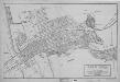
Ismailia [Plan of] (1951)
Plan of Ismailia, MDR Misc 11281. Great Britain. Army. Royal Engineers. Survey Engineers Regiment, 42nd. [Cairo] : [Survey Directorate, Middle East]
Cairo [Bounds maps of ] (1946)
Bounds map of Cairo, MDR Misc 9528. Shows areas and roads in Cairo out of bounds to British troops♯ Overprinted on a town plan published by Survey of Egypt in 1943. 653.00:0/0 . Great Britain. Army. Royal Engineers. Field Survey Company, 512th. [Cairo] : [Survey Directorate, Middle East]
Plan de la propriété des héritiers de son altesse feu prince Halim Pacha à l'Ezbekieh-Caïre : ancien état du lieu avant 1875
1 : 500 Annotatie: Tekst ook in het Arabisch [S.l. : s.n.]
Plan de la propriété des héritiers de son altesse feu prince Halim Pacha à l'Ezbekieh-Caïre : état actuel
1 : 500 Annotatie: Tekst ook in het Arabisch [S.l. : s.n.]
[Kaart], uit: New map of Cairo and environs / by Alexander Nicohosoff
1 : 15000 Nicohosoff, Alexander Alexandria : "Art Graphique"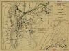
Cairo [Civil security scheme] (1942)
Civil security scheme, Cairo, MDR Misc 875. Overprinted on Outline map of Cairo, published by Survey of Egypt. Overprint shows Roads maintained open for military traffic" and "Potential centres of disturbance". Originally classified Secret." Great Britain. Army. Royal Engineers. Field Survey Company, 512th. [Cairo] : [Survey Directorate, Middle East]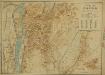
Cairo [General map of] (1924)
General map of Cairo. Great Britain. Ordnance Survey. [S.l.] : Ordnance Survey