Maps of Greece

Feuille 39 (D VI), uit: Carte géologique internationale de l'Europe : la carte, votée au congrès géologique international de Bologne en 1881, est exécutée conformément aux décisions d'une commission internationale, avec le concours des gouvernements, sous le dir. de M.M. Beyrich et Hauchecorne
Annotatie: Blad 48 gamme des couleurs; blad 49: bladwijzer en titelblad Heinrich Ernst Beyrich 1815-1896; Wi. Hauchecorne Berlin : Reimer / (Berlin: Institut lithographique)
Řecko, Albanie a jižní Italie [sic]
1 : 2500000 Albánie V. Neubert a synové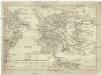
Das alte Griechenland mit dessen vmliegenden Insvlen
Řecko
Řecko a jeho kolonie r. 500 př. Kr
Řecko
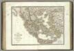
Graecia vetus
1 : 7900000 Řecko Bonne, Rigobert André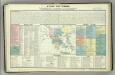
Tableau historique de la Grece.
1 : 5500000 Duval, Henri
Tabula Europae X. [Karte], in: Geographia universalis vetus et nova complectens Claudii Ptolemaei Alexandrini enarrationis libros VIII, S. 251.
1 Karte aus Atlas Münster, Sebastian [und Ptolemaeus, Claudius]
Graeciae Universae Secundum Hodiernum Situm Neoterica Descriptio. [Karte], in: Theatrum orbis terrarum, S. 347.
1 Karte aus Atlas Ortelius, Abraham Vrients, Jan Baptista
Graeciae Universae Secundum Hodiernum Situm Neoterica Descriptio. [Karte], in: Theatrum orbis terrarum, S. 95.
1 Karte aus Atlas Ortelius, Abraham
Graeciae Universae Secundum Hodiernum Situm Neoterica Descriptio. [Karte], in: Theatrum orbis terrarum, S. 252.
1 Karte aus Atlas Ortelius, Abraham
Übersichtskarte von Griechenland
Originaltitel: Carte Griechenlands nach den neuesten und besten Quellen bearbeitet. Mit Erklärung der Zeichen sowie einer Nebenkarte. Fischer, J., Lithograf
Carte de la Turque d'Europe et de la Grece.
1 : 3450000 Vivien de St Martin, L.
Graecia. [Karte], in: Le théâtre du monde, ou, Nouvel atlas contenant les chartes et descriptions de tous les païs de la terre, Bd. 3, S. 290.
1 Karte aus Atlas Blaeu, Willem Janszoon und Blaeu, Joan Blaeu, Willem Janszoon
Decima Europe Tabula [Karte], in: [Clavdii Ptholomei Cosmographi ...], S. 284.
1 Karte aus Atlas Nicolaus Germanus [und Ptolemaeus, Claudius]
Graecia. [Karte], in: Novus Atlas, das ist, Weltbeschreibung, Bd. 3, S. 332.
1 Karte aus Atlas Blaeu, Joan Blaeu, Willem Janszoon
Graecia. [Karte], in: Theatrum orbis terrarum, sive, Atlas novus, Bd. 3, S. 282.
1 Karte aus Atlas Blaeu, Joan Blaeu, Willem Janszoon
Graecia [Karte], in: Gerardi Mercatoris Atlas, sive, Cosmographicae meditationes de fabrica mundi et fabricati figura, S. 484.
1 Karte aus Atlas Mercator, Gerhard Montanus, Petrus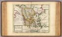
Greece or the south part of Turky in Europe.
1 : 4700000 Moll, Herman, d. 1732
Graecia [Karte], in: Gerardi Mercatoris et I. Hondii Newer Atlas, oder, Grosses Weltbuch, Bd. 2, S. 327.
1 Karte aus Atlas Mercator, Gerhard und Hondius, Jodocus Jansson, Jan
[Řecko]
1 : 1900000 Řecko
Das Alte Griechenland
Historisch-genealogisch-geographischer Atlas von Le Sage Las Cases, Emmanuel Auguste Dieudonné Marius Joseph de Johann Velten, Kunsthändler
Nova Totius Graeciae descriptio. [Karte], in: Novus atlas absolutissimus, Bd. 5, S. 274.
1 Karte aus Atlas Janssonius Offizin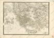
Bez titulu: Historický Atlas

GRÆCIA
Joh. et Corn. Blaeu exc.
Graecia
1 : 2500000 Annotatie: Met opdracht door Joh. en Cornelius Blaeu aan Claudius Salmasius; Origineel is Blad 169 in atlas factice; Annotatie geografische gegevens: Met schaalstok Joan Blaeu 1597/98-1673; Cornelis Blaeu ca. 1610-1645 [Amsterdam : Joh. et Corn. Blaeu excudit]
GRAECIAE et ARCHIPELAGI delineatio
Řecko
Grece.
1 : 2000000 Vivien St Martin, L.
Grece Ancienne.
1 : 2640000 Monin, C.V.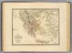
Grece ancienne.
1 : 2000000 Andriveau-Goujon, J.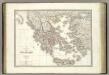
Grece ancienne.
1 : 1900000 Lapie, M. (Pierre), 1779-1850