Maps of Polynesia
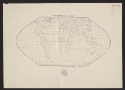
Umriszhandkarte der Erde in Eckerts flächentreuer Projektion
1 : 90000000 Wagner, H. Verlag von H. Wagner u. E. Debes
Algemeene wereldkaart
1 : 75000000 C. van Baarsel en zoon del. et sculps. uitg. door de Maatschappij tot Nut van het Algemeen Te Leijden [etc.] : Du Mortier [etc.]
Östlicher Planiglob
Neuer Handatlas über alle Theile der Erde Kiepert, Heinrich Verlag von Dietrich Reimer
General chart.
1 : 45000000 Roberts, Henry, Lieut.
Orbis Terrae Compendiosa Descriptio [Karte], in: Gerardi Mercatoris Atlas, sive, Cosmographicae meditationes de fabrica mundi et fabricati figura, S. 58.
1 Karte aus Atlas Mercator, Gerhard Montanus, Petrus
General chart Cook voyages.
1 : 45000000 Roberts, Henry, Lieut.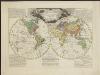
Wijsgeerige en staatkundige waereldkaart, waar op de reizen van Cook en La Perouse geteekend zijn
1 : 65000000 door L. Brion den vader aardrijks en krijgsbouwkundigen C. van Baarsel sculp. ; naar het Fransch Te Amsterdam : bij J. Allart
Orbis Terrae Compendiosa Descriptio [Karte], in: Atlas, sive, Cosmographicae meditationes de fabrica mundi et fabricati figura, S. 62.
1 Karte aus Atlas Mercator, Gerhard
[Neuer Atlas der ganzen Erde nach den neuesten Bestimmungen ... : I.] Oestliche und Westliche Halbkugel der Erde
Neu entworfen und gezeichnet von M. Riedig H. Leutemann sc. Leipzig : J.C. Hinrichs'sche Buch- und Landkartenhandlung
Karte für die in den Jahren 1827-1831 Beobachteten Werthe der Declination
Erster Band, enthaltend in vier Abtheilungen die Erscheinungen der anorganischen Natur: 1. Meteorologie und Klimatographie. 2. Hydrologie und Hydrographie. 3. Geologie. 4. Tellurischer Magnetismus Humboldt, Alexander von Verlag von Justus Perthes
Oestlicher Planiglob der Erde
1 : 17000000 Weimar : Verlag des Geographischen Instituts
Kaart der ontdekkingen gedaan door kapitein James Cook op zijne drie reistogten, met aanwijzing der koers van de schepen welke onder zijn bevel stonden
1 : 80000000 Van Baersel en Tuyn del. lithografie van R. de Vries Jr. ; naar het ontwerp van den Engelschen Luitenant ter Zee, H. Roberts [S.l.] : [s.n.]
The Phenomena of Volcanic Action Showing the Regions visited by Earthquakes and the Distitbution of Volcanoes over the Globe
The physical atlas Johnston, Alexander Keith William Blackwood & Sons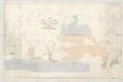
A chart showing the favorite resort of the sperm and right whale
1 : 40000000 Maury, Matthew Fontaine Lith. of Endicott & Co.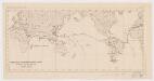
Viaggio della R[a] Corvetta 'Vettor Pisani'
1 : 250500 Bruno e Salomone Stab. Lit. Bruno e Salomone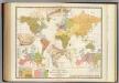
Religious belief.
1 : 66000000 Johnston, Alexander Keith, 1804-1871
Typus Orbis A Ptol. Descriptus [Karte], in: Geographia universalis vetus et nova complectens Claudii Ptolemaei Alexandrini enarrationis libros VIII, S. 219.
1 Karte aus Atlas Münster, Sebastian [und Ptolemaeus, Claudius]
The World
A new general atlas of modern geography, consisting of a complete collection of maps of the four quarters of the globe Wyld, James James Wyld
VI. Charte für die allgemeine Geschichte von Carl dem Grossen bis auf Papst Gregor VII. : d.i. von 768 bis 1073 nach Christus
Entworfen von F.W. Benicken gez. von C.F. Weiland ; in Stein gravirt v. A. Falger Weimar : im Verlage des L. Industrie-Comptoirs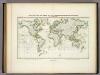
Beobachteten Werthe Der Declination.
1 : 130000000 Berghaus, Heinrich
Currents, whaling grounds.
1 : 140000000 United States Exploring Expedition (1838-1842); Wilkes, Charles, 1798-1877
World, Mercator's projection.
1 : 82000000 Hall, S. (Sidney)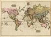
The World on Mercator's projection.
1 : 40000000 Pinkerton, John, 1758-1826
America sive India Nova. [Karte] [Golfo Mexicano] [Nebenkarte] [Cuba] [Nebenkarte] [Haiti nun Hispaniola] [Nebenkarte], in: Gerardi Mercatoris Atlas, sive, Cosmographicae meditationes de fabrica mundi et fabricati figura, S. 73.
1 Karte aus Atlas Mercator, Gerhard Montanus, Petrus
Isothermal, winds; Religions Europe.
Andree, Richard; Times (London, England)
Isothermen- u. Windkarte; Religionskarte v. Europa.
Andree, Richard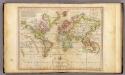
The World on Mercator's Projection.
1 : 135000000 Melish, John
Planiglob zur Ubersicht der Verbreitung der Deutschen
1 : 140000000 Berghaus, Heinrich
Wachsende Karte Der Magnetischen Meridiane Und Parallelen.
1 : 130000000 Berghaus, Heinrich