Maps of Polynesia

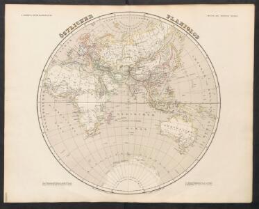
Östlicher Planiglob
Neuer Handatlas über alle Theile der Erde Kiepert, Heinrich Verlag von Dietrich Reimer
Orbis Terrae Compendiosa Descriptio [Karte], in: Atlas, sive, Cosmographicae meditationes de fabrica mundi et fabricati figura, S. 62.
1 Karte aus Atlas Mercator, Gerhard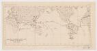
Viaggio della R[a] Corvetta 'Vettor Pisani'
1 : 250500 Bruno e Salomone Stab. Lit. Bruno e Salomone
Orbis Terrae Compendiosa Descriptio [Karte], in: Gerardi Mercatoris Atlas, sive, Cosmographicae meditationes de fabrica mundi et fabricati figura, S. 58.
1 Karte aus Atlas Mercator, Gerhard Montanus, Petrus
Algemeene wereldkaart
1 : 75000000 C. van Baarsel en zoon del. et sculps. uitg. door de Maatschappij tot Nut van het Algemeen Te Leijden [etc.] : Du Mortier [etc.]
Wijsgeerige en staatkundige waereldkaart, waar op de reizen van Cook en La Perouse geteekend zijn
1 : 65000000 door L. Brion den vader aardrijks en krijgsbouwkundigen C. van Baarsel sculp. ; naar het Fransch Te Amsterdam : bij J. Allart
Karte für die in den Jahren 1827-1831 Beobachteten Werthe der Declination
Erster Band, enthaltend in vier Abtheilungen die Erscheinungen der anorganischen Natur: 1. Meteorologie und Klimatographie. 2. Hydrologie und Hydrographie. 3. Geologie. 4. Tellurischer Magnetismus Humboldt, Alexander von Verlag von Justus Perthes
Religious belief.
1 : 66000000 Johnston, Alexander Keith, 1804-1871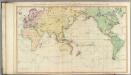
General chart.
1 : 45000000 Roberts, Henry, Lieut.
The Phenomena of Volcanic Action Showing the Regions visited by Earthquakes and the Distitbution of Volcanoes over the Globe
The physical atlas Johnston, Alexander Keith William Blackwood & Sons
The World
A new general atlas of modern geography, consisting of a complete collection of maps of the four quarters of the globe Wyld, James James Wyld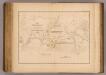
Currents, whaling grounds.
1 : 140000000 United States Exploring Expedition (1838-1842); Wilkes, Charles, 1798-1877
Planiglob zur Ubersicht der Verbreitung der Deutschen
1 : 140000000 Berghaus, Heinrich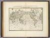
Wachsende Karte Der Magnetischen Meridiane Und Parallelen.
1 : 130000000 Berghaus, Heinrich
[Neuer Atlas der ganzen Erde nach den neuesten Bestimmungen ... : I.] Oestliche und Westliche Halbkugel der Erde
Neu entworfen und gezeichnet von M. Riedig H. Leutemann sc. Leipzig : J.C. Hinrichs'sche Buch- und Landkartenhandlung
America sive India Nova. [Karte] [Golfo Mexicano] [Nebenkarte] [Cuba] [Nebenkarte] [Haiti nun Hispaniola] [Nebenkarte], in: Gerardi Mercatoris Atlas, sive, Cosmographicae meditationes de fabrica mundi et fabricati figura, S. 73.
1 Karte aus Atlas Mercator, Gerhard Montanus, Petrus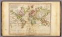
The World on Mercator's Projection.
1 : 135000000 Melish, John
World On Mercator's Projection.
1 : 150000000 Finley, Anthony
Plain map (World)
1 : 100000000 Wauthier, J. M.
Planiglob zur Übersicht der Geographischen Verbreitung der vornehmsten Krankheiten, denen der Mensch auf der ganzen Erde ausgesetzt ist
Zweiter Band, enthaltend in vier Abtheilungen die Vertheilung der Organismen: 5. Pflanzen-Geographie, 6. Thier-Geographie, 7. Anthropographie, 8. Ethnographie Humboldt, Alexander von Verlag von Justus Perthes
Oestlicher Planiglob der Erde
1 : 17000000 Weimar : Verlag des Geographischen Instituts
Mean Annual Temperature of the Earth's Surface.
1 : 110000000 Hughes, William
Übersichts-Karte für die wichtigsten Culturpflanzen der Erde, mit Angabe ihres Vaterlandes und ihrer geographischen Verbreitung
Atlas der Pflanzengeographie über alle Theile der Erde Rudolphi, Ludwig Verlag der Nicolaischen Buchhandlung
Planiglob Zur Ubersicht der Geographischen Verbreitung Der Vornehmsten Krankheiten.
1 : 140000000 Berghaus, Heinrich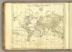
World.
1 : 94000000 Jefferys, Thomas
World (blank)
1 : 94000000 Jefferys, Thomas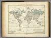
Alexander von Humboldt's System Der Isotherm-Kurven.
1 : 110000000 Humboldt, Alexander von, 1769-1859
Geographische Verbreitung und Vertheilung der Raubthiere, Carnivora.
1 : 115000000 Berghaus, Heinrich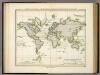
Ubersicht Der Mittleren Barometerstande Am Meere Und Der Oscillationen.
1 : 110000000 Berghaus, Heinrich