Maps of Polynesia
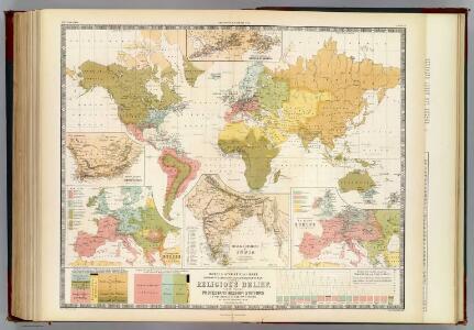
Religious belief.
1 : 66000000 Johnston, Alexander Keith, 1804-1871
Planiglob zur Ubersicht der Verbreitung der Deutschen
1 : 140000000 Berghaus, Heinrich
Wachsende Karte Der Magnetischen Meridiane Und Parallelen.
1 : 130000000 Berghaus, Heinrich
World On Mercator's Projection.
1 : 150000000 Finley, Anthony
Plain map (World)
1 : 100000000 Wauthier, J. M.
Mean Annual Temperature of the Earth's Surface.
1 : 110000000 Hughes, William
Planiglob Zur Ubersicht der Geographischen Verbreitung Der Vornehmsten Krankheiten.
1 : 140000000 Berghaus, Heinrich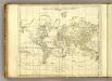
World.
1 : 94000000 Jefferys, Thomas
World (blank)
1 : 94000000 Jefferys, Thomas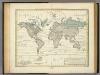
Alexander von Humboldt's System Der Isotherm-Kurven.
1 : 110000000 Humboldt, Alexander von, 1769-1859
Geographische Verbreitung und Vertheilung der Raubthiere, Carnivora.
1 : 115000000 Berghaus, Heinrich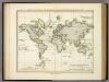
Ubersicht Der Mittleren Barometerstande Am Meere Und Der Oscillationen.
1 : 110000000 Berghaus, Heinrich
Vegetationsgebiete, Thiere.
1 : 180000000 Andree, Richard
Volkerkarte, Religionskarte.
1 : 180000000 Andree, Richard
The world.
1 : 105000000 Lloyd, H.H.
The world.
1 : 105000000 Walling, H. F.
Map of The World Showing ... The Animal Kingdom ... Commerce And Navigation.
1 : 200000000 Johnson, A.J.
Map of The World Illustrating ... Meteorology ... Rain ... Plants.
1 : 200000000 Johnson, A.J.
Map of The World Illustrating ... The Land ... Co-Tidal Lines ... Ocean Currents.
1 : 200000000 Johnson, A.J.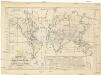
Vertheilung der Regen, Winde, Wärme und magnetischen Ströme im Monate Juli
země světa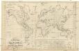
Vertheilung der Regen, Winde, Wärme und magnetischen Ströme im Monate Januar
země světa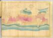
Chart Of The World Shewing The Tracks of the U.S. Exploring Expedition.
1 : 100000000 Wilkes, Charles, 1798-1877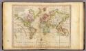
The World on Mercator's Projection.
1 : 135000000 Melish, John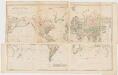
Chart of the world on Mercators projection : exhibiting all the new discoveries to the present time, with the tracks of the most distinguished navigators since the year 1700 carefully collected from the best charts, maps, voyages, &c. extant and regulated from the accurate astronomical observations made in three voyages performed under the command of Captn. James Cook in the years 1768, 69, 70, 71, 72, 73, 74, 75, 76, 77, 78, 79 & 80
1 : 20000000 Arrowsmith, Aaron, 1750-1823 A. Arrowsmith
Geographische Verbreitung und Vertheilung der Raubthiere, Carnivora
Zweiter Band, enthaltend in vier Abtheilungen die Vertheilung der Organismen: 5. Pflanzen-Geographie, 6. Thier-Geographie, 7. Anthropographie, 8. Ethnographie Humboldt, Alexander von Verlag von Justus Perthes
Typus Orbis A Ptol. Descriptus [Karte], in: Geographia universalis vetus et nova complectens Claudii Ptolemaei Alexandrini enarrationis libros VIII, S. 219.
1 Karte aus Atlas Münster, Sebastian [und Ptolemaeus, Claudius]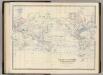
World Mercators proj.
1 : 70000000 Johnston, Alexander Keith, 1804-1871
World.
1 : 45000000 Robert Laurie & James Whittle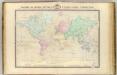
Le Monde, principales decouvertes.
1 : 60000000 Garnier, F. A., 1803-1863