Maps of Balkan Pen.

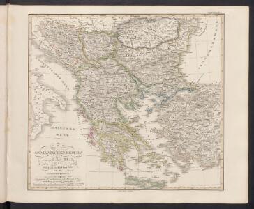
Des Osmanischen Reichs europäischer Theil, Griechenland und die Jonischen Inseln
Hand-Atlas über alle Theile der Erde nach dem neuesten Zustande und über das Weltgebäude Stieler, Adolf bei Justus Perthes
Des Osmanischen Reichs europäischer Theil, Griechenland und die Jonischen Inseln
Hand-Atlas über alle Theile der Erde nach dem neuesten Zustande und über das Weltgebäude Stieler, Adolf bei Justus Perthes

[Ethnographische Karte des Osmanischen Reichs europäischen Theils und von Griechenland]
Zweiter Band, enthaltend in vier Abtheilungen die Vertheilung der Organismen: 5. Pflanzen-Geographie, 6. Thier-Geographie, 7. Anthropographie, 8. Ethnographie Humboldt, Alexander von Verlag von Justus Perthes
Des Osmanischen Reichs europäischer Theil, Griechenland und die Jonischen Inseln
osmanská říše Stülpnagel, Friedrich von Jättnig, Karl Justus Perthes
Bodenschätze und Industrie
Balkanhalbinsel Wirtschaft, Mineralischer Rohstoff
Balkan-Halbinsel
Adolf Stieler's Handatlas über alle Theile der Erde und über das Weltgebäude Stieler, Adolf Justus Perthes
Ethnographische Karte des Osmanischen Reichs.
1 : 3800000 Berghaus, Heinrich
Völkerkarte
Südosteuropa Ethnische Gruppe

The First Bulgarian Empire
Bulgarien Simeon I., Bulgarien, Zar, Samuil, Bulgarien, Zar
Die Europaeische Türkei, Griechenland und die Ionischen Inseln
1 : 6000000 Balkanhalbinsel
Balkanländer von 1878-1915
1 : 15000000 Balkanhalbinsel
Servia under Dušan c. 1350
Serbien Stefan Dušan, Srbija, Car
Europäische Türkei von 1812-1878 (Berliner Kongreß)
1 : 15000000 Osmanisches Reich / Europäischer Teil Berliner Kongress
Der europäische Theil des Türkischen Reichs
1 : 1680000 Evropa jihovýchodní Reichard, C. G. Campe, Friedrich Friedrich Campe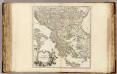
Turquie Europeenne.
1 : 2800000 Robert de Vaugondy, Gilles, 1688-1766
Siebenbürgen die Türkey und Griechenland
1 : 4930000 Sedmihradsko (Rumunsko) Grimm, I. L. Siebert, Selmar Simon Schropp
Siebenbürgen die Türkey und Griechenland
Sedmihradsko (Rumunsko) Grimm, I. L. Siebert, Selmar Simon Schropp
H. Kiepert's Generalkarte der südost-europäischen Halbinsel
1 : 1500000 Balkánský poloostrov Bischoff, C. Kiepert, Heinrich Dietrich Reimer
Das osmanische Europa oder die europaeische Türkey
1 : 3000000 Evropa jihovýchodní Weiland, Karl Ferdinand Jungmann, Carl Geograph. Institut
Země jihoslovanské
balkánské země Fáborský, Jan B. Nipočić, Vasilij
Ethnographische Übersicht des europäischen Orients
Bospor (Turecko : průliv) Kiepert, Heinrich D. Reimer
[Karte der Balkan-Halbinsel]
Balkánský poloostrov
Die Staaten der Balkan-Halbinsel
1 : 3000000 Evropa jihovýchodní Kiepert, Heinrich Dietrich Reimer
Osmanischen Reichs europ. Theil, Griechenland.
1 : 10200000 Brudin, J. L.; Stieler, Adolf
Hungary, European Turkey.
1 : 3100000 Playfair, Principal
Granicitě na Ochridskata Archieposkopija [2]
Makedonien Ohrid Patriarchat Ohrid Grenze
Karte von der europäischen Türkey
1 : 4200000 Evropa jihovýchodní Mollo, Tranquillo T. Mollo