Maps of Balkan Pen.

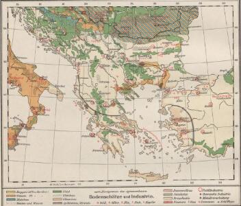
Bodenschätze und Industrie
Balkanhalbinsel Wirtschaft, Mineralischer Rohstoff
Völkerkarte
Südosteuropa Ethnische Gruppe
Balkan-Halbinsel
Adolf Stieler's Handatlas über alle Theile der Erde und über das Weltgebäude Stieler, Adolf Justus Perthes
Die Europaeische Türkei, Griechenland und die Ionischen Inseln
1 : 6000000 Balkanhalbinsel
Der europäische Theil des Türkischen Reichs
1 : 1680000 Evropa jihovýchodní Reichard, C. G. Campe, Friedrich Friedrich Campe
Des Osmanischen Reichs europäischer Theil, Griechenland und die Jonischen Inseln
Hand-Atlas über alle Theile der Erde nach dem neuesten Zustande und über das Weltgebäude Stieler, Adolf bei Justus Perthes
Des Osmanischen Reichs europäischer Theil, Griechenland und die Jonischen Inseln
Hand-Atlas über alle Theile der Erde nach dem neuesten Zustande und über das Weltgebäude Stieler, Adolf bei Justus Perthes

H. Kiepert's Generalkarte der südost-europäischen Halbinsel
1 : 1500000 Balkánský poloostrov Bischoff, C. Kiepert, Heinrich Dietrich Reimer
Balkan-Halbinsel
1 : 4500000 Balkanhalbinsel
[Ethnographische Karte des Osmanischen Reichs europäischen Theils und von Griechenland]
Zweiter Band, enthaltend in vier Abtheilungen die Vertheilung der Organismen: 5. Pflanzen-Geographie, 6. Thier-Geographie, 7. Anthropographie, 8. Ethnographie Humboldt, Alexander von Verlag von Justus Perthes
The First Bulgarian Empire
Bulgarien Simeon I., Bulgarien, Zar, Samuil, Bulgarien, Zar
Das osmanische Europa oder die europaeische Türkey
1 : 3000000 Evropa jihovýchodní Weiland, Karl Ferdinand Jungmann, Carl Geograph. Institut
Turquie Europeenne.
1 : 2800000 Robert de Vaugondy, Gilles, 1688-1766
Des Osmanischen Reichs europäischer Theil, Griechenland und die Jonischen Inseln
osmanská říše Stülpnagel, Friedrich von Jättnig, Karl Justus Perthes
Balkan Halbinsel.Stumme Physikalische Schul-Wandkarten der Länder Europas
mapa VKOL Kiepert, Richard Verlag von Dietrich Reimer
Balkan-Halbinsel.Politische Schul-Wandkarten der Länder Europa's
mapa VKOL Kiepert, Richard Verlag von Dietrich Reimer
Servia under Dušan c. 1350
Serbien Stefan Dušan, Srbija, Car
Ethnographische Karte des Osmanischen Reichs.
1 : 3800000 Berghaus, Heinrich
Charte vom Türkischen Reiche in Europa
1 : 3400000 Balkánský poloostrov Reinecke, Johann Christoph Matthias im Verlage des Geogr. Instituts
Das Osmanische Reich in Europa
1 : 925000 Evropa jihovýchodní Danielow, Iwan Mollo, Tranquillo Tranquillo Mollo
Verkehrspolitische Karte der Balkanstaaten
1 : 2500000 balkánské země
Der Europäische Theil des Türkischen Reichs
1 : 2020000 Balkánský poloostrov Reichard, C. G. Campe, Friedrich bei Friedrich Campe
Charte vom Türkischen Reiche in Europa / nach den neuesten astronomischen Ortsbestimmungen entworfe
1 : 3500000 1 Karte : Kupferdruck ; 46 x 45 cm Reinecke, Johann Matthias Christoph Verlag des Geogr. Instituts
Hungary, European Turkey.
1 : 3100000 Playfair, Principal

Charte vom Türkischen Reiche in Europa
1 : 3400000 Balkánský poloostrov Reinecke, Johann Christoph Matthias im Verlage des Industrie Comptoirs
Types et variétés psychiques des Yougoslaves
1 : 3000000 Balkanhalbinsel Südosteuropa Ethnische Gruppe L. Wuhrer Lith.
Carte de la Péninsule des Balkans
1 : 3000000 Balkanhalbinsel Südosteuropa L. Wuhrer Lith.