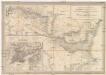
Maps of Balkan Pen.

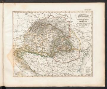
Galizien, Ungarn mit Slavonien und Croatien, Siebenbürgen und Dalmatien, Moldau, Wallachey
Hand-Atlas über alle Theile der Erde nach dem neuesten Zustande und über das Weltgebäude Stieler, Adolf bei Justus Perthes
Le Royaume De Hongrie, et les Estats qui en ont esté sujets, et qui sont preventement La Partie Septentrionale De La Tourquie En Europe [Karte], in: Atlas nouveau, contenant toutes les parties du monde [...], Bd. 2, S. 197.
1 Karte aus Atlas Sanson, Nicolas Jaillot, Alexis Hubert und Mortier, Pieter
Der Balkan
1 : 2000000 Velhagen & Klasing. Firm Bielefeld : Velhagen & Klafing
A sea chart of the Gulph of VENICE describing all the sea coasts and Islands contained therein
from The sea-atlas : containing an hydrographical description of most of the sea-coasts of the known parts of the world.
Österreichisch-Ungarische Monarchie
Handatlas über alle Theile der Erde und über das Weltgebäude Stieler, Adolf Justus Perthes
Südosteuropa mit den von 1919 bis 1938 geltenden Staatsgrenzen
Südosteuropa Grenzen
Artaria's Eisenbahnkarte
1 : 1500000 Evropa jihovýchodní Peucker, Karl Artaria
Die Donaustaaten

Die Länder des Grössten Völkergemisches
1 : 20000000 Ostmitteleuropa, Südosteuropa
Pannonien zur Zeit des Svatopluk 895
1 : 15000000 Pannonien Swatopluk I., Mähren, Herzog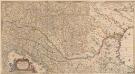
Totius Regni Hungariae, Maximaeque Partis Danubii Fluminis, una cum adjacentibus et finitimis Regionibus Novissima Delineatio [Karte], in: Novus atlas absolutissimus, Bd. 2, S. 293.
1 Karte aus Atlas Janssonius Offizin
Die Donaustaaten
1 : 2500000 Dunaj-oblast Steinhauser, Anton Peucker, Karl Artaria
Marche des Ostrogoths à travers l’Europe méridionale
Mitteleuropa Ostgoten Völkerwanderungszeit Völkerwanderung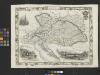
Austria
From Austria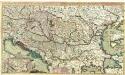
Theatre de la Guerre en Hongrie, Bosnie, Servie, et Tartarie Crimee, en il Grandes Feuilles
1 : 2000000 Mollova mapová sbírka Briffaut, Etienne Briffaut, Etienne
Daciarum, Moesiarumque, Vetus Descriptio. [Karte], in: Theatrum orbis terrarum, S. 505.
1 Karte aus Atlas Ortelius, Abraham Vrients, Jan Baptista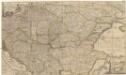
Accurate Landkarte die Königreiche Ober- und Nieder- Hungarn, Slavonien, Croatien, Dalmatien, Bosnien, Servien, Bulgarien, und Romanien, das Groß Fürstenthum Siebenbürgen, die Fürstenthümer Moldau, Wallachen, Bessarabien, die Oczakowisch- und Crimische Tartaren, die pohlnische Provinz Podolien, wie auch ein Theil von Ukranien, und übrige angränzende Ländern vorstellend
1 : 1430000 Besarábie (Moldavsko a Ukrajina) Lidl, Johann Jakob Joh. Jacob Lidl
Polonia Et Ungaria, XV. Nova Tabula. [Karte], in: Geographia universalis vetus et nova complectens Claudii Ptolemaei Alexandrini enarrationis libros VIII, S. 338.
1 Karte aus Atlas Münster, Sebastian [und Ptolemaeus, Claudius]
Die Donauländer
1 : 5000000 Österreich-Ungarn, Balkanhalbinsel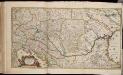
Totius Regni Hungariae maximaeque partis Danubii fluminis, una cum adjacentibus et finitimis regionibus novissima delineatio / per Nicolaum Visscher
1 : 2000000 Annotatie: Origineel is Blad 130 in atlas factice; Annotatie geografische gegevens: Met 2 schaalstokken Nicolaes Jansz. Visscher jr. 1649-1702 [Amsterdam : per Nicolaum Visscher]
Austria, Turkey, Hungary, Macedonia.
1 : 1532000 Johnson, A.J.
Österreich-Ungarn, Staatenkarte
1 : 4500000 Österreich-Ungarn
Le Cours Du Danube Depuis sa Source Iusqu'a ses Embouchures [Karte] Le Bosphore De Thrace [...] [Nebenkarte], in: Atlas nouveau, contenant toutes les parties du monde [...], Bd. 1, S. 249.
1 Karte aus Atlas Sanson, Nicolas Jaillot, Alexis Hubert und Mortier, Pieter
Novissima tabula regni Hungariae et regionum quondam ei unitarum ut Transilvaniae, Valachiae, Moldaviae, Serviae, Romaniae, Bulgariae, Bessarabiae, Croatiae, Bosniae, Dalmatiae, Slavoniae, Morlachiae et reipublicae Ragusanae : accedit pars magna dominii Veneti [...]
1 : 2000000 auctore Reinier & Josua Ottens geographe Amstelodamensi J. Keyser sculpsit Te Amsterdam : by Reinier & Iosua Ottens [...]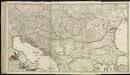
[79][79]Regni Hungariae, ..., uit: Atlas sive Descriptio terrarum orbis
Annotatie: Gedigitaliseerde versie. Amsterdam. Heiloo : Picturae (vervaardiger), 2015. tiff-bestand. Gedigitaliseerd: 07-01-2015; Origineel: Universiteitsbibliotheek Vrije Universiteit (XL.05127.-) ; Netherlands; Titelpagina ontbreekt Wit, Frederik de Amsterdam : Frederick de Wit
16 bis. Europa etnografica.
1 : 6000000 Touring club italiano
[Central and southeast Europe]
Evropa jihovýchodní
Polonia Et Ungaria, XV. Nova Tabula. [Karte], in: Claud. Ptolemaeus. Geographia lat. cum mappis [...], S. 398.
1 Karte aus Atlas Münster, Sebastian [und Ptolemaeus, Claudius]
Österreich-Ungarn, Staatenkarte
1 : 4500000 Österreich-Ungarn