Maps of Balkan Pen.
Theatre de la Guerre en Hongrie, Bosnie, Servie, et Tartarie Crimee, en il Grandes Feuilles
1 : 2000000 Mollova mapová sbírka Briffaut, Etienne Briffaut, Etienne
Daciarum, Moesiarumque, Vetus Descriptio. [Karte], in: Theatrum orbis terrarum, S. 505.
1 Karte aus Atlas Ortelius, Abraham Vrients, Jan Baptista
Accurate Landkarte die Königreiche Ober- und Nieder- Hungarn, Slavonien, Croatien, Dalmatien, Bosnien, Servien, Bulgarien, und Romanien, das Groß Fürstenthum Siebenbürgen, die Fürstenthümer Moldau, Wallachen, Bessarabien, die Oczakowisch- und Crimische Tartaren, die pohlnische Provinz Podolien, wie auch ein Theil von Ukranien, und übrige angränzende Ländern vorstellend
1 : 1430000 Besarábie (Moldavsko a Ukrajina) Lidl, Johann Jakob Joh. Jacob Lidl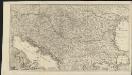
Novissima tabula regni Hungariae et regionum quondam ei unitarum ut Transilvaniae, Valachiae, Moldaviae, Serviae, Romaniae, Bulgariae, Bessarabiae, Croatiae, Bosniae, Dalmatiae, Slavoniae, Morlachiae et reipublicae Ragusanae : accedit pars magna dominii Veneti [...]
1 : 2000000 auctore Reinier & Josua Ottens geographe Amstelodamensi J. Keyser sculpsit Te Amsterdam : by Reinier & Iosua Ottens [...]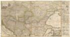
Accurate Landkarte die Königreiche Ober- und Nieder- Hungarn, Slavonien, Croatien, Dalmatien, Bosnien, Servien, Bulgarien und Romanien, das Gross Fürstenthum Siebenbürgen, die Fürstenthümer Moldau, Wallachen, Bessarabien, die Oczakowisch- und Crimische Tartaren, die Pohlnische Provinz Podolien, wie auch ein Theil von Ukranien, und übrige angränzende Ländere vorstellend
1 : 1430000 Besarábie (Moldavsko a Ukrajina) Lidl, Johann Jakob Joh. Jacob Lidl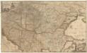
Hungariae
1 : 2600000 Balkánský poloostrov Hase, Johann Matthias Homannianos Heredes
HUNGARIAE ampliori significatu et veteris vel Methodicae, complexae REGNA
1 : 2600000 Bosna Hase, Johann Matthias curantibus Homannianis Heredibus
Hungariae
1 : 2600000 Balkánský poloostrov Hase, Johann Matthias Homannianis Heredibus
Le Royaume De Hongrie, et les Estats qui en ont esté sujets, et qui sont preventement La Partie Septentrionale De La Tourquie En Europe [Karte], in: Atlas nouveau, contenant toutes les parties du monde [...], Bd. 2, S. 197.
1 Karte aus Atlas Sanson, Nicolas Jaillot, Alexis Hubert und Mortier, Pieter
Galizien, Ungarn mit Slavonien und Croatien, Siebenbürgen und Dalmatien, Moldau, Wallachey
Hand-Atlas über alle Theile der Erde nach dem neuesten Zustande und über das Weltgebäude Stieler, Adolf bei Justus Perthes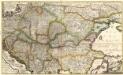
Accurate Landkarte die Königreiche
1 : 1400000 Mollova mapová sbírka Lidl, Johann Jakob Lidl, Johann Jacob
Accurate Landkarte die Königreiche
1 : 1400000 Mollova mapová sbírka Lidl, Johann Jakob Lidl, Johann Jacob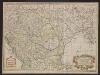
Carte de la Hongrie et partie septentrionale de la Turquie
Ungarn, Osmanisches Reich L'Isle, Guillaume de
Le Royaume de Hongrie et des pays qui en dependoient autrefois ; Nova et accurata Regni Hungariae tabula, ad usum serenissimi Burgundiae ducis
Ungarn, Osmanisches Reich L'Isle, Guillaume de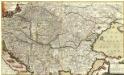
Neu und Accurat vefasste General Post Land-Karte des sehr grossen Welt berühmten Konig-Reichs Hungarn
1 : 1400000 Mollova mapová sbírka Lidl, Johann Jakob Lidl, Johann Jacob
Le Royaume de Hongrie...
Carte geographique representant le théatre de la guerre entre les Russes, les Turcs, et les Polonis Confédérés ...

Tabula Hungaria et regionum, quae praeterea ab ea dependent
1 : 2100000 Maďarsko Delisle, Guillaume Lotter, Georg F. T. C. Lotter
[Ost-Europa in 6 Blättern, Enthaltend: Norwegen, Schweden, Russland, Kaukasien und die Türkei, Blatt 5]
Hand-Atlas über alle Theile der Erde und über das Weltgebäude Stieler, Adolf Justus Perthes
Tabula Hungaria et regionum, quae praeterea ab ea dependent, delineata juxta magnum numerum an[n]otationum et mappas manuscriptas vel impressas
1 : 2600000 Evropa jihovýchodní Delisle, Guillaume Lotter, Georg F. Tob. Conr. Lotter
Tabula Hungaria et regionum, quae praeterea ab ea dependent, delineata juxta magnum numerum an[n]otationum et mappas manuscriptas vel impressas
1 : 2600000 Evropa jihovýchodní Delisle, Guillaume Lotter, Georg F. Tob. Conr. Lotter
Tabula Hungaria et regionum, quae praeterea ab ea dependent, delineata juxta magnum numerum an[n]otationum et mappas manuscriptas vel impressas
1 : 2600000 Evropa jihovýchodní Delisle, Guillaume Lotter, Georg F. Tob. Conr. Lotter
Tabula Hungaria et regionum, quae praaeterea ab ea dependent, delineata juxta magnum numerum an[n]otatium et mappas manuscriptas vel impressas
1 : 2300000 Maďarsko Delisle, Guillaume Lotter, Georg F. T. C. Lotter
Tabula Hungaria et regionum, quae praaeterea ab ea dependent, delineata juxta magnum numerum an[n]otatium et mappas manuscriptas vel impressas
1 : 2300000 Maďarsko Delisle, Guillaume Lotter, Georg F. T. C. Lotter
HVNGARIAE
1 : 860000 Bosna Hase, Johann Matthias curantibus Homannianis Heredibus
Hvngariae
1 : 860000 Bosna Hase, Johann Matthias curantibus Homannianis Heredibus
Hvngariae
1 : 860000 Bosna Hase, Johann Matthias curantibus Homannianis Heredibus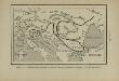
Marche des Ostrogoths à travers l’Europe méridionale
Mitteleuropa Ostgoten Völkerwanderungszeit Völkerwanderung
Carte de la Hongrie
1 : 2500000 Mollova mapová sbírka Delisle, Guillaume Liébaux L'Isle, Guillaume de