Maps of Balkan Pen.

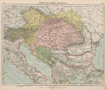
Österreich-Ungarn, Staatenkarte
1 : 4500000 Österreich-Ungarn
Österreich-Ungarn
1 : 4500000 Österreich-Ungarn
Le royaume de Hongrie et les estats qui ont esté vnis a sa couronne
1 : 2870000 Evropa jihovýchodní Jaillot, Alexis-Hubert H. Iaillot
CARTE DU COURS DU DANUBE depuis Ulm jusqu'a son embouchure dans la Mer noire
Dunaj (Rumunsko a Ukrajina : řeka : delta) Artaria & Compagnie
Austria Turkey In Europe And Greece.
1 : 4181760 Johnson, A.J.
Österreich-Ungarn, Staatenkarte
1 : 4500000 Österreich-Ungarn
Südosteuropa mit den von 1919 bis 1938 geltenden Staatsgrenzen
Südosteuropa Grenzen
Österreichisch-Ungarische Monarchie
Handatlas über alle Theile der Erde und über das Weltgebäude Stieler, Adolf Justus Perthes
Le Cours Du Danube Depuis sa Source Iusqu'a ses Embouchures [Karte] Le Bosphore De Thrace [...] [Nebenkarte], in: Atlas nouveau, contenant toutes les parties du monde [...], Bd. 1, S. 249.
1 Karte aus Atlas Sanson, Nicolas Jaillot, Alexis Hubert und Mortier, Pieter
Die Donauländer
1 : 5000000 Österreich-Ungarn, Balkanhalbinsel
Eisenbahn-Karte der oesterreichisch-ungarischen Monarchie
1 : 1228000 Budapešť (Maďarsko : oblast) Beer, Josef A. Hartleben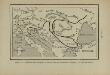
Marche des Ostrogoths à travers l’Europe méridionale
Mitteleuropa Ostgoten Völkerwanderungszeit Völkerwanderung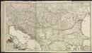
[79][79]Regni Hungariae, ..., uit: Atlas sive Descriptio terrarum orbis
Annotatie: Gedigitaliseerde versie. Amsterdam. Heiloo : Picturae (vervaardiger), 2015. tiff-bestand. Gedigitaliseerd: 07-01-2015; Origineel: Universiteitsbibliotheek Vrije Universiteit (XL.05127.-) ; Netherlands; Titelpagina ontbreekt Wit, Frederik de Amsterdam : Frederick de Wit
Oorlogskaart van Zuid-Oostelijk Europa : (Italië tot de Dardanellen)
1 : 2500000 Annotatie: Ondertitel op omslag: Italiaansch-Oostenrijksche grenzen, gebied der Adriatische Zee, Roemeensch-Hongaarsche grenzen, de Dardanellen Amsterdam : Van Holkema & Warendorf
Artaria's Eisenbahnkarte
1 : 1500000 Evropa jihovýchodní Peucker, Karl Artaria
[Central and southeast Europe]
Evropa jihovýchodní
Map Of The Austrian Empire, Italian States. Turkey In Europe, And Greece.
1 : 7500000 Mitchell, Samuel Augustus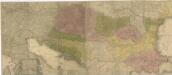
Carte geographique representant le théatre de la guerre entre les Russes, les Turcs, et les Polonis Confédérés ...

Karte der politischen Justiz- und Militär- Verwaltungsbezirke im Kaiserthume Oesterreich
Evropa jihovýchodní Schnabel, Jiří Norbert Machek, A.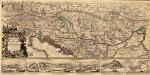
Le Cours du Danvbe depuis sa Source Iusqu'a ses Embouchures
1 : 1900000 Mollova mapová sbírka Sanson, Guillaume Jaillot, Alexis Hubert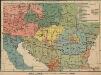
Österreich-Ungarn. Völker
1 : 9000000 Österreich-Ungarn Ethnische Gruppe
Karte der wichtigsten Eisenbahnen Österreich-Ungarns und den angrenzenden Gebiete
1 : 6000000 Rakousko-Uhersko Rothaug, Johann Georg F. Tempsky
Der Oesterreichische Kaiser-Staat
Hand-Atlas über alle Theile der Erde nach dem neuesten Zustande und über das Weltgebäude Stieler, Adolf bei Justus Perthes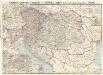
Artaria's Eisenbahn- u. Postkarte von Oesterreich-Ungarn
1 : 1500000 Budapešť (Maďarsko) Artaria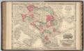
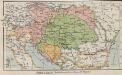
Austria, Turkey, Hungary, Macedonia.
1 : 1532000 Johnson, A.J.
Die Donaustaaten
Österreich-Ungarn. Staaten
1 : 9000000 Österreich-Ungarn Verwaltungsgliederung
Austria, Turkey in Europe, and Greece.
1 : 3920000 Johnson, A.J.
Austria, Turkey in Europe, and Greece.
1 : 3920000 Johnson, A.J.