Maps of Italy

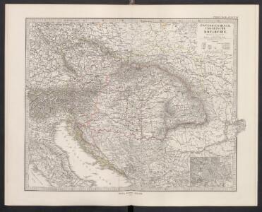
Österreichisch-Ungarische Monarchie
Handatlas über alle Theile der Erde und über das Weltgebäude Stieler, Adolf Justus Perthes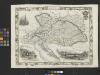
Austria
From Austria
Der Oesterreichische Kaiser-Staat
Hand-Atlas über alle Theile der Erde nach dem neuesten Zustande und über das Weltgebäude Stieler, Adolf bei Justus Perthes
Neuer Atlas der ganzen Erde nach den neuesten Bestimmungen für Zeitungsleser
Uvoz robe i vrijednost za proiyvodnju upotrebljenih sirovina, polutvorina i tvorina kod većih tvornica 1912. Kralj. Hrvatska i Slavonija
Kroatien Slawonien Import Statistik Industrie
Österreich-Ungarn, Staatenkarte
1 : 4500000 Österreich-Ungarn
8. Mittel und Ost-Europa oder Germanien und die illyrischen Provinzen des Römischen Reichs
Römisches Reich, Germanische Provinzen
Le royaume de Hongrie et les estats qui ont esté vnis a sa couronne
1 : 2870000 Evropa jihovýchodní Jaillot, Alexis-Hubert H. Iaillot
Die Donauländer
1 : 5000000 Österreich-Ungarn, Balkanhalbinsel
Le Cours Du Danube Depuis sa Source Iusqu'a ses Embouchures [Karte] Le Bosphore De Thrace [...] [Nebenkarte], in: Atlas nouveau, contenant toutes les parties du monde [...], Bd. 1, S. 249.
1 Karte aus Atlas Sanson, Nicolas Jaillot, Alexis Hubert und Mortier, Pieter
Artaria's Eisenbahnkarte
1 : 1500000 Evropa jihovýchodní Peucker, Karl Artaria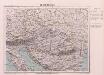
Oesterreich
Österreich-Ungarn
Die Donaustaaten

Uibersichts-Karte v. Oesterreich-Ungarn
1 : 2500000 Rakousko-Uhersko Steinhauser, Anton Artaria
Kohlen-Revier-Karte der österreichisch-ungarischen Monarchie
1 : 2100000 Pechar, Johann In Commission der Buch- und Kunsthandlung C.H. Hunger's Nachfolger (Kosmack & Neugebauer)
Die Donaustaaten
1 : 2500000 Dunaj-oblast Steinhauser, Anton Peucker, Karl Artaria
Galizien, Ungarn mit Slavonien und Croatien, Siebenbürgen und Dalmatien, Moldau, Wallachey
Hand-Atlas über alle Theile der Erde nach dem neuesten Zustande und über das Weltgebäude Stieler, Adolf bei Justus Perthes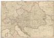
General Karte des Österreichischen Erb-Kaiserthums
1 : 2470000 Evropa jihovýchodní Mollo, Tranquillo T. Mollo
Karte der wichtigsten Eisenbahnen Österreich-Ungarns und den angrenzenden Gebiete
1 : 6000000 Rakousko-Uhersko Rothaug, Johann Georg F. Tempsky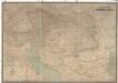
Hölzels Verkehrskarte von Österreich-Ungarn
1 : 800000 Rakousko-Uhersko Kallina, Leopold Hölzel, Eduard Ed. Hölzels geogr. Institut
Central Europe.
1 : 7303000 Fisher, Richard Swainson
Österreich-Ungarn, Staatenkarte
1 : 4500000 Österreich-Ungarn
Kaisertum Österreich 1805 nach dem Frieden von Pressburg
Österreich Preßburg / Friede <1805> Kunz, Andreas ; Moeschl, Joachim Robert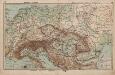
Mittel-Europa Österreich-Ungarn. Naturkarte
1 : 5000000 Mitteleuropa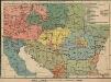
Österreich-Ungarn. Völker
1 : 9000000 Österreich-Ungarn Ethnische Gruppe
Österreich-Ungarn
1 : 4500000 Österreich-Ungarn
[Central and southeast Europe]
Evropa jihovýchodní
Österreich
Neuer Handatlas über alle Theile der Erde Kiepert, Heinrich Verlag von Dietrich Reimer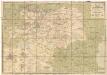
Eisenbahn-Karte der oesterreichisch-ungarischen Monarchie
1 : 1228000 Budapešť (Maďarsko : oblast) Beer, Josef A. Hartleben