Maps of Ukraine

Europ. Russland
Stieler's Hand-Atlas Stieler, Adolf bei Justus Perthes
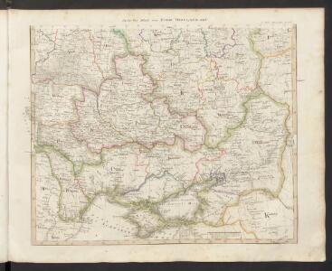
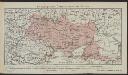
Südliches Blatt vom Europ. Russland
Hand-Atlas über alle Theile der Erde nach dem neuesten Zustande und über das Weltgebäude Stieler, Adolf bei Justus Perthes
[Europäisches Russland, Südliches Blatt]
Hand-Atlas über alle Theile der Erde nach dem neuesten Zustande und über das Weltgebäude Stieler, Adolf bei Justus Perthes
Nouveau théatre de la guerre entre les Turcs et les Russes et l'Empereur
1 : 4500000 Petit sculp.
Cvmania Magna olim Hvnnia Orientalis
1 : 6500000 Mollova mapová sbírka
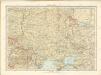
Reliefkarte der Ukraine und Krim
Ukraine, Krim
S. Russia in Europe.
1 : 8900000 Seaman, James V.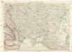
Karte der Ukraine
1 : 2000000 Ukrajina Freytag-Berndt u. Artaria
Taurica Chersonesus. Nostra aetate Przecopsca et Gazara dicitur [Karte], in: Gerardi Mercatoris Atlas, sive, Cosmographicae meditationes de fabrica mundi et fabricati figura, S. 167.
1 Karte aus Atlas Mercator, Gerhard Montanus, Petrus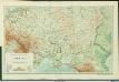
Physische Übersichtskarte der Ukraina und der angrenzenden Länder
1 : 5000000 Ukraine Geologie Kartogr. Anstalt G. Freytag & Berndt, Ges. m. b. H., Wien
[XIV], uit: Geognostische Karte des Oesterreichischen Kaiserstaates mit einem grossen Theile Deutschland's u. Italien / hauptsachlich nach ... Haidinger's geognostischer Karte dieses Staates bearb. von Josef Scheda
1 : 3000000 titelvariant: General-Karte von Europa in 25 Blättern; Annotatie: Bijlage bij: General-Karte von Europa in 25 Blättern. - 1:2.592.000. - 1845-1847 Scheda, Joseph Wien : K.K. Militär. Geografisch. Institut
Ruszland, Verbreitung der deutschen Sprache
Russland / Europäischer Teil Sprachverbreitung, Deutsch
UKRANIA seu COSACORUM Regio Walachia item Moldavia et Tartaria minor
1 : 4600000 Moldávie (historické území) Weigel, Christoph exc. Christ. Weigelio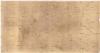
[Ukrajina - vrstevnice a říční síť]
Ukrajina
Ukraine. Ethnographische Karte des einheitlichen ukrainischen Gebiets ohne Enklaven
1 : 8000000 Ukraine Ethnische Gruppe
Sovětský svaz v mapách

Plan von der Krim und der Nogdyschen und Kubanschen Tatarey
1 : 7420000 Krym (Ukrajina)
71-72. Ucraina, Mar Nero.
1 : 3000000 Touring club italiano
Pflanzengeographische Übersichtskarte der Ukraina
1 : 10000000 Ukraine Pflanzengeografie Kartogr. Anstalt G. Freytag & Berndt, Ges. m. b. H., Wien
Klimatische Übersichtskarte der Ukraina
1 : 10000000 Ukraine Klima Kartogr. Anstalt G. Freytag & Berndt, Ges. m. b. H., Wien
Geologische Übersichtskarte der Ukraina
1 : 10000000 Ukraine Geologie Kartogr. Anstalt G. Freytag & Berndt, Ges. m. b. H., Wien
Theatre de la guerre sur les frontieres entre les deux grands monarques de Russie & de Turquie ou carte nouvelle d'une grande partie de la Russie ou l'on a la Petite Tartarie, l'Ukraine la Crimée & le pais des Cosaques la mer de Azof & la Mer Noire & les pais circomvoisins
1 : 3000000 Azovské moře (Ukrajina a Rusko) Ottens, Reinier Ottens, Josua par R. & I. Ottens

Tektonisch-morphologische Übersichtskarte der Ukraina
1 : 10000000 Ukraine Geologie Tektonik Kartogr. Anstalt G. Freytag & Berndt, Ges. m. b. H., Wien
Ethnographische Übersichtskarte der Ukraina
1 : 7500000 Ukraine Ethnische Gruppe Kartogr. Anstalt G. Freytag & Berndt, Ges. m. b. H., Wien
Taurica Chersonesus. Nostra aetate Przecopsca et Gazara dicitur [Karte], in: Atlas, sive, Cosmographicae meditationes de fabrica mundi et fabricati figura, S. 162.
1 Karte aus Atlas Mercator, Gerhard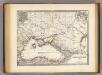
Pontus Euxinus et quae ei adjacent.
1 : 4500000 Menke, Th.