Maps of Pontic Steppe

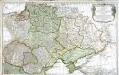
UKRANIA seu COSACORUM Regio Walachia item Moldavia et Tartaria minor
1 : 4600000 Moldávie (historické území) Weigel, Christoph exc. Christ. Weigelio
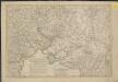
Theatre de la guerre actuelle, comprenant la Prusse, la Pologne, une grande partie de la Russie & de la Turque Européenne et Asiatique jusqu'á la mer Caspienne
1 : 3330000 Kaspické moře-oblast Bonne, Rigobert Treuttel & Witz

[Východní Evropa]
Evropa východní
Ukrania seu Cosacorum Regio Walachia item Moldavia et Tartaria minor / exc. Christ. Weigelio ; M. Ka
1 : 4600000 1 Karte : Kupferdruck ; 33 x 39 cm Kauffer, Michael Weigel
Ukrania quae et Terra Cosaccorum / exhibita à Ioh. Baptista Homanno
1 : 3200000 1 Karte : Kupferdruck ; 46 x 56 cm Homann, Johann Baptist [Homann]
Europe Orientale, Feuille Sud.
1 : 5000000 Vivien St Martin, L.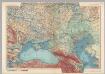
U.S.S.R. in Europe - South. Pergamon World Atlas.
1 : 5000000 Polish Army Topography Service
[Střední a východní Evropa]
Evropa střední
[Střední a východní Evropa]
Evropa střední
Vkrania quae et terra Cosaccorvm cum vicinis Walachiae, Moldaviae, minoris. Tartariae provinciis
1 : 3250000 Moldavsko Homann, Johann Baptist a Ioh. Baptista Homanno
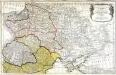
Vkrania quae et terra Cosaccorvm cum vicinis Walachiae, Moldaviae, minorisq[ue] Tartariae provinciis
1 : 3250000 Moldavsko Homann, Johann Baptist a Ioh. Baptista Homanno
Taurica Chersonesus. Nostra aetate Przecopsca et Gazara dicitur [Karte], in: Gerardi Mercatoris Atlas, sive, Cosmographicae meditationes de fabrica mundi et fabricati figura, S. 167.
1 Karte aus Atlas Mercator, Gerhard Montanus, Petrus
Administrativnaja Karta Evropejskoj časti C.C.C.P.
Nouveau théatre de la guerre entre les Turcs et les Russes et l'Empereur
1 : 4500000 Petit sculp.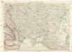
Karte der Ukraine
1 : 2000000 Ukrajina Freytag-Berndt u. Artaria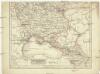
Eur. Russland
Rusko jižní
Assoph, Azow oder Azak, mit der Kleinen Tartarey, dem Schwarzen Meer und denen Russisch oder Moscowi
1 : 12000000 1 Karte : Kupferdruck ; 14 x 21 cm Bodenehr, Gabriel [Verlag nicht ermittelbar]
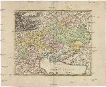
Theatre de la guerre sur les frontieres entre les deux grands monarques de Russie & de Turquie ou carte nouvelle d'une grande partie de la Russie ou l'on a la Petite Tartarie, l'Ukraine la Crimée & le pais des Cosaques la mer de Azof & la Mer Noire & les pais circomvoisins
1 : 3000000 Azovské moře (Ukrajina a Rusko) Ottens, Reinier Ottens, Josua par R. & I. Ottens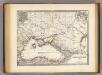
Pontus Euxinus et quae ei adjacent.
1 : 4500000 Menke, Th.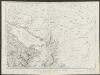
Taurica Chersonesus, Nostra aetate Przecopsca, et Gazara dicitur. [Karte], in: Theatrum orbis terrarum, sive, Atlas novus, Bd. 1, S. 82.
1 Karte aus Atlas Blaeu, Joan Blaeu, Willem Janszoon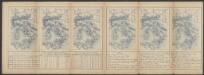
Taurica Chersonesus, Nostra aetate Przecopsca, et Gazara dicitur. [Karte], in: Le théâtre du monde, ou, Nouvel atlas contenant les chartes et descriptions de tous les païs de la terre, Bd. 1, S. 80.
1 Karte aus Atlas Blaeu, Willem Janszoon und Blaeu, Joan Blaeu, Willem Janszoon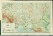
Physische Übersichtskarte der Ukraina und der angrenzenden Länder
1 : 5000000 Ukraine Geologie Kartogr. Anstalt G. Freytag & Berndt, Ges. m. b. H., Wien
Ruszland, Verbreitung der deutschen Sprache
Russland / Europäischer Teil Sprachverbreitung, Deutsch
Taurica Chersonesus, Nostra aetate Przecopsca, et Gazara dicitur. [Karte], in: Novus Atlas, das ist, Weltbeschreibung, Bd. 1, S. 66.
1 Karte aus Atlas Blaeu, Joan Blaeu, Willem Janszoon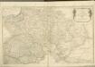

Die Slaven nördlich von der Donau um 900
1 : 21000000 Osteuropa Slawen
Dritter Theil der Karte von Europa welcher das südliche Russland Polen und Ungarn die europæische, und beinahe die ganze asiatische Türkei enthælt, 1
1 Blatt : 54 x 83 cm F.A. Schrämbl