Maps of Pontic Steppe


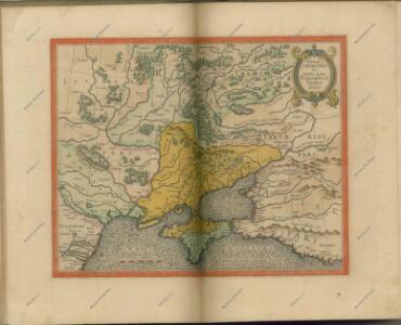
Taurica Chersonesus. Nostra aetate Przecopsca et Gazara dicitur [Karte], in: Atlas, sive, Cosmographicae meditationes de fabrica mundi et fabricati figura, S. 162.
1 Karte aus Atlas Mercator, Gerhard
Theatre de la guerre sur les frontieres entre les deux grands monarques de Russie & de Turquie ou carte nouvelle d'une grande partie de la Russie ou l'on a la Petite Tartarie, l'Ukraine la Crimée & le pais des Cosaques la mer de Azof & la Mer Noire & les pais circomvoisins
1 : 3000000 Azovské moře (Ukrajina a Rusko) Ottens, Reinier Ottens, Josua par R. & I. Ottens
Taurica Chersonesus. Nostra aetate Przecopsca et Gazara dicitur [Karte], in: Gerardi Mercatoris Atlas, sive, Cosmographicae meditationes de fabrica mundi et fabricati figura, S. 167.
1 Karte aus Atlas Mercator, Gerhard Montanus, Petrus
Tabula Geographica QUA PARS RUSSIAE MAGNAE, PONTUS EUXINUS seu MARE NIGRUM et TARTARIA MINOR
1 : 3000000 Anatolie (Turecko) Homann, Johann Baptist a Ioh. Baptista Homanno
Tabula geographica qua pars Russiae Magnae, Pontus Euxinus seu Mare Nigrum et Tauriae Regnum cum finitimis Bulgariae, Romaniae et Natoliae provincis exhibetur
1 : 3000000 Anatolie (Turecko) Homann, Johann Baptist a Ioh. Baptista Homanno

71-72. Ucraina, Mar Nero.
1 : 3000000 Touring club italiano
Tabula geographica qua pars Russiae magnae, pontus Euxinus seu mare Nigrum et Tartaria minor / a Ioh
1 : 3100000 1 Karte : Kupferdruck ; 57 x 47 cm Homann, Johann Baptist [Johann Baptist Homann]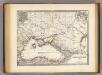
Pontus Euxinus et quae ei adjacent.
1 : 4500000 Menke, Th.
UKRANIA seu COSACORUM Regio Walachia item Moldavia et Tartaria minor
1 : 4600000 Moldávie (historické území) Weigel, Christoph exc. Christ. Weigelio
Assoph, Azow oder Azak, mit der Kleinen Tartarey, dem Schwarzen Meer und denen Russisch oder Moscowi
1 : 12000000 1 Karte : Kupferdruck ; 14 x 21 cm Bodenehr, Gabriel [Verlag nicht ermittelbar]
Ukrania quae et Terra Cosaccorum / exhibita à Ioh. Baptista Homanno
1 : 3200000 1 Karte : Kupferdruck ; 46 x 56 cm Homann, Johann Baptist [Homann]
Ukrania seu Cosacorum Regio Walachia item Moldavia et Tartaria minor / exc. Christ. Weigelio ; M. Ka
1 : 4600000 1 Karte : Kupferdruck ; 33 x 39 cm Kauffer, Michael Weigel
Partie méridionale de la Russie européenne / par le Sr. Robert de Vaugondy fils géographe ordinai
1 : 3400000 1 Karte auf 2 Blatt : Kupferdruck ; 47 x 59 cm Robert de Vaugondy, Didier [Verlag nicht ermittelbar]
Taurica Chersonesus, Nostra aetate Przecopsca, et Gazara dicitur. [Karte], in: Novus Atlas, das ist, Weltbeschreibung, Bd. 1, S. 66.
1 Karte aus Atlas Blaeu, Joan Blaeu, Willem Janszoon
Taurica Chersonesus, Nostra aetate Przecopsca, et Gazara dicitur. [Karte], in: Le théâtre du monde, ou, Nouvel atlas contenant les chartes et descriptions de tous les païs de la terre, Bd. 1, S. 80.
1 Karte aus Atlas Blaeu, Willem Janszoon und Blaeu, Joan Blaeu, Willem Janszoon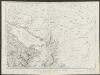
Taurica Chersonesus, Nostra aetate Przecopsca, et Gazara dicitur. [Karte], in: Theatrum orbis terrarum, sive, Atlas novus, Bd. 1, S. 82.
1 Karte aus Atlas Blaeu, Joan Blaeu, Willem Janszoon
TAVRICA CHERSONESVS | Nostra ætate | PRZECOPSCA, | et GAZARA dicitur.
[Amsterdam : Joan Blaeu]
[Europäisches Russland, Südliches Blatt]
Hand-Atlas über alle Theile der Erde nach dem neuesten Zustande und über das Weltgebäude Stieler, Adolf bei Justus Perthes
Cvmania Magna olim Hvnnia Orientalis
1 : 6500000 Mollova mapová sbírka
Vkrania quae et terra Cosaccorvm cum vicinis Walachiae, Moldaviae, minoris. Tartariae provinciis
1 : 3250000 Moldavsko Homann, Johann Baptist a Ioh. Baptista Homanno
Vkrania quae et terra Cosaccorvm cum vicinis Walachiae, Moldaviae, minorisq[ue] Tartariae provinciis
1 : 3250000 Moldavsko Homann, Johann Baptist a Ioh. Baptista Homanno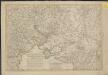
Nouveau théatre de la guerre entre les Turcs et les Russes et l'Empereur
1 : 4500000 Petit sculp.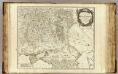
Russie Europeenne nord.
1 : 3400000 Robert de Vaugondy, Gilles, 1688-1766
Plan von der Krim und der Nogdyschen und Kubanschen Tatarey
1 : 7420000 Krym (Ukrajina)
S. Russia in Europe.
1 : 8900000 Seaman, James V.
Russiae magnae Pontus Euxinus seu Mare Nigrum et Tartaria minor
1 : 3000000 Rusko západní Homann, Johann Baptist I. B. Homann