Maps of Bezirk Liezen
Militair Karte von Süd-Deutschland in 20 Sectionen
1 : 400000 16. Section Coulon, Alois von A. von Coulon
Plan des Bergwergs Nabloch und Hirn
Mollova mapová sbírka Geyer
Archiducatus Austriae Superioris. Ober Österreich
1 : 550000 Mollova mapová sbírka Suttinger, Johann Baptist Merian, Matthäus
Der oestlicher Theil von Obersteyermark oder der Brucker Kreis
1 : 250000 Horní Rakousko (Rakousko) Kindermann, Joseph Karl Junker, Christoph Franz Xaver Miller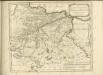

Charte des Traun Viertels in dem Erzherzogthume Niederöstreich uiber der Enns
1 : 440000 Dolní Rakousko (Rakousko) Liechtenstern, Joseph Marx von Bendovsky, Thomas bey Joh. Schönberg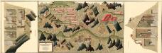
Plan des silber und blei Bergwergs Drul und Mitterdorf, in ober Crain Freiherrn von Rastern
Mollova mapová sbírka Geyer
Linz 145, uit: Special-Karte von Mittel-Europa / nach amtlichen Quellen bearbeitet von W. Liebenow
1 : 300000 titelvariant: W. Liebenow's Mittel-Europa; Annotatie: Titel boven de bladen: W. Liebenow's Mittel-Europa Johannes Wilhelm Liebenow 1822-1897 Frankfurt a. M. : Ludwig Ravenstein
Secundus Ouadrans Das Traun-Viertl
1 : 930000 Mollova mapová sbírka Fuhrmann, Mathias Märtin, Johann Heinrich Heyinger, Johann Ignaz
Secundus Ouadrans Das Traun-Viertl
1 : 930000 Mollova mapová sbírka Insprugger, Sebastianus Märtin, Johann Heinrich Schwendimann, Wolfgang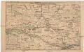
Strecke
Národní park Gesäuse (Rakousko) K. k. Österreichische Staatsbahnen
Carte topographique d'Allemagne contenant une partie de l'Autriche superieur [et] du duche de Stirie [et]c
1 Karte : Kupferdruck ; 45 x 63 cm Jaeger Jäger
Umgebung von Steyer, Waidhofen, Windischgarsten, Admont
1 : 129600 Admont (Rakousko) Maschek, Rudolf Artaria
Neueste special Karte des Judenburger Kreises im Herzogthume Steyermark
1 : 210000 Štýrsko (Rakousko) Kaiser, Jos. Fr. Jos. Fr. Kaiser
Neueste special Karte des Judenburger Kreises im Herzogthume Steyermark
1 : 216000 Štýrsko (Rakousko) Kaiser, Joseph Franz Jos. Fr. Kaiser
Reisekarte des Salzkammergutes und der angrenzenden Gebiete
1 : 100000 Solná komora (Rakousko) Mally, Em. Section Austria
Primus Quadrans Das Hausruck-Viertl
1 : 930000 Mollova mapová sbírka Fuhrmann, Mathias Märtin, Johann Heinrich Heyinger, Johann Ignaz
Primus Quadrans Das Hausruck-Viertl
1 : 930000 Mollova mapová sbírka Insprugger, Sebastianus Märtin, Johann Heinrich Schwendimann, Wolfgang
Der œstliche Theil von Obersteyermark oder der Brucker Kreis
1 Karte : Kupferdruck ; 46 x 54 cm Kindermann; Miller; Junker verlegt bey Franz Xaver Miller Buchhændlern
Umgebung von Maria Zell - Weichselboden - Eisenerz
1 : 129600 Eisenerz (Rakousko) Maschek, Rudolf Artaria
Stÿriae Ducatus Fertilisimi Nova Geographica Descriptio
1 : 200000 Mollova mapová sbírka Vischer, Georg Matthaeus Trost, Andreas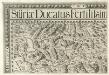
Stÿriae Ducatus Fertilisimi Nova Geographica Descriptio
1 : 200000 Mollova mapová sbírka Vischer, Georg Matthaeus Trost, Andreas
Karte von Gesäuse und Ennsthal
1 : 75000 Enns (Rakousko : řeka : oblast) R. Lechner
Karte des Salzkammergutes
1 : 75000 Solná komora (Rakousko) R. Lechner
Karte des Salzkammergutes
1 : 75000 Solná komora (Rakousko) R. Lechner
Weyer.
from Spezialkarte der osterreichisch-ungarischen Monarchie.
Gaming und Mariazell.
from Spezialkarte der osterreichisch-ungarischen Monarchie.
G. Freytag ́s touristen Wanderkarte: Blat IV. Hochschwab

Kirchdorf.
from Spezialkarte der osterreichisch-ungarischen Monarchie.