Maps of Bezirk Bruck-Mürzzuschlag

Der œstliche Theil von Obersteyermark oder der Brucker Kreis
1 Karte : Kupferdruck ; 46 x 54 cm Kindermann; Miller; Junker verlegt bey Franz Xaver Miller Buchhændlern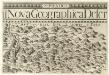
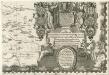
Stÿriae Ducatus Fertilisimi Nova Geographica Descriptio
1 : 200000 Mollova mapová sbírka Vischer, Georg Matthaeus Trost, Andreas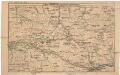
Strecke
Národní park Gesäuse (Rakousko) K. k. Österreichische Staatsbahnen
G. Freytag ́s touristen Wanderkarte: Blat IV. Hochschwab

Murzzuschlag.
from Spezialkarte der osterreichisch-ungarischen Monarchie.
Eisenerz, Wildalpe und Aflenz.
from Spezialkarte der osterreichisch-ungarischen Monarchie.
Umgebung von Maria Zell - Weichselboden - Eisenerz
1 : 129600 Eisenerz (Rakousko) Maschek, Rudolf Artaria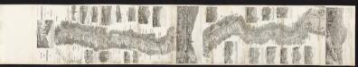
Panorama der kais. koenigl. Staatseisenbahn von Mürzzuschlag bis Gratz
Karl Hölzl, Buchhändler
Karte der Hochschwab und Oetcher-Gruppe

Birkfeld.
from Spezialkarte der osterreichisch-ungarischen Monarchie.
Leoben und Bruck a.d. Mur.
from Spezialkarte der osterreichisch-ungarischen Monarchie.
Umgebung von Krieglach
1 : 43000
Gebiet der Schneealpe
1 : 50000 Kartographisches Institut
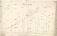
Situation und Längenprofil der k.k. Staatseisenbahn von Gloggnitz bis Mürzzuschlag über den Semmering
1 : 46000 Lechner
Admont und Hieflau.
from Spezialkarte der osterreichisch-ungarischen Monarchie.
Semmering - Gebiet
Archiducatus Austriae inferioris Geographica, et Nouiter Emendata Accuratissima Descriptio] :
1 : 153333 Mollova mapová sbírka Vischer, Georg Matthaeus Hoffmann, Jakob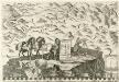
Archiducatus Austriae inferioris Geographica, et Nouiter Emendata Accuratissima Descriptio :
1 : 153333 Mollova mapová sbírka Vischer, Georg Matthaeus Hoffmann, Jakob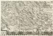
Archiducatus Austriae inferioris Geographica, et Nouiter Emendata Accuratissima Descriptio :
1 : 153333 Mollova mapová sbírka Vischer, Georg Matthaeus Hoffmann, Jakob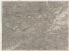
Schneeberg & Raxalpe
1 : 75000 Alpy rakouské (pohoří) Artaria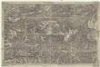
Umgebung von Neuberg
1 : 42000 Baden (Rakousko)
Freytag & Berndt's Ausflugskarte
1 : 100000 Alpy rakouské (pohoří : oblast) Kartogr. Anst. Freytag & Berndt
Gesäuse
General-Längen-Profil der k. k. Staats-Eisenbahn von Gloggnitz bis Mürzzuschlag
Gloggnitz-Mürzzuschlag (Rakousko : železniční trať)
G. Freytag ́s Ausflugskarte
1 : 100000 Rakousko Freytag, Gustav Freytag & Berndt
Schneeberg, Raxalpe & Semmering
1 : 37500 Südwest-Blatt Pauliny, Jacob Josef Pauliny
Spital am Semmering
1 : 25000 Kartographisches Institut
Mürzzuschlag
1 : 25000 Mürzzuschlag (Rakousko) Kartographisches Institut
Kapellen
1 : 25000 Kartographisches Institut


