Maps of Tragöß-Sankt Katharein

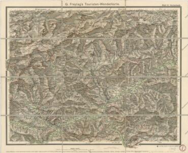
G. Freytag ́s touristen Wanderkarte: Blat IV. Hochschwab

Eisenerz, Wildalpe und Aflenz.
from Spezialkarte der osterreichisch-ungarischen Monarchie.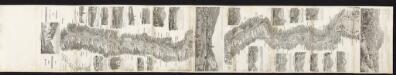
Panorama der kais. koenigl. Staatseisenbahn von Mürzzuschlag bis Gratz
Karl Hölzl, Buchhändler
Umgebung von Krieglach
1 : 43000
Der œstliche Theil von Obersteyermark oder der Brucker Kreis
1 Karte : Kupferdruck ; 46 x 54 cm Kindermann; Miller; Junker verlegt bey Franz Xaver Miller Buchhændlern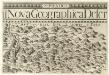
Stÿriae Ducatus Fertilisimi Nova Geographica Descriptio
1 : 200000 Mollova mapová sbírka Vischer, Georg Matthaeus Trost, Andreas
Umgebung von Maria Zell - Weichselboden - Eisenerz
1 : 129600 Eisenerz (Rakousko) Maschek, Rudolf Artaria
Leoben und Bruck a.d. Mur.
from Spezialkarte der osterreichisch-ungarischen Monarchie.
Murzzuschlag.
from Spezialkarte der osterreichisch-ungarischen Monarchie.
Karte der Hochschwab und Oetcher-Gruppe

Birkfeld.
from Spezialkarte der osterreichisch-ungarischen Monarchie.
Gebiet der Schneealpe
1 : 50000 Kartographisches Institut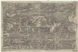
Umgebung von Neuberg
1 : 42000 Baden (Rakousko)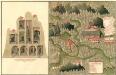
Plan des C. und 5. Bergwerg St. Ulrich an Unter Frauen Bach in Hutthal, in Unter Carnt;
Mollova mapová sbírka Geyer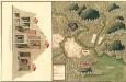
Plan des in Ober Carnten Gold Bergwergs Velach
Mollova mapová sbírka Geyer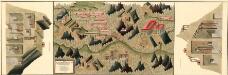
Plan des silber und blei Bergwergs Drul und Mitterdorf, in ober Crain Freiherrn von Rastern
Mollova mapová sbírka Geyer
Verschiebung der Bevölkerung 1910-1920/23
Mittelsteiermark Bevölkerungsentwicklung
Der noerdliche Theil von Untersteyermark oder der Graetzer Kreis
1 : 250000 Dolní Rakousko (Rakousko) Kindermann, Joseph Karl Junker, Christoph Franz Xaver Miller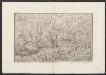
Militair Karte von Süd-Deutschland in 20 Sectionen
1 : 400000 16. Section Coulon, Alois von A. von Coulon
Wirtschaftskarte
Mittelsteiermark Wirtschaft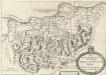
Des Ertzhertzigtumbs Viertl ob Wiener wald. Dis Viertl hat weid und Vich Zucht Auch vil weins und traides frucht
Mollova mapová sbírka Vischer, Georg Matthaeus
Der Noerdliche Theil von Untersteyermark oder der Graetzer Kreis
1 : 260000 Rakousko Kindermann, Joseph Karl Junker, Christoph bey Franz Xaver Miller
Plan des Bergwergs Nabloch und Hirn
Mollova mapová sbírka Geyer
Das in dem Ertzhertzogtumb Vnter Osterreich.
1 : 250000 Mollova mapová sbírka Vischer, Georg Matthaeus Hoffmann, Jakob
Das in dem Ertzhertzogtumb Vnter Osterreich.
1 : 250000 Mollova mapová sbírka Vischer, Georg Matthaeus Hoffmann, Jakob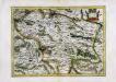
Stiria
1 Karte : Kupferdruck ; 29 x 40 cm Mercator; Hondius Henricus Hondius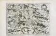
Stiria
1 Karte : Kupferdruck ; 29 x 40 cm Mercator s.n.

Vermehrte und Verbesserte Landkarten des Königreichs Ungarn :
1 : 500000 Mollova mapová sbírka Stier, Martin Böner, Johann-Alexander Endter, Martin