Maps of Bezirk Bruck-Mürzzuschlag
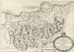
Stÿriae Ducatus Fertilisimi Nova Geographica Descriptio
1 : 200000 Mollova mapová sbírka Vischer, Georg Matthaeus Trost, Andreas
Eisenerz, Wildalpe und Aflenz.
from Spezialkarte der osterreichisch-ungarischen Monarchie.
G. Freytag ́s touristen Wanderkarte: Blat IV. Hochschwab
Karte der Hochschwab und Oetcher-Gruppe
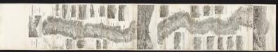
Panorama der kais. koenigl. Staatseisenbahn von Mürzzuschlag bis Gratz
Karl Hölzl, Buchhändler
Murzzuschlag.
from Spezialkarte der osterreichisch-ungarischen Monarchie.
Admont und Hieflau.
from Spezialkarte der osterreichisch-ungarischen Monarchie.
Umgebung von Krieglach
1 : 43000
Umgebung von Neuberg
1 : 42000 Baden (Rakousko)
Gesäuse

Gebiet der Schneealpe
1 : 50000 Kartographisches Institut
Kapellen
1 : 25000 Kartographisches Institut
Mürzzuschlag
1 : 25000 Mürzzuschlag (Rakousko) Kartographisches Institut
Der œstliche Theil von Obersteyermark oder der Brucker Kreis
1 Karte : Kupferdruck ; 46 x 54 cm Kindermann; Miller; Junker verlegt bey Franz Xaver Miller Buchhændlern
Der oestlicher Theil von Obersteyermark oder der Brucker Kreis
1 : 250000 Horní Rakousko (Rakousko) Kindermann, Joseph Karl Junker, Christoph Franz Xaver Miller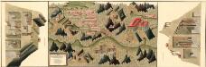
Plan des silber und blei Bergwergs Drul und Mitterdorf, in ober Crain Freiherrn von Rastern
Mollova mapová sbírka Geyer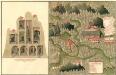
Plan des C. und 5. Bergwerg St. Ulrich an Unter Frauen Bach in Hutthal, in Unter Carnt;
Mollova mapová sbírka Geyer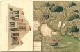
Plan des in Ober Carnten Gold Bergwergs Velach
Mollova mapová sbírka Geyer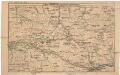
Strecke
Národní park Gesäuse (Rakousko) K. k. Österreichische Staatsbahnen
Umgebung von Maria Zell - Weichselboden - Eisenerz
1 : 129600 Eisenerz (Rakousko) Maschek, Rudolf Artaria
Leoben und Bruck a.d. Mur.
from Spezialkarte der osterreichisch-ungarischen Monarchie.
Karte von Gesäuse und Ennsthal
1 : 75000 Enns (Rakousko : řeka : oblast) R. Lechner
Birkfeld.
from Spezialkarte der osterreichisch-ungarischen Monarchie.
St. Johann am Tauern.
from Spezialkarte der osterreichisch-ungarischen Monarchie.
Gaming und Mariazell.
from Spezialkarte der osterreichisch-ungarischen Monarchie.
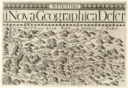
Archiducatus Austriae Superioris Geographica Descriptio. facta Anno 1667
1 : 150000 Mollova mapová sbírka Vischer, Georg Matthaeus Küssel, Melchior
Umgebungskarte von Mariazell
1 : 30000 Ullman Kartographischen Institute
Umgebungskarte von Mariazell
1 : 30000 Ullmann vom Kartographischen, früher Militärgeographischen Institute
Schneeberg, Raxalpe & Semmering
1 : 37500 Südwest-Blatt Pauliny, Jacob Josef Pauliny