Maps of Malay Archipelago

Ost-Asien
Neuer Handatlas über alle Theile der Erde Kiepert, Heinrich Verlag von Dietrich Reimer
Ost-Asien / Neubearb. von Richard Kiepert und Paul Sprigade
1 : 12000000 Richard Kiepert 1846-1915; Paul Sprigade Berlin : Dietrich Reimer (Ernst Vohsen)
Ostasiatischer-Raum
1 : 10000000 Asie východní Bibliographisches Institut
Asie 2.
1 : 7150000 Anville, Jean Baptiste Bourguignon d, 1697-1782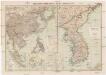
Russisch-Japanischer Kriegsschauplatz
1 : 12000000 Japonsko Kiepert, Richard Sprigade, Paul Dietrich Reimer
Ost-Asien
1 : 12000000 Asie východní Kiepert, Richard Sprigade, Paul Geographische Verlagshandlung Dietrich Reimer (Ernst Vohsen)
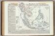
Ostindien und China
E. von Sydow's Schul-Atlas in sechs und dreissig Karten Sydow, Emil von bei Justus Perthes
Java-China-Japan Lyn / specially prep. by Edward Stanford Ltd.
1 : 6969600 Annotatie: Met afstandentabel (in zeemijlen) Stanford's Geographical Establishment, Londen London : Stanford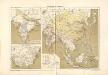
Atlas für Industrie- und Handelsgeographie: Für commercielle und technische Lehranstalten, für Kaufleute und Industrielle

Ostindien und China
1 : 25000000 Himálaj Kocen, Blaž Eduard Hölzel
Indiae orientalis, nec non insularum adiacentium nova descriptio
1 : 15000000 Asie jihovýchodní Visscher, Nicolaes Jansz.
Indiae orientalis, nec non insularum adiacentium nova descriptio
1 : 15000000 Asie jihovýchodní Visscher, Nicolaus per Nicolaum Visscher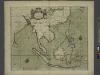
A chart of the eastermost part of the EAST INDIES and CHINA, from cape comarine to IAPAN, with all adjacent Islands
from The sea-atlas : containing an hydrographical description of most of the sea-coasts of the known parts of the world.
Ost-Indien.
1 : 18500000 Stulpnagel, F.v.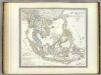
Hinter Indien.
1 : 10000000 Weiland, C. F. (Carl Ferdinand), d. 1847
Ostindien & China
Atlas der Hydrographie Berghaus, Hermann Justus Perthes
Ost-Indien
Hand-Atlas über alle Theile der Erde und über das Weltgebäude Stieler, Adolf Justus Perthes
Hinterindien nebst den Hinterindischen Inseln
1 : 10000000 entworfen und gezeichnet im Jahre 1826 von C. F. Weiland, nach Crawfurd, Kolf und Krusenstern umgearb. und berichtigt 1832, und im Jahre 1838, abermals nach Raffles und Berghaus' Atlas von Asien theilweis umgearb. und berichtigt Weimar : Verlag des Geograph. Instituts
Ost-Indien
Handatlas über alle Theile der Erde und über das Weltgebäude Stieler, Adolf Justus Perthes
Ost-Indien mit den Inseln
Hand-Atlas über alle Theile der Erde nach dem neuesten Zustande und über das Weltgebäude Stieler, Adolf bei Justus Perthes
Malesia ossia Arcipelago Indiano, ed India-Transgangetica.
1 : 11300000 Marzolla, Benedetto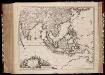
Indiae Orientalis nec non insularum adiacentium nova descriptio / Per Nicolaum Visscher
1 : 15000000 Annotatie: Privilege: Cum privilegio Ordinum Hollandiae et Westfrisiae; Origineel is Blad 188 in atlas factice; Eerste staat. Later is deze kaart uitgegeven door Petrus Schenk Junior; Annotatie geografische gegevens: 2 schaalstokken, o.a. 150 Milliaria Germanica (=7,4 cm) [Amsterdam : Nicolaus Visscher]
Indiæ orientalis, nec non insularum adiacentium nova descriptio / per Nicolaum Visscher
1 : 15000000 1 Karte : Kupferdruck ; 45 x 55 cm [Nicolaes Visscher]
South Eastern Asia.
1 : 16600000 Sharpe, J.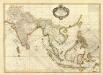
Composite: Indes.
1 : 10000000 Bonne, Rigobert, 1727-1794
Carte d'une partie de la Chine, les isles Philippines, de la Sonde, Moluques, de Papoesi etc. dressée sur les relations les plus nouvelles
1 : 9000000 I. Condet sc. A Amsterdam : par Covens et Mortier
Ostindien.
1 : 22000000 Reichard, C. G.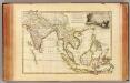
Indes Orientales.
1 : 16250000 Bonne, Rigobert, 1727-1794


