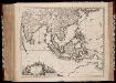
Maps of Malay Archipelago

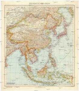
Ostasiatischer-Raum
1 : 10000000 Asie východní Bibliographisches Institut
Asie 2.
1 : 7150000 Anville, Jean Baptiste Bourguignon d, 1697-1782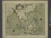
A chart of the eastermost part of the EAST INDIES and CHINA, from cape comarine to IAPAN, with all adjacent Islands
from The sea-atlas : containing an hydrographical description of most of the sea-coasts of the known parts of the world.
Ostindien und China
E. von Sydow's Schul-Atlas in sechs und dreissig Karten Sydow, Emil von bei Justus Perthes
Java-China-Japan Lyn / specially prep. by Edward Stanford Ltd.
1 : 6969600 Annotatie: Met afstandentabel (in zeemijlen) Stanford's Geographical Establishment, Londen London : Stanford
Atlas für Industrie- und Handelsgeographie: Für commercielle und technische Lehranstalten, für Kaufleute und Industrielle

Indiae orientalis, nec non insularum adiacentium nova descriptio
1 : 15000000 Asie jihovýchodní Visscher, Nicolaes Jansz.
Indiae orientalis, nec non insularum adiacentium nova descriptio
1 : 15000000 Asie jihovýchodní Visscher, Nicolaus per Nicolaum Visscher
Ostindien und China
1 : 25000000 Himálaj Kocen, Blaž Eduard Hölzel
Ost-Asien / Neubearb. von Richard Kiepert und Paul Sprigade
1 : 12000000 Richard Kiepert 1846-1915; Paul Sprigade Berlin : Dietrich Reimer (Ernst Vohsen)
Ost-Asien
Neuer Handatlas über alle Theile der Erde Kiepert, Heinrich Verlag von Dietrich Reimer
Orientaliora Indiarum Orientalium cum insulis adjacentibus à promontorio C. Comorin ad Iapan
1 Karte : Kupferdruck ; 43 x 54 cm Renard Louis Renard
[Indischer Ozean, östlicher Teil]
1 Karte : Kupferdruck ; 57 x 45 cm Doncker Hendrik Doncker
Ost-Indien.
1 : 18500000 Stulpnagel, F.v.
Indiae Orientalis, nec non Insularum Adiacentium Nova Descriptio [Karte], in: Novus atlas absolutissimus, Bd. 9, S. 101.
1 Karte aus Atlas Janssonius Offizin
Indiae Orientalis nec non insularum adiacentium nova descriptio / Per Nicolaum Visscher
1 : 15000000 Annotatie: Privilege: Cum privilegio Ordinum Hollandiae et Westfrisiae; Origineel is Blad 188 in atlas factice; Eerste staat. Later is deze kaart uitgegeven door Petrus Schenk Junior; Annotatie geografische gegevens: 2 schaalstokken, o.a. 150 Milliaria Germanica (=7,4 cm) [Amsterdam : Nicolaus Visscher]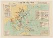
太平洋戰爭日本陸軍戰力喪失一覽圖
1 : 15000000 太平洋戰爭日本陸軍戰力喪失一覽圖 昭和二十二年[1947]4月30日,植野錄夫 编辑,东京:日本地圖株式會社发行。 此图反映了二战反攻阶段东亚、东南亚和太平洋地区盟军与日军的战斗形势,包括东北苏军进攻路线、中国本部反攻路线、东南亚和太平洋诸岛美军进攻路线等。图中用蓝色标注了此时日军在中国、东南亚及本岛的军队部署及战争损失统计。附表罗列自1937年以来日本历次战争的名称、时间、参战部队及军力损失。另有《飛行機生産表》,显示日军战机的生产配备情况。 附插图1幅:《内地戰災被害状況圖》。 1图,彩色,日文,图幅61 x 86 cm,比例尺1:15,000,000,经纬度E80°-W160°;S10°-N55°。 Harvard-Yenching | Manchuguo J-0827;Hollis Number:014623825 植野錄夫 日本地圖株式會社
Map of Hindoostan, Farther India, China, and Tibet.
from Mitchell's new general atlas, containing maps of the various countries of the world, plans of cities, etc., embraced in fifty-three quarto maps., forming a series of eighty four maps and plans, together with valuable statistical tables.

Ost-Indien
Hand-Atlas über alle Theile der Erde und über das Weltgebäude Stieler, Adolf Justus Perthes
Ost-Indien
Handatlas über alle Theile der Erde und über das Weltgebäude Stieler, Adolf Justus Perthes
Ost-Indien mit den Inseln
Hand-Atlas über alle Theile der Erde nach dem neuesten Zustande und über das Weltgebäude Stieler, Adolf bei Justus Perthes
Indiæ orientalis, nec non insularum adiacentium nova descriptio / per Nicolaum Visscher
1 : 15000000 1 Karte : Kupferdruck ; 45 x 55 cm [Nicolaes Visscher]
Russisch-Japanischer Kriegsschauplatz
1 : 12000000 Japonsko Kiepert, Richard Sprigade, Paul Dietrich Reimer

Ostindien & China
Atlas der Hydrographie Berghaus, Hermann Justus Perthes
Ost-Asien
1 : 12000000 Asie východní Kiepert, Richard Sprigade, Paul Geographische Verlagshandlung Dietrich Reimer (Ernst Vohsen)